geo.wikisort.org - Mountains
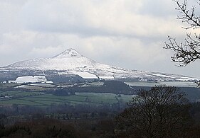
Great Sugar Loaf (Irish: Ó Cualann, meaning 'lump of Cualu')[2] at 501 metres (1,644 ft), is the 404th–highest peak in Ireland on the Arderin scale,[3] however, being below 600 m it does not rank on the Vandeleur-Lynam or Hewitt scales.[4][5] The mountain is in the far northeastern section of the Wicklow Mountains, in Ireland, and overlooks the village of Kilmacanogue. The profile of the mountain means it can be mistaken for a dormant volcano. It owes its distinctive shape, however, to the erosion-resistant metamorphosed deep-sea sedimentary deposit from which its quartzite composition was derived.[6]
| Great Sugar Loaf | |
|---|---|
| Ó Cualann | |
 Great Sugar Loaf, from the south | |
| Highest point | |
| Elevation | 501 m (1,644 ft)[1] |
| Prominence | 216 m (709 ft)[1] |
| Listing | Marilyn, Arderin |
| Coordinates | 53°9′18″N 6°9′0″W |
| Naming | |
| English translation | lump of Cualu |
| Language of name | Irish |
| Geography | |
 Great Sugar Loaf Location in Ireland | |
| Location | Wicklow, Ireland |
| Parent range | Wicklow Mountains |
| OSI/OSNI grid | O2377613088 |
| Topo map | OSi Discovery 56 |
| Geology | |
| Mountain type | Quartzite bedrock[1] |
| Climbing | |
| Easiest route | Red Lane car-park |
Naming
According to Irish academic Paul Tempan, the term "sugarloaf" is widely applied in Britain and Ireland to hills of conical form, in much the same way that the name pain de sucre is used in France.[2] Tempan also notes that there is a widespread misconception that the term refers to a kind of bread, when it refers in fact to the stalagmite-like form in which sugar was sold up until the 19th-century, prior to the advent of granulated sugar. The traditional method for making a sugarloaf was complex, involving repeated purifications, moulding and a leaching process gradually to refine the mass of sugar, by ridding it of its associated molasses and eventually all trace of colour, leaving it a glistening white. This form of sugar is still used in the German alcoholic drink, Feuerzangenbowle.[2]
Tempan notes that a 1935 article by Eoin MacNeill in the Journal of the Royal Society of Antiquaries of Ireland (JRSAI), on placenames mentioned in the Togail Bruidne Dá Derga, suggested that Irish: Ó Cualann could refer to "sheep of Cualu", but considered it unlikely.[2]
Geography
The Great Sugar Loaf overlooks villages of Kilmacanogue and Delgany, and is just north of the Glen of the Downs. The mountain sits apart from the main nearby peaks of the Wicklow Mountains, such as Maulin 570 metres (1,870 ft) and Djouce 725 metres (2,379 ft), and it is circled by roads on all sides.[7]
The two small northern and southern shoulders of the Great Sugar Loaf are often confused as being the Little Sugar Loaf, however, this mountain lies to the east on the other side of the N11 road motorway at Kilmacanogue.[7]
Though only 501 metres (1,644 ft) in elevation, the Great Sugar Loaf's isolation from other hills gives it a large proportional prominence of 216 metres (709 ft), and qualifies it as a Marilyn.[8] In addition, the steep slopes and volcanic appearance of the Great Sugar Loaf add to the distinctiveness of its profile.[7]
Geology
The Great Sugar Loaf is composed of Cambrian Period quartzite bedrock (called the Bray Head Formation), in contrast to the rounded Wicklow Mountains to the west, which are mostly made of Devonian Period granite. The Great Sugar Loaf is also popularly mistaken for a dormant volcano, however, it is instead an erosion-resistant metamorphosed sedimentary deposit from the deep sea.[6][9] Cambrian quartzite metamorphosed from sandstone at the bottom of deep oceans is extremely resistant to weathering.[6]
The Kilmacanogue valley, which the Great Sugar Loaf overlooks, was part of a regional north-south subglacial meltwater drainage route that included the Scalp (to the north) and the Glen of the Downs (to the southeast).[6]
Hill walking
The Great Sugar Loaf is popular with hill walkers given its proximity to Dublin, access from the N11 motorway, and relatively worn pathways that do not require full hiking boots or extensive navigation skills. In addition, the mountain also offers some mild scrambling up rocky gullies which adds to its appeal.[7]
The easiest route is from the south, starting from an established large car-park (O235119) situated off the middle of the Red Lane road (also known as the L1031 road) that runs along the southern boundary of the mountain; the car-park is already at an elevation of circa 290 metres (950 ft), and thus the total climbing elevation required is only 210 metres (690 ft). The 3.5-kilometre route from the car-park to the summit and back takes between 1–1.5 hours, and includes a walk over flat moorland paths and a final scrambling ascent through some rocky gullies.[7]
A longer route can be done from the east, starting from lower down at the Kilmacanogue GAA car-park (O233141); this 5-kilometre route from the car-park to the summit and back takes 2–2.5 hours, and is mostly on moorland paths with some scree and gravel sections.[7]
Bibliography
- Fairbairn, Helen (2014). Dublin & Wicklow: A Walking Guide. Collins Press. ISBN 978-1848892019.
- Fairbairn, Helen (2014). Ireland's Best Walks: A Walking Guide. Collins Press. ISBN 978-1848892118.
- MountainViews Online Database (Simon Stewart) (2013). A Guide to Ireland's Mountain Summits: The Vandeleur-Lynams & the Arderins. Collins Books. ISBN 978-1-84889-164-7.
Gallery
 From the west in Winter.
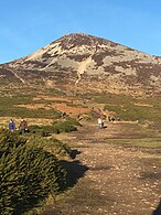 From the Red Lane car-park.
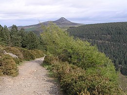 From Maulin.
 View to Little Sugar Loaf.
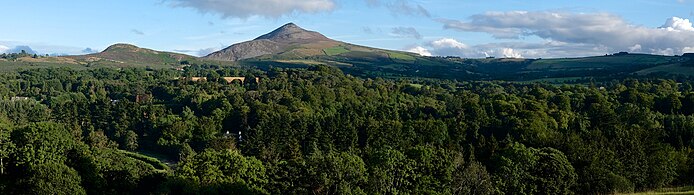 From the Powerscourt Estate


See also
- Wicklow Way
- Wicklow Mountains
- Lists of mountains in Ireland
- List of mountains of the British Isles by height
- List of Marilyns in the British Isles
References
- "Great Sugar Loaf". MountainViews Online Database. Retrieved 11 July 2019.
- Paul Tempan (February 2012). "Irish Hill and Mountain Names" (PDF). MountainViews.ie.
- Simon Stewart (October 2018). "Arderins: Irish mountains of 500+m with a prominence of 30m". MountainViews Online Database.
- Simon Stewart (October 2018). "Vandeleur-Lynams: Irish mountains of 600+m with a prominence of 15m". MountainViews Online Database.
- Mountainviews, (September 2013), "A Guide to Ireland's Mountain Summits: The Vandeleur-Lynams & the Arderins", Collins Books, Cork, ISBN 978-1-84889-164-7
- Sile Daly (May 2016). "The Great Sugar Loaf: Geological Context" (PDF). Irish Mountaineering Club. Retrieved 11 July 2019.
Popularly mistaken for a volcano, its metamorphism has rendered the rock extremely erosion-resistant and the mountain owes its shape to the weathering characteristics of quartzite.
- Fairbairn, Helen (2014). Ireland's Best Walks: A Walking Guide. Collins Press. ISBN 978-1848892118.
Route 57: Great Sugar Loaf
- Chris Cocker; Graham Jackson (2018). "The Database of British and Irish Hills". Database of British and Irish Hills.
- Michael Viney (1 November 1997). "Moving Mountains". Irish Times. Retrieved 11 July 2019.
The peak of the Great Sugar Loaf was never a volcano, but started life as sand on the ocean floor.
External links
- MountainViews: The Irish Mountain Website, Great Sugar Loaf
- MountainViews: Irish Online Mountain Database
- The Database of British and Irish Hills , the largest database of British Isles mountains ("DoBIH")
- Hill Bagging UK & Ireland, the searchable interface for the DoBIH
| British Isles |  | |
|---|---|---|
| Scotland | ||
| Outside Scotland | ||
| England | ||
| Ireland | ||
| County tops |
| |

Lists of long-distance trails in Ireland | ||||||
|---|---|---|---|---|---|---|
| Long-Distance |
|   | ||||
| Pilgrim path |
| |||||
| Cycle greenway |
| |||||
| Boarded mountain | ||||||
| Fell running | ||||||
На других языках
[de] Great Sugar Loaf
Der Great Sugar Loaf (irisch Ó Cualann) ist ein Berg im Osten des County Wicklow in Irland.- [en] Great Sugar Loaf
[fr] Great Sugar Loaf
Le Great Sugar Loaf (en irlandais : Ó Cualann ou Beannach Mhór) est un sommet des montagnes de Wicklow culminant à 501 mètres d'altitude, en Irlande, au sud-ouest de Bray et au nord de la réserve naturelle du Glen of the Downs. Le Little Sugar Loaf se trouve à l'est-nord-est, sur l'autre côté de la route N11 reliant Wicklow à Dublin. En raison de son isolement et de ses versants pentus résultant de l'érosion des roches alentour, le sommet paraît plus élevé qu'il ne l'est ; il est classé en tant que marilyn. Composé de quartzite formée au Cambrien[1], il contraste avec les sommets de granite du Dévonien à l'ouest.Другой контент может иметь иную лицензию. Перед использованием материалов сайта WikiSort.org внимательно изучите правила лицензирования конкретных элементов наполнения сайта.
WikiSort.org - проект по пересортировке и дополнению контента Википедии