geo.wikisort.org - Mountains
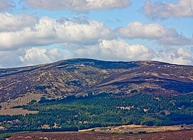
Carrigvore (Irish: Carraig Mhór, meaning 'big rock')[2] at 682 metres (2,238 ft), is the 111th–highest peak in Ireland on the Arderin scale,[3] and the 134th–highest peak on the Vandeleur-Lynam scale.[4][5] Carrigvore is in the middle section of the Wicklow Mountains, in Ireland, and is part of a large north-east to south-west "boggy ridge" that runs from the Sally Gap to Carrigvore, and then on to Gravale 718 metres (2,356 ft); after a col, the ridge continues south-westwards to meet Duff Hill 720 metres (2,360 ft), which is part of the larger massif of Mullaghcleevaun 849 metres (2,785 ft).[6][7]

| Carrigvore | |
|---|---|
| Carraig Mhór | |
 Gravale (highest) with Carrigvore (right) from SE | |
| Highest point | |
| Elevation | 682 m (2,238 ft)[1] |
| Prominence | 67 m (220 ft)[1] |
| Listing | Hewitt, Arderin, Simm, Vandeleur-Lynam |
| Coordinates | 53.130277°N 6.323459°W |
| Naming | |
| English translation | big rock |
| Language of name | Irish |
| Geography | |
 Carrigvore Location in Ireland | |
| Location | Wicklow, Republic of Ireland |
| Parent range | Wicklow Mountains |
| OSI/OSNI grid | O122101[1] |
| Topo map | OSi Discovery 56 |
| Geology | |
| Mountain type | Granite with microcline phenocrysts[1] |
| Climbing | |
| Easiest route | from the Sally Gap, or along the R115 |
See also
- Wicklow Way
- Wicklow Mountains
- Lists of mountains in Ireland
- List of mountains of the British Isles by height
- List of Hewitt mountains in England, Wales and Ireland
References
Citations
- "Carrigvore". MountainViews Online Database. Retrieved 15 July 2019.
- Paul Tempan (February 2012). "Irish Hill and Mountain Names" (PDF). MountainViews.ie.
- Simon Stewart (October 2018). "Arderins: Irish mountains of 500+m with a prominence of 30m". MountainViews Online Database.
- Simon Stewart (October 2018). "Vandeleur-Lynams: Irish mountains of 600+m with a prominence of 15m". MountainViews Online Database.
- Mountainviews, (September 2013), "A Guide to Ireland's Mountain Summits: The Vandeleur-Lynams & the Arderins", Collins Books, Cork, ISBN 978-1-84889-164-7
- Fairbairn, Helen (2014). Dublin & Wicklow: A Walking Guide. Collins Press. ISBN 978-1848892019.
- Dillion, Paddy (1993). The Mountains of Ireland: A Guide to Walking the Summits. Cicerone. ISBN 978-1852841102.
Walk 4: Carrigvore, Gravale, Duff Hill, Mullaghcleevaun East Top, Mullaghcleevaun
Bibliography
- Fairbairn, Helen (2014). Ireland's Best Walks: A Walking Guide. Collins Press. ISBN 978-1848892118.
- Fairbairn, Helen (2014). Dublin & Wicklow: A Walking Guide. Collins Press. ISBN 978-1848892019.
- MountainViews Online Database (Simon Stewart) (2013). A Guide to Ireland's Mountain Summits: The Vandeleur-Lynams & the Arderins. Collins Books. ISBN 978-1-84889-164-7.
- Dillion, Paddy (1993). The Mountains of Ireland: A Guide to Walking the Summits. Cicerone. ISBN 978-1852841102.
External links
- MountainViews: The Irish Mountain Website, Carrigvore
- MountainViews: Irish Online Mountain Database
- The Database of British and Irish Hills , the largest database of British Isles mountains ("DoBIH")
- Hill Bagging UK & Ireland, the searchable interface for the DoBIH
Текст в блоке "Читать" взят с сайта "Википедия" и доступен по лицензии Creative Commons Attribution-ShareAlike; в отдельных случаях могут действовать дополнительные условия.
Другой контент может иметь иную лицензию. Перед использованием материалов сайта WikiSort.org внимательно изучите правила лицензирования конкретных элементов наполнения сайта.
Другой контент может иметь иную лицензию. Перед использованием материалов сайта WikiSort.org внимательно изучите правила лицензирования конкретных элементов наполнения сайта.
2019-2025
WikiSort.org - проект по пересортировке и дополнению контента Википедии
WikiSort.org - проект по пересортировке и дополнению контента Википедии


