geo.wikisort.org - Mountains
The Ben of Howth (/ˈhoʊθ/ HOHTH; Irish: Beann Éadair ) is a hilly area[2] on Howth Head, adjacent to the 171 metre high Black Linn,[2] the peninsula's highest point.[2]
| Ben of Howth | |
|---|---|
| Beann Éadair | |
 Ben of Howth Radio Mast | |
| Highest point | |
| Elevation | 171 m (561 ft)[1] |
| Prominence | 167 m (548 ft)[1] |
| Listing | Marilyn |
| Geography | |
 Ben of Howth Location in Ireland | |
| Location | Dublin, Ireland |
| OSI/OSNI grid | O285376 |
| Topo map | OSi Discovery 50 |
Geography
Lying approximately 1½ km to the south of Howth village, the nearest road is Windgate Road, from which a path leads west past Green Hollows quarry.
Two of Howth's other peaks are nearby, Shelmartin or Shielmartin[2] which lies approximately 1 km to the west, and Dun Hill,[2] 0.5 km to the north west.
Gallery
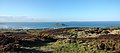 North-facing view
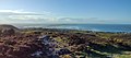 Northwest facing view
 Ben of Howth, southwest facing view
 Ben of Howth, east view


References and notes
- "East Coast Area - Ben of Howth". MountainViews. Ordnance Survey Ireland. Retrieved 5 July 2015.
- The Neighbourhood of Dublin - Chapter 32, Weston St John Joyce, Dublin, MH Gill and Son, 1912, - multiple mentions

Текст в блоке "Читать" взят с сайта "Википедия" и доступен по лицензии Creative Commons Attribution-ShareAlike; в отдельных случаях могут действовать дополнительные условия.
Другой контент может иметь иную лицензию. Перед использованием материалов сайта WikiSort.org внимательно изучите правила лицензирования конкретных элементов наполнения сайта.
Другой контент может иметь иную лицензию. Перед использованием материалов сайта WikiSort.org внимательно изучите правила лицензирования конкретных элементов наполнения сайта.
2019-2026
WikiSort.org - проект по пересортировке и дополнению контента Википедии
WikiSort.org - проект по пересортировке и дополнению контента Википедии