geo.wikisort.org - Island
Brač is an island in the Adriatic Sea within Croatia, with an area of 396 square kilometres (153 sq mi),[1] making it the largest island in Dalmatia, and the third largest in the Adriatic. It is separated from the mainland by the Brač Channel, which is 5 to 13 km (3 to 8 mi) wide.[2] The island's tallest peak, Vidova gora, or Mount St. Vid, stands at 780 m,[3] making it the highest island point of the Adriatic islands.[4] The island has a population of 13,931,[5] living in twenty-two settlements, ranging from the main town Supetar, with more than 3,400 inhabitants, to Murvica, where less than two dozen people live. Brač Airport on Brač is the largest airport of all islands surrounding Split.
 | |
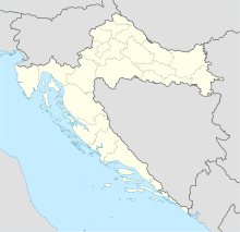 Brač Location of Brač | |
| Geography | |
|---|---|
| Location | Adriatic Sea |
| Coordinates | 43°19′N 16°38′E |
| Archipelago | Dalmatian Archipielago |
| Area | 396 km2 (153 sq mi) |
| Highest elevation | 780 m (2560 ft) |
| Highest point | Vidova gora |
| Administration | |
Croatia | |
| County | Split-Dalmatia |
| Largest settlement | Supetar (pop. 3,326) |
| Demographics | |
| Population | 13,931 (2021) |
| Pop. density | 35/km2 (91/sq mi) |
| Ethnic groups | Croats |
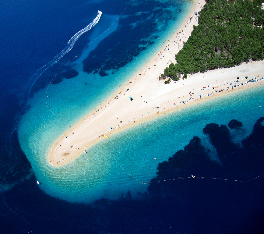
Brač is known as a tourist destination, for the Zlatni Rat beach in Bol, the marina in Milna, the white limestone which was used for the palace of Diocletian, the stone mason school in Pučišća, the oldest preserved text written in the Croatian language, the author Vladimir Nazor, its olive oil with protected designation of origin, the Kopačina cave near Donji Humac with archaeological findings dating to the 12th millennium BCE, the Blaca hermitage, and other things.
Name
Brač (pronounced [brâːtʃ]) is known in the local Chakavian Broč (pronounced [broːtʃ]). In Latin Latin: Bretia or Brattia, in Italian Italian: Brazza. The Greek name of the island was Elaphousa, apparently derived from elaphos "stag". Based on this, it has been speculated that the original name of the island may have been derived from Messapic *brentos ("stag"). The Messapic word is deduced from a gloss "brendon — elaphon [deer]". [6] Polybius and Plinius record the name of the island as Brattia.[7] Other names through history for Brač have been Brectia, Bractia, Brazia, Elaphusa, Bretanide and Krateiai (in the Periplus of Pseudo-Scylax, identification unsure).[8]
Geography

Brač is with an area of 396 square kilometres (153 sq mi) the largest island in Dalmatia, and the third largest island in the Adriatic Sea overall. The island is roughly oval shaped, being almost 40km wide from east to west, and about 14km north to south. Brač has a long and folded coastline with a length of more than 180km, with numerous smaller and larges bays. Particularly noticeable are the natural harbours of Supetar, Splitska, Pučišća, and Povlja, Sumartin, Milna and Bobovišća.
Brač is separated from the mainland to the north by the Brač Channel, which is 5 to 13 km (3 to 8 mi) wide and down to 78m deep.[9] To the north it faces Split and Omiš. To the east it is separated from the mainland by a continuation of the Brač channel, with distances between 6km at Baška voda up to 10km at Makarska. To the south it faces the neighbouring island of Hvar, separated by the Hvar Channel with a maximal depth of 91m. The closest distance is between Murvica and the northern beachs of Hvar with less than 4km, up to about 14km at the east and west ends of Brač. To the west, it is separated from the island of Šolta by the Split Gates, which is about 800m wide. The uninhabited islet of Mrduja lies in the Split Gates. In an annual event, people from Brač and people from Šolta play a game of tug of war over the islet.
The island has been called the island without water (otok bez vode), but it does have a small number sweet water springs. Most of the water needs to be brought from the mainland from the Cetina river through a pipe. An artificial tunnel has been built from the northern side of the island through the mountain to the south side, in order to allow the pipe to continue and serve not only Bol and Murvica, the two sole settlements on the southern side of the island, but also to continue to the neighbouring island Hvar.
The island is more rugged and mountainous than any of the other Dalmatian islands. The island's tallest peak, Vidova gora, or Mount St. Vid, stands at 780 m,[3] making it the highest island point of the Adriatic islands.[10] The south side of the island is particularly steep, as the distance from the beach to the Vidova Gora peak in only about 2km - and 780 meters up. The steepness of the south side makes the many natural bays hard to reach. Because of that, the south side of the island only has two settlements, Bol and tiny Murvica. It also makes the south side particularly amenable for vineyards. The inner north west and the inner south east of the island are high plateaus. Until the middle ages, most of the population lived on these inland plateaus.

Geology
The island is mostly made of limestone, which has shaped the history and economy of the island. The limestone originated in the Cretaceous about 100 million years ago, but Brač became an island only after the last ice age, (within the last 12,000 years, in the Holocene). Due to erosion and sedimentation, the island also has sandstone, breccia, clay, and terra rossa.
Administration

The island is administratively divided into eight units, one city (a type of municipal unit with a larger town) and seven municipalities. These cover the twenty-two currently populated settlements of the island. Population numbers are given per 2021 census. The island is part of the Split-Dalmatia County, but is not represented there as a whole, only through its city and municipalities.
The division into seven municipalities and a city happened after the administrative reorganisation of Croatia following Croatian independence in 1991. Before that, Brač was a single municipality (općina) in Yugoslavia with Supetar as the seat of the municipality. Still today, many of the administrative duties for the other seven municipalities are delegated to the city of Supetar.
With the arrival of the Narentines in the seventh or eighth century, the now abandoned Gradac became the first administrative centre of Brač. Venice declared in the late tenth century that Nerežišća should become the administrative and governmental centre of Brač. In 1827 this role was given to Supetar by the Austro-Hungarian administration. The island was divided into 21 cadastral communities by the Austro-Hungarian administration - corresponding to the currently existing settlements besides Ložišća, which was a part of Bobovišća. These cadastral communities were mostly preexisting administrative units and not introduced by the Austro-Hungarians.
In terms of the Roman Catholic church, the island is has 23 parishes: one for each of the settlements, and an additional one for the hermitage Blaca. All parishes of Brač have been part of the Roman Catholic Diocese of Hvar-Brač-Vis, with the seat of the Bishop in Hvar since it was founded in 1145, and belonged previously to the Diocese of Salona.
Settlements
The twenty-two populated settlements of Brač are subdivided into eight municipal units (see Administration for more details). A number of small unincorporated settlements can be found in the Selca municipality, including Nadsela, Podsmrčevik, Osridke, Nakal, and Nagorinac. The island also has a number of abandoned settlements, such as Podhume, Smrka, Straževnik, Gradac, Dubravica i Mošuje, Podgračišće, and others. Other places of interest are the Blaca hermitage and Drakonjina špilja.
History
The Kopačina cave near Donji Humac is one of the oldest traces of human habitation in Dalmatia. And yet, Brač has been called island without history (otok bez povijest) by Vladimir Nazor, easily the island's most well known author. Unlike all of the other larger islands, neither the Illyrians (who arrived in the 2nd millennium BCE), nor the Greek (4th century BCE), nor the Romans (1st century CE) have established a larger settlement on the island. It is only well after the Slavs settled (8th century) and the Venetians took over the administration of the island (10th century), that the island saw larger settlements and towns develop. First, Gradac was the administrative centre, which moved to Nerežišća between 937 and 1000, and finally Supetar in 1827.
The history of Brač follows mostly the history of Dalmatia. Who ruled the island changed frequently. Some, like Rome or Venice, ruled for centuries, others, like the Normans, for a single year. But independently of who ruled the island, the island had an internal autonomous administration as described in the statutes of Brač, which allowed the island to develop a certain continuity - independently of whether the island was ruled from Byzantium, Vienna, or Paris. More important were the constant attacks by pirates, particularly from the Narentines and later the Kačić family in Omiš, which kept Brač in poverty and didn't allow for towns to develop along the coast well into the 15th century.
Prehistory (before the 3rd century BCE)

Archaeological findings in the Kopačina cave between Supetar and Donji Humac have been dated to the 12th millennium BCE. These are some of the oldest traces of human habitation in Dalmatia.[11] The findings show that the cave has been inhabited until the 3rd millennium BCE (although not continuously). Some of the artefacts have originated in the Dalmatian hinterland, showing that Brač was part of a trade network with the mainland. In the Stone Age, the population seemed to have lived mostly inland.
In the second millennium BCE, the Illyrians moved in from the North and Northeast to the Balkan peninsula, including Brač. They replaced the previous population.[12]
In the Bronze Age and Iron Age, it is assumed that numerous villages existed. Most of them seemed to have been in the eastern high plane of the island, and thus it is assumed that they lived on animal husbandry. Numerous simple fortifications, mostly built using dry stone constructions, indicate that the population was expecting to defend itself against attacks.[13]
In the 4th century BCE Greek colonisation spread over many Adriatic islands and along the coast, but none of them have been found on Brač. In Škrip, traditionally known as the oldest existing settlement on the island, old walls have been found built in the Greek style, but it would be the only Greek colony which has been built inland instead along the coast, which is why it is unlikely to be a Greek colony. It remains an open question whether Brač had any organised Greek colonies, and if it did not, why.[14] Nevertheless, Greeks visited the island and also traded with the Illyrian inhabitants. The toponomy of two of the southern bays still preserve the memory of such a trade: Farska (Hvarska in modern Croatian, referring to the old colony of Pharos on Hvar) and Garška (Grčka in modern Croatian, meaning Greek).
Brač lay on the crossroads of several trade routes from Salona (today Solin) to Issa (today Vis) and the Po River. Greek artifacts were found in the bay of Vičja near Ložišća on the estate of the Rakela-Bugre brothers. Many of the objects belonging to this still unexamined site are now on display in the Split Archaeological Museum.
Roman era (3rd century BCE-8th century CE)

Increased attacks from Illyrians on Greek colonies such as Pharos on neighbouring island Hvar and Roman trade routes lead to a time of upheaval and change that started with the Illyro-Roman Wars in 229 BCE and the establishment of a Roman protectorate covering the surrounding Greek colonies. Over the years, the area increasingly fell under Roman rule, with the establishment of the provinces of Illyricum and Dalmatia 32-27 BCE, including Brač. More peaceful times finally began after 9 CE, following the end of the Great Illyrian uprising.
Salona became the capital of the new Dalmatia province and, probably because of its proximity to Salona, Romans increased their usage of the island. Signs of Roman habitation are widespread, but they usually are limited to single Roman villas, cisterns, and either near early quarries between Škrip and Splitska or near vineyards and olive orchards. Splitska became the most important harbour to carry stone to Salona and the whole of Dalmatia. It is likely that slaves had to work in the quarries, originally prisoners of wars, but later often from the local population. From 295 to 305 CE, Diocletian's Palace in Split was largely built with limestone that was quarried on Brač.[15] Also agriculture, especially wine and olives, began in the same era. But no larger town or municipality on Brač that was inhabited in the Roman era is known today.
Roman walls, villas, sarcophagi, cisterns, and tools for making wine, olive oil, and keeping sheep and goats have been found in or neat a number of today's coastal towns, such as Bol, Pučišća, Povlja, Supetar, Novo Selo, and the Lovrečina bay.[16] In the inland, particularly around Nerežišća, Škrip, Donji Humac, and Dračevica, wine, olives, and figs, as well as sheep and goats were grown. Near Škrip, inscriptions praising the god Liber have been found, near Donji Humac sarcophagi, and near Dračevica coins. Pliny the Elder mentions Brač as for its famous goats in his Naturalis Historia. Numerous water reservoirs (lokva) date to that time, and are still in use.[17]
Some of the artefacts from the early time of Roman rule are devoted to numerous gods from a diverse set of pantheons, most frequently Heracles. Other divine beings for whom devotional objects have been found include Mithra, Jupiter, Jupiter Dolichenus as a form of worship for Baal, Mercury, Neptune, Silvanus, Pan, the Muses, and Liber.[18] Christianity seemed to have arrived on the island only after Constantine's declaration of the Edict of Milan: old Christian churches from the fifth and early sixth century are known in Sutivan, the bay of Lovrečina, Saint Andrew (Sveti Jadre) above Splitska, and Saint Theodore (Sveti Tudor) near Nerežišća.[19] No pagan artefacts date newer than the arrival of Christianity on the island.

When the Roman empire split in 395 CE, Brač became a part of the Western Roman empire as part of Dalmatia. Roman rule over Brač and Dalmatia survived the Fall of the Western Roman Empire in 476 CE to the Gothic invasion, as emperor Nepos fled to Dalmatia. The Goths conquered Dalmatia after Nepos' assassination in 480 CE.
Gothic rule extended until 555, when Eastern Roman rule over Dalmatia and Brač was restored by Justinian.[20]
The Pannonian Avars sacked and destroyed Salona in 614[21] (or 639, according to other sources) and Brač became a refuge. The Dalmatian region and its shores were at this time settled by tribes of Croats, a South Slavic people subservient to the Avar khagans,[22] but the Salonans fled to Split, Brač and other islands. Tradition has it that Škrip was founded by refugee Salonans, but the town is actually older than that.
Split and other Dalmatian city-states, together with Brač and other islands, became the remnants of the Roman province of Dalmatia. First, they recognised the rule of the Exarchate of Ravenna, but after the end of the Exarchate due to the Lombards, it became the predecessor to the Theme of Dalmatia, an independent unit recognising the supremacy of the Byzantine empire. Byzantine gold coins have been found near Nerežišća indicating Byzantine rule. This lasted through most of the seventh and eight century.[23]
Arrival of the Slavs (9th and 10th century)

On the mainland, the South Slavic tribe of the Narentines had founded its own state in the seventh century. Sometime during the eighth or ninth century, the Narentines landed either in harbours near Selca on the east of Brač, or first went through Hvar and then landed on the Hrvaska bay (Hrvatska, Croatian bay) in the south-west of Brač. This is still noticeable in a lot of toponyms and even in the different dialects on the island, where the western part of the island retains many of the Roman elements, but the eastern part is more Slavic. By the ninth century, the Narentines had a solid rule over Brač. Brač and Hvar and surrounding islands were called the Narentine islands or Maronia.[24] The Narentines, also known as Paganians, were not Christian, bringing a pagan population back to Brač.[25] The Nerantines used Brač mostly for animal husbandry.
The likely administrative and political centre of Brač for the Narentines was Gradac, which is located between Gornji Humac and Selca on the Eastern plateau of Brač, and which was likely founded by Narentines shortly after their arrival. Today, only ruins are left of Gradac.
At the turn of the eighth to the ninth century, Charlemagne attacked and conquered much of Dalmatia, but not Brač or the other Narentine islands. Charlemagne returned Dalmatia to the Byzantine empire in 812 during the negotiations for the Pax Nicephori.
The Narentines were frequently attacking Venetian ships. In 837, the Venetian Doge Pietro Tradonico came first to Split, and then to Brač and Hvar to find a way to stop the attacks, first with force, and then with diplomacy. In 839, Venice signed a treaty with the Narentine knez (duke) Družko (Drosaico), which was broken within a year.[26]
In 872, Saracene (Arab) raiders from Crete attacked Brač.[27] It is unclear what exactly they attacked, as the sources speaks of a "urbs Braciensem". Given that there still was no proper city, it may refer to the Vidova Gora as the highest point of the island, and thus to the area around today's Bol, or it might be a literal translation of Gradac.[28]
Following the Christianisation of the Narentines in 878-880, Christianity on Brač got a new boost. Particularly the Benedictines started to become a dominant influence for the islands sacral life. Andrija Ciccarelli mentions seven monasteries on the island: St Mary (Sv Marija) in Postira, Mirje na Brigu near Postira, St Lawrence (Sv Lovro) in the Lovrečina bay, St Stephen (Sv Stipan) in Stipanska luka (Stephen's harbour) in today's Pučišća, St Andrew (Sv Jadre) near Nerežišća, and one in Povlja (likely St John the baptist, Sv Ivan Krstitelj) and near Murvica (possibly the Dragon's cave, Drakonjina špilja).[29] A number of old Croatian churches were built during the ninth to the twelfth century: St Nicholas (Sv Nikola) above Selca, St Michael (Sv Mihovil) above Dol, St Elias (Sv Ilija) near Donji Humac, St George (Sv Juraj) near Nerežišća, St Clement (Sv Kliment) near Pražnica, St John and Theodore (Sv Ivan i Teodor) in Bol, St George (Sv Juraj) in Straževnik, St Cosmas and Damian (Sv Kuzma i Damjan) above Smrčevik, Holy Sunday (Sv Nedija) above Gradac, All Saints (Svi Sveti) near Gornji Humac belonging to the village of Mošuja and Dubravica.[30]
Dujam Hranković lists a number of old Croatian towns on the eastern plateau of Brač, which do not exist today anymore: Gradac, Mošuje and Dubravica, Straževnik, Pothume, and Podgračišće. The houses of that time usually had one single, rectangular room, were built with dry wall construction, with the door facing south. They often feature the tools necessary for animal husbandry, have a cistern, a fireplace, an oven, olive mills, wine presses, and wheat grinder.[31]
Around 923, Tomislav of Croatia, Byzantine Emperor Constantine VII and the two church patriarchs were involved a deal that transferred the control of the Byzantine Dalmatian cities to the new Croatian kingdom, which according to Vrsalović included Brač.[32] But following Tomislav's death, Croatia weakened, and in the 940s, the islands of Brač and Hvar seceded during Ban Pribina's rebellion and rejoined the Narentine state.
The end of Byzantine claim (1000-1186)
In 1000 CE, the Venetian doge Pietro II Orseolo decided to finally pacify Dalmatia and the Narentines. Venice conquered Brač in the same year, and according to the Brač chronicler Andrea Ciccarelli, they immediately built a palace in Nerežišća to serve as a court, for administration, as an archive, and for council meetings. This moved the centre of power from the Slavic Gradac in the east of the island to the Roman Nerežišća. Nerežišća remained the administrative centre of the island for more than eight centuries, until 1823 when the Austro-Hungarian empire moved it to Supetar.
Doge Pietro II Orseolo also received Stephen as a hostage, the son of the Croatian king Svetoslav Suronja. Stephen later married the daughter of the Doge, Joscella Orseolo. Their son Peter followed Stephen to become King of Croatia in 1058, as Peter Krešimir IV the Great. Early in his reign, Peter expanded Croatia to its largest extend, also including Brač and the other islands.
An attack by Normans from the south of Italy in 1075 lead to the capture of a number of Dalmatian cities and islands, including Brač. The Normans were invited by the Dalmatian cities in order to protect them from Croatian influence. Venice attacked and conquered the Norman possessions in 1076.[33]
In 1102, Coloman, King of Hungary unified the crown of Hungary with the crown of Croatia. The Life of St Christopher the Martyr says that a Hungarian fleet subjugated several Dalmatian islands, including Brač.[34][35] In 1107, emperor Alexios I gave the Dalmatian theme, including Brač, to Coloman to administer in the name of the Byzantine empire. The fleet of Venice, commanded by Doge Ordelafo Faliero, invaded Dalmatia in August 1115 and retook the islands.[36][37] In an attack in either 1117 or 1118, during which Doge Ordelafo Faliero himself died, the Hungarians retook Dalmatia.[37] The new doge, Domenico Michele, invaded and reconquered Dalmatia.[38] In 1124, Stephen II of Hungary invaded Dalmatia, but were reconquered by Venetia soon after.[39] Either Stephen II's son Béla II in 1136,[40][41] but latest his son Géza II in 1142,[42][43][44] again regained sovereignty over Split and other parts of Dalmatia for Hungary.
In the 1140s, Split was under Hungarian control, and Brač and Hvar were under Venetian control, probably recently conquered. Venice asked the Catholic church to establish Brač and Hvar as its own diocese and take it off from Split and thus Hungarian control. Venice further arranged for the diocese of Zadar (which was under Venetian control) to be raised to an archdiocese, and for the newly formed diocese of the islands to be subject to Zadar. In 1147, Brač and Hvar elected Marin Manzavin from Zadar to become the first Bishop of Hvar, and they chased archpriest Cernat from Split off the island.[45] Soon after a palace in Bol was available for the Bishop, where he could reside when he was on Brač. The leader of the church of Brač was the archpriest in Nerežišća, elected by the priests of the island's parishes and confirmed by the bishop in Hvar.
In 1145, pirates from Omiš under the Kačić family attacked Brač for the first time. This seems to be a continuation of the pirate attacks of the Narentines, who were located in the same area. The attack robbed the Benedictine abbey in Povlja, and killed the monks. In the following decades, the attacks by Omiš pirates would increase in frequency, suppressing any development of towns along the coast of Brač.[46]
In 1164, Byzantine emperor Manuel I Komnenos started a war against King Stephen III of Hungary and succeeds in gaining control over Dalmatia, letting Venice administer the area. Counterattacks by Stephen are withouts success. Only after the death of emperor Manuel I in 1180, Stephen's brother and successor as King of Hungary, Béla III, was able to take control of Dalmatia again, seemingly without bloodshed and with support of Byzantine authorities, who seemed to now prefer Hungarian over Venetian rule.[47] A peace treaty was signed in 1186 between Béla III and emperor Isaac II Angelos,[48] which lead to the empire formally giving up its claim over Dalmatia.[49]
A document from 1184 survived as a copy, the Charter of Povlja written in 1250. This is one of the oldest Croatian linguistic records. It discusses some landownership of the Benedictine monaster of St John in Povlja. It mentions the roles of the knez (lord or prince) of Brač (a certain Brečko), the župan (administrative head, elder), a judge, and bailiffs. Vrsalović thinks it likely that this administrative structure is rooted already in Narentine times and had endured and evolved throughout the many changes and conquests of the island.[50] The island was never rich or strategically interesting enough to justify serious intervention. When the ruler of the island changed, the new rulers often simply confirmed the statutes of Brač and the freedoms and rights of the islanders. Sometimes they even negotiated for more rights.[51] The fact that the document was written in Croatian, and not in Latin or Hungarian, is also a testament to the autonomy of the island, which was developed independently and peacefully despite the wars waged by Hungary, Venice, and Byzantium.
Hungarian rule 1180s-1278
With Béla III controlling Zadar, Split, Hvar and Brač, the Archbishop of Split intervened with the Pope for the Diocese of Hvar and Brač to be moved from Zadar to Split. The Papal legate Thebaldus ruled in 1181 in favour of Split, but Zadar didn't want to give up so lightly. After the death of the first bishop Martin Manzavin, the islands elected his nephew Nicolas as the new bishop, but the Metropolitan of Split didn't confirm Nicloas. Nicolas went to Verona to Pope Lucius III, who confirmed him directly. Pope Celestine III decided with a papal bull in 1192 that the diocese of Hvar should be subject to the Archdiocese of Split. Nicolas remained Bishop of Hvar until 1198, when he assumed the vacant Archbishopry in Zadar, against the will of Pope Innocence III, for which Nicolas was suspended.[52]
In 1217, Béla's son and, King Andrew II of Hungary, landed the southern side of Brač near today's Bol on his way to the Fifth Crusade. He was greeted by the Lord of Brač (knez), representatives of the Brač council, and the Bishop of Hvar.[53]
In the meantime, the pirate attacks from the Omiš' Kačić family became worse. In 1220, Brač pleaded for help from King Andrew II. The king answered with an order to knez Malduč Kačić to cease the attacks, threatening his whole family. In 1221, Pope Honorius III sent legate Aconcius to prevent piracy, and in 1222, the pope sought help from residents of Dubrovnik against the Omiš pirates.[54]
In 1221, King Andrew II gifts the islands of Brač, Hvar, Korčula, and Lastovo to Henry and Servidon Frankopan in recognition for their services. It is unclear in what way and for how long they enjoyed their gift, but before 1240 Brač had elected Osor Kačić as their new knez (Lord), and on neighbouring Hvar had his brother Pribislav as knez. Brač and Hvar hoped that by having the sons of knez Malduč Kačić rule over the island, the pirate attacks would cease. But Osor didn't accept the statutes of Brač, but he demanded full control of the island. The people of Brač started conspiring with Garganus, the potestas of Split, and promised him that a person from Split would become the new knez if Split helped Brač against Osor Kačić. In 1240, Split starts a war against Omiš, and although the attack on Omiš is without success, they manage to capture Brač.[55] On May 19 1240, Brač formally recognises the Split rule.[56]
This did not last long. The son and successor of Andrew II, King Béla IV, had to flee from his capital when Mongols attacked Hungary. Kadan, a son of Great Khan Ögödei, chased Béla from town to town in Dalmatia.[57][58] Béla took refugee in Split, but was unhappy with his welcome in the city,[59] and then left for the well-fortified Trogir.[57] Before Kadan laid siege to Trogir in March, news arrived of the Great Khan's death.[60][61] Batu Khan wanted to attend at the election of Ögödei's successor with sufficient troops and ordered the withdrawal of all Mongol forces.[62][63] Béla, who was grateful to Trogir, granted it lands near Split, causing a lasting conflict between the two Dalmatian towns,[64] and also took Brač away from Split and granted it to Hvar on May 10, 1242.[65]
The quarrel between Split and Trogir escalated to an armed conflict in 1244, and Brač, indebted to Split for the help against Osor Kačić, joined Split. Eventually, Trogir won that conflict, and on March 3, 1253 they signed a peace treaty and had to pay 100 lira to Trogir.[66]
One night in July 1277, Omiš pirates landed in the bay of St George (Sv Juraj) on the northern side of the island, and proceeded all the way to Nerežišća. There they laid fire to the buildings of the Brač administration. This also destroyed the archives of the island, so that most of the early documentation about the history of Brač was lost.[67]
Venetian rule 1278-1358

Following this attack, and the obvious inability of the Hungarian king to stop the incessant pirate attacks, the people of Brač and Hvar sent Šimun (Simon), Bishop of Hvar and Brač, to Venice to negotiate that the two islands would come under the supremacy of Venice, in return for protection. On April 1, 1278, the Great council of Venice votes to accept the plea.[68] Venetian administration took over on July 21, 1278, with the knez being appointed by Venice, originally for four years, but that was shortened to two years after the term of the first Venetian expired in 1282.[69]
Venice took the task of protecting Brač more serious. In 1280 they attacked and conquered Omiš itself, in order to stop the attacks, but the pirates managed to flee from the Venetians, and continued their attacks on Brač, Hvar, and now Omiš itself as well.[70] In 1282, one armed ship with eighty oars was assigned to Brač and Hvar. But the attacks continued, and Venice ordered on September 22, 1292 that Nerežišća, as the administrative capital, should be fortified with a wall, but that never happened. In 1294, another devastating attack on the monastery in Povlja happened.[71]
Due to the 1277 attack on and fire in Nerežišća, Brač was left without a written form of its statutes (laws). On bequest of the Brač nobility, knez Marino Falerio (who later became Doge of Venice) ordered in 1305 for the statutes of Brač to be rewritten. Copies of the statutes are preserved.[72]
As the Venetian rule didn't lead to the peace that Brač hoped for, Brač stopped recognising knez Giovanni Soranzo (who later became Doge of Venice) in 1309, and thus Venetian supremacy. Venice orderes the knez of Zadar and the knez of Dubrovnik to come to the help to the knez of Brač, which leads to a proper uprising in 1310 under the lead of the family Slavogost and with help from Omiš. Juraj Slavogost is elected as captain by the nobility of Brač, whereas Venice sends Andrea Goro as the new knez. Goro and his troops manage to capture Slavogost, and send him to Venice, thus retaining the islands under Venetian control.[73]
In 1317, Venice gives to more ships to Brač and Hvar, one with thirty oars, the other with seventy to eighty oars. In 1334, another ship with eighty oars is given, another in 1346. The pirate attacks could not be stopped, and in the second half of the fourteenth century the monastery in Povlja was abandoned.
Brač lived on agriculture and animal husbandry, forestry, stone quarrying, and trade with the nearby islands and coastal towns.[74] Wheat and lentils were scarce, and there was not enough of it to feed the population of the island. Therefore their export was prohibited. Agricultural produce included wheat, oat, olives, figs, pears, apples, walnuts, mulberries, and other fruits.[75] Animal husbandry focused mostly on sheep and goats, but also a few cows and bulls, mules, and donkeys.[76] In order to help with having enough water, artificial pools (called lokva in Croatian, lacus clausus in Latin) were created, mostly in the eastern plateau. Around the end of the 14th and early in the 15th century, beekeeping also started to develop. Fishery was not developed, mostly due to the pirate situation.[77]
Hungarian rule 1358-1420
In 1356, King Louis I of Hungary marched against Dalmatia, and he quickly conquered many towns and islands. With the Treaty of Zadar on February 18, 1358, Brač returned under Hungarian rule.[78][79][80]
Louis names Jakov de Cessani to be new knez of Brač and Hvar, adding Korčula to his possessions in 1362. The territories of the knez grow in the following decades, and the individual islands, including Brač, get a vikar to administer them locally. The knez is usually also a Hungarian admiral. Split immediately asked for Brač to become a part of Split, but the Ban of Croatia did not accept the request.[81]
The oldest mention of the plague reaching Brač is from 1360, but on this first time it was stopped swiftly. It would return to Brač repeatedly, often doing considerable damage. In the same year, the island also suffered a large swarm of locusts, fortunately after the harvest.[82]
With the successors of King Louis I, Hungary weakened. King Tvrtko I of Bosnia used that weakness, attacked King Sigismund of Hungary in Croatia and Dalmatia in 1389, and in 1390, together with the whole region, Brač accepted Bosnian rule.[83] Three members of the Brač nobility, Juraj Dujmov, Nikša Petruli, and Miajlo Baloj, traveled to the court of King Tvrtko in Kraljeva Sutjeska to ask him to confirm the rights and statutes of Brač, which he did on September 23, 1390.[84] Tvrtko died in the following year, in 1391, and his brother and successor, King Stephen Dabiša was forced to give up the claims over Croatia and Dalmatia back to King Sigismund of Hungary in 1393.[85]
In 1403, Ladislaus of Naples attacked and conquered Zadar and was crowned King of Hungary on August 5, 1403. His rule did not extend beyond some parts of Dalmatia. A delegation from Brač, Nikša Petruli and Mihovil Baloević, traveled to Zadar in order to get the statute of Brač confirmed, which King Ladislaus did on August 14, 1403. He gifted the island to Alviz and Guidona de Matafaris, and he returned to Naples the same year. Before he left, he raised Hrvoje Vukčić Hrvatinić as the Duke of Split and his deputy for Dalmatia, including Brač.[86]
For 1405, Dujam Hranković lists in the chronicle "Opis otoka Brača" (Description of the island Brač) the following settlements: in the East, Gornji Humac, Straževnik, Podhume, Mošuljica, Dubravica, Gradac, and Podgračišće (of which only one, Gornji Humac, still survived to the seventeenth century); in the centre Pražnice and Dol, and in the West Donji Humac, Nerežišća, and Škrip (of which all settlements survived).[87] Other settlements were left before 1405 mostly due to pirate attacks, which includes the abbey in Povlja, Stipanska luka and Dolac in today's Pučišća, Bol and the buildings of the bishop, and Rasohatica on the South.[88] The chronicle states that the island has a population of about 6,000.
In 1408, after King Sigismund managed to beat the Bosnian army, Hrvoje allies with Sigismund and so retains control over Dalmatia. Ladislaus then sells Brač and all of Dalmatia to Venice for 100,000 Ducats on September 9, 1409, but the power over Dalmatia remains with Duke Hrvoje and thus King Sigismund. On June 17, 1413, King Sigismund removes the islands, including Brač, from the control of Duke Hrvoje and gives them to the Republic of Dubrovnik, to administer them in his name. King Sigismund informs the people of Brač on June 25, 1414 about the new, temporary arrangement. Split also wanted to get Brač, and offered King Sigismund two galleys, but the King preferred Dubrovnik's offer of 200 ducats every year.[89]
Venetian rule 1420-1797

Venice still aimed to make good on the sale of Dalmatia by Ladislaus of Naples. When King Sigismund of Hungary became busy with the Turkish attacks and internal Hungarian strife, Venice sent captain-general Pietro Loredan to conquer Dalmatia. Brač was conquered in August 1420, and on November 22, 1420, doge Tommaso Mocenigo of Venice confirmed the statutes of Brač to the supplicants.[90]

The Black Death hit Brač from 1434 to 1436. For 1405, Hranković mentions in his chronicles that Brač has a population of 6,000 - but after the pandemic, only 2,000 people were still living on the island.[91] The population recovered in the following years quickly, with many people moving in from the main land and the population also spreading from the inner parts of the island to the coast, where some of the old pre-Croatian settlements were resettled again. During this time, the Bosnian realm fell to the Ottoman Empire and many refugees settled on the islands, especially on Brač. Many towns were founded in that time and the population began moving from the interior of the island to its coast: to Bol, Milna, Postira, Povlja, Pučišća, Splitska, Sumartin, Supetar i Sutivan.
Austria-Hungary 1797-1918

Venice ruled for more than four centuries, until 1797, when the Habsburg monarchy annexed most of its territory in a deal with Napoleonic France. The official language was Latin.
During the Napoleonic Wars, Brač was conquered by the French Empire for a short time in 1806. In 1807, Prince-Bishop Petar I Njegoš of Montenegro managed to seize Brač with the help of the Russian navy, however already at the Congress of Vienna in 1815 the island was returned to the Austrian Empire. In 1827, the administrative center of Brač moved from Nerežišća to Supetar. Brač was incorporated into the Austrian crownland of Dalmatia from and became a part of Cisleithania of the Monarchy of Austria-Hungary from 1867. After the fall of Austria-Hungary 1918, Brač became part of the Kingdom of Serbs, Croats and Slovenes, or Yugoslavia since 1929. In 1939 an autonomous Croatian Banate was created that included the island.

Since 1918
The population of the island drastically decreased from about 40,000 people in the beginning of the 20th century to about 13,000 at the end of the 20th century. This was due to heavy emigration, mostly to Latin America, especially Argentina and Chile, and to New Zealand and Australia. The emigration continued during the whole century, only later generations preferring to move to European countries, especially Germany. Among others, the Chilean writer Antonio Skármeta is descended from such immigrants. Most of the emigration was caused due to dwindling economic opportunities on the island, particularly due to phylloxera causing huge economic losses on the vineyards.
In 1941 Italian forces occupied the island. In the mountainous regions of the island, native rebels fought a quite effective guerrilla war, but the occupiers answered harshly with arrests and executions. After the Italian capitulation in 1943, German troops occupied the island on January 12 and 13 of 1944, but in July they were defeated and the island was freed.[92] As part of Croatia it became part of the Socialist Federal Republic of Yugoslavia, until Croatia gained its independence in 1991, receiving recognition in 1992. The Croatian War of Independence was barely fought on the island (there was a brief bombing of Milna), but the aftermath of the war, especially the loss in tourism, was disastrous for the island. Only now is the island regenerating from the decade-long drainage of its most important revenue.
Economy

The economy of Brač is based mostly on tourism, fishing and agriculture, and its white limestone.
Brač was open to tourism already since the first half of the 20th century: in 1938, 2,850 tourists were registered. Following the second world war these numbers grew quickly: more than 30,000 tourists visited each year in the 1960s, and it found its preliminary high point just before the Croatian War of Independence, in 1989 and 1990, with more than 115,000 tourists, before it crashed down during the war to only 9,400 in 1992.[93] Before the COVID pandemic significantly reduced the number of tourists, Brač counted 244,000 tourists in 2018.[94]
In agriculture, especially wine and olives are important. Olive oil from Brač has a protected designation of origin.[95][96] Varenik, a syrup made from a local grape variety, is a protected geographical indication.[97] Pliny commented that Brač was famous for its goats.[98]
The famous Brač white limestone has been quarried for millennia. It was used in building Diocletian's Palace in Split and the Canadian National Vimy Memorial.[99] Very widespread is also the claim that it was used in the White House in Washington, D.C.[100][101]
See also
- 10645 Brač, asteroid
Literature
- Prirodne osnove otoka Brača, Bračni zbornik, vol. 14, Ivo Marinković, ed., SIZ za kulturu općine Brač, Supetar, 1984 (in Croatian)
- Povijest otoka Brača, Dasen Vrsalovic, Publisher: Skupština općine Brač, Savjet za prosvjetu i kulturu, Supetar, 1968, OCLC: 8993839 (in Croatian)
- C.Michael Hogan, "Diocletian's Palace", The Megalithic Portal, Andy Burnham ed., Oct. 6, 2007
References
- Duplančić Leder, Tea; Ujević, Tin; Čala, Mendi (June 2004). "Coastline lengths and areas of islands in the Croatian part of the Adriatic Sea determined from the topographic maps at the scale of 1 : 25 000" (PDF). Geoadria. Zadar. 9 (1): 5–32. doi:10.15291/geoadria.127. Retrieved 2019-11-25.
- Brački kanal (in Croatian)
- Ostroški, Ljiljana, ed. (December 2015). Statistički ljetopis Republike Hrvatske 2015 [Statistical Yearbook of the Republic of Croatia 2015] (PDF). Statistical Yearbook of the Republic of Croatia (in Croatian and English). Vol. 47. Zagreb: Croatian Bureau of Statistics. p. 47. ISSN 1333-3305. Retrieved 27 December 2015.
- "Brač | island, Croatia". Encyclopedia Britannica. Retrieved 2019-09-18.
- Popis stanovništva, kućanstava i stanova u Republici Hrvatskoj 2021. godine (in Croatian), Croatian Bureau of Statistics, 2022, Wikidata Q110945262
- The suggestion is due to Anton Mayer (1957), adducing Stephanus De urbibus: "Brettia, insula maris Adriatici habens fluvium Brettium. Hanc Graeci Elaphusam, alii vero Bretanidem appellant", cited after Stanisław Rospond, Slawische Namenkunde: Die slawischen Ortsnamen (1992), p. 162.
- "Island of Brač - Split and Dalmatia County Tourist Board". www.dalmatia.hr. Retrieved 2019-09-18.
- Rendić-Miočević, Ante (2019). "Roots and Echoes of Pliny's Observation ...et capris laudata Brattia... in the Classical Heritage of the Island of Brač". Prilozi povijesti umjetnosti u Dalmaciji. 44 (1): 65–92.
- Brački kanal (in Croatian)
- "Brač | island, Croatia". Encyclopedia Britannica. Retrieved 2019-09-18.
- Nikola Vukosalljević; Zlatko Perhoć (2017). "Lithic raw material procurement of the Late Epigravettian hunter-gatherers from Kopačina Cave (island of Brač, Dalmatia, Croatia)". Quaternary International. 450: 164–185. ISSN 1040-6182. Wikidata Q113677298.
- Dasen Vrsalović (1968), Povijest Otoka Brača (in Croatian), Supetar, p. 38, Wikidata Q113677302
- Dasen Vrsalović (1968), Povijest Otoka Brača (in Croatian), Supetar, p. 38-39, Wikidata Q113677302
- Dasen Vrsalović (1968), Povijest Otoka Brača (in Croatian), Supetar, p. 43-44, Wikidata Q113677302
- C. Michael Hogan. 2007
- Dasen Vrsalović (1968), Povijest Otoka Brača (in Croatian), Supetar, p. 47, Wikidata Q113677302
- Dasen Vrsalović (1968), Povijest Otoka Brača (in Croatian), Supetar, p. 48, Wikidata Q113677302
- Dasen Vrsalović (1968), Povijest Otoka Brača (in Croatian), Supetar, p. 49-50, Wikidata Q113677302
- Dasen Vrsalović (1968), Povijest Otoka Brača (in Croatian), Supetar, p. 50, Wikidata Q113677302
- Dasen Vrsalović (1968), Povijest Otoka Brača (in Croatian), Supetar, p. 51, Wikidata Q113677302
- Dasen Vrsalović (1968), Povijest Otoka Brača (in Croatian), Supetar, p. 52, Wikidata Q113677302
- Thomas Graham Jackson (1887). "Spalato". Dalmatia. Oxford: Clarendon Press.
- Dasen Vrsalović (1968), Povijest Otoka Brača (in Croatian), Supetar, p. 53-54, Wikidata Q113677302
- Dasen Vrsalović (1968), Povijest Otoka Brača (in Croatian), Supetar, p. 54-56, Wikidata Q113677302
- Dasen Vrsalović (1968), Povijest Otoka Brača (in Croatian), Supetar, p. 57, Wikidata Q113677302
- Dasen Vrsalović (1968), Povijest Otoka Brača (in Croatian), Supetar, p. 57, Wikidata Q113677302
- The Italian Cities and the Arabs before 1095, Hilmar C. Krueger, A History of the Crusades: The First Hundred Years, Vol.I, ed. Kenneth Meyer Setton, Marshall W. Baldwin, (University of Pennsylvania Press, 1955), 49.
- Petrić, Nikša (1997). "The Early Mediaeval Civitates of the Central Dalmatian Islands Civitas, murorum menibus turriumque hedificiis munitus". Starohrvatska prosvjeta. III (24): 149–161.
- Dasen Vrsalović (1968), Povijest Otoka Brača (in Croatian), Supetar, p. 61, Wikidata Q113677302
- Dasen Vrsalović (1968), Povijest Otoka Brača (in Croatian), Supetar, p. 62, Wikidata Q113677302
- Dasen Vrsalović (1968), Povijest Otoka Brača (in Croatian), Supetar, p. 62-63, Wikidata Q113677302
- Dasen Vrsalović (1968), Povijest Otoka Brača (in Croatian), Supetar, p. 59, Wikidata Q113677302
- N. Klaić, I. Petricioli, Zadar u srednjem vijeku do 1409., Filozofski fakultet Zadar, 1976
- Stephenson 2000, p. 199.
- Font 2001, p. 66.
- Stephenson 2000, p. 203.
- Makk 1989, p. 17.
- Makk 1989, p. 19.
- Makk 1989, p. 20.
- Stephenson 2000, p. 227.
- Makk 1989, p. 35.
- Makk 1989, p. 36.
- Kristó & Makk 1996, p. 175.
- Stephenson 2000, p. 226.
- Dasen Vrsalović (1968), Povijest Otoka Brača (in Croatian), Supetar, p. 68, Wikidata Q113677302
- Dasen Vrsalović (1968), Povijest Otoka Brača (in Croatian), Supetar, p. 69-70, Wikidata Q113677302
- Fine 1991, p. 289.
- Makk 1989, p. 120.
- Dasen Vrsalović (1968), Povijest Otoka Brača (in Croatian), Supetar, p. 67, Wikidata Q113677302
- Dasen Vrsalović (1968), Povijest Otoka Brača (in Croatian), Supetar, p. 60, Wikidata Q113677302
- Dasen Vrsalović (1968), Povijest Otoka Brača (in Croatian), Supetar, p. 66, Wikidata Q113677302
- Dasen Vrsalović (1968), Povijest Otoka Brača (in Croatian), Supetar, p. 68-69, Wikidata Q113677302
- Dasen Vrsalović (1968), Povijest Otoka Brača (in Croatian), Supetar, p. 69, Wikidata Q113677302
- Majnarić (HBL) 2005.
- Dasen Vrsalović (1968), Povijest Otoka Brača (in Croatian), Supetar, p. 70-71, Wikidata Q113677302
- Dasen Vrsalović (1968), Povijest Otoka Brača (in Croatian), Supetar, p. 73, Wikidata Q113677302
- Tanner 2010, p. 21.
- Curta 2006, pp. 409, 411.
- Dasen Vrsalović (1968), Povijest Otoka Brača (in Croatian), Supetar, p. 73, Wikidata Q113677302
- Engel 2001, p. 100.
- Érszegi & Solymosi 1981, p. 149.
- Grousset 1970, pp. 267–268.
- Cartledge 2011, p. 30.
- Fine 1994, pp. 150–151.
- Dasen Vrsalović (1968), Povijest Otoka Brača (in Croatian), Supetar, p. 73, Wikidata Q113677302
- Dasen Vrsalović (1968), Povijest Otoka Brača (in Croatian), Supetar, p. 74, Wikidata Q113677302
- Dasen Vrsalović (1968), Povijest Otoka Brača (in Croatian), Supetar, p. 74, Wikidata Q113677302
- Dasen Vrsalović (1968), Povijest Otoka Brača (in Croatian), Supetar, p. 74, Wikidata Q113677302
- Dasen Vrsalović (1968), Povijest Otoka Brača (in Croatian), Supetar, p. 77, Wikidata Q113677302
- Dasen Vrsalović (1968), Povijest Otoka Brača (in Croatian), Supetar, p. 76, Wikidata Q113677302
- Dasen Vrsalović (1968), Povijest Otoka Brača (in Croatian), Supetar, p. 77, Wikidata Q113677302
- Dasen Vrsalović (1968), Povijest Otoka Brača (in Croatian), Supetar, p. 78, Wikidata Q113677302
- Dasen Vrsalović (1968), Povijest Otoka Brača (in Croatian), Supetar, p. 77, Wikidata Q113677302
- Dasen Vrsalović (1968), Povijest Otoka Brača (in Croatian), Supetar, p. 115, Wikidata Q113677302
- Dasen Vrsalović (1968), Povijest Otoka Brača (in Croatian), Supetar, p. 119, Wikidata Q113677302
- Dasen Vrsalović (1968), Povijest Otoka Brača (in Croatian), Supetar, p. 121, Wikidata Q113677302
- Dasen Vrsalović (1968), Povijest Otoka Brača (in Croatian), Supetar, p. 123, Wikidata Q113677302
- "Bol - History of Bol - Discover Bol". www.bol.hr. Retrieved 2019-09-18.
- Dasen Vrsalović (1968), Povijest Otoka Brača (in Croatian), Supetar, p. 82, Wikidata Q113677302
- Solymosi & Körmendi 1981, p. 215.
- Dasen Vrsalović (1968), Povijest Otoka Brača (in Croatian), Supetar, p. 82-83, Wikidata Q113677302
- Dasen Vrsalović (1968), Povijest Otoka Brača (in Croatian), Supetar, p. 83, Wikidata Q113677302
- Naklada Naprijed, The Croatian Adriatic Tourist Guide, pg. 190, Zagreb (1999), ISBN 953-178-097-8
- Dasen Vrsalović (1968), Povijest Otoka Brača (in Croatian), Supetar, p. 84, Wikidata Q113677302
- Dasen Vrsalović (1968), Povijest Otoka Brača (in Croatian), Supetar, p. 84-85, Wikidata Q113677302
- Dasen Vrsalović (1968), Povijest Otoka Brača (in Croatian), Supetar, p. 85, Wikidata Q113677302
- Dasen Vrsalović (1968), Povijest Otoka Brača (in Croatian), Supetar, p. 107, Wikidata Q113677302
- Dasen Vrsalović (1968), Povijest Otoka Brača (in Croatian), Supetar, p. 108, Wikidata Q113677302
- Dasen Vrsalović (1968), Povijest Otoka Brača (in Croatian), Supetar, p. 86-87, Wikidata Q113677302
- Dasen Vrsalović (1968), Povijest Otoka Brača (in Croatian), Supetar, p. 88, Wikidata Q113677302
- Šimunović, Petar (1972). Toponomija otoka Brača. Supetar: Skupština općine Brač, Savjet za prosvjetu i kulturu. p. 112.
- Operation "Morgenwind I"
- Kuveždić, Hrvoje (1999). "Razvoj i suvremeno stanje turizma na otoku Braču". Acta Geographica Croatica. 34: 127–140.
- "Turizam u brojkama 2019" [Tourism in numbers 2019] (PDF). Ministry for tourism of the Republic of Croatia. 2020.
- ""Brač olive oil" receives the European label of origin". 2022.
- "Bračko maslinovo ulje". 2022.
- "Brački varenik". 2020.
- "30". Natural Histories. Vol. 3.
{{cite book}}:|first=missing|last=(help) - Fabijančić, Tony; Croatia: Travels in Undiscovered Country p. 127; University of Alberta, 2003 ISBN 0-88864-397-7
- Kaplan, Robert D. (2022). Adriatic : a concert of civilizations at the end of the modern age (First ed.). New York. p. 200. ISBN 978-0-399-59104-4. OCLC 1253441227.
- "Yugoslavs Claim Bit Of White House". tribunedigital-sunsentinel. Retrieved 2015-12-05.
Works cited
- Cartledge, Bryan (2011). The Will to Survive: A History of Hungary. C. Hurst & Co. ISBN 978-1-84904-112-6.
- Curta, Florin (2006). Southeastern Europe in the Middle Ages, 500–1250. Cambridge University Press. ISBN 978-0-521-89452-4.
- Engel, Pál (2001). The Realm of St Stephen: A History of Medieval Hungary, 895–1526. I.B. Tauris Publishers. ISBN 1-86064-061-3.
- Érszegi, Géza; Solymosi, László (1981). "Az Árpádok királysága, 1000–1301 [The Monarchy of the Árpáds, 1000–1301]". In Solymosi, László (ed.). Magyarország történeti kronológiája, I: a kezdetektől 1526-ig [Historical Chronology of Hungary, Volume I: From the Beginning to 1526] (in Hungarian). Akadémiai Kiadó. pp. 79–187. ISBN 963-05-2661-1.
- Fine, John V. A. Jr. (1991) [1983]. The Early Medieval Balkans: A Critical Survey from the Sixth to the Late Twelfth Century. Ann Arbor: University of Michigan Press. ISBN 0-472-08149-7.
- Fine, John Van Antwerp (1994) [1987]. The Late Medieval Balkans: A Critical Survey from the Late Twelfth Century to the Ottoman Conquest. Ann Arbor, Michigan: University of Michigan Press. ISBN 0-472-08260-4.
- Font, Márta (2001). Koloman the Learned, King of Hungary (Supervised by Gyula Kristó, Translated by Monika Miklán). Márta Font (supported by the Publication Commission of the Faculty of Humanities of the University of Pécs). ISBN 963-482-521-4.
- Grousset, René (1970). The Empire of the Steppes. Rutgers. ISBN 0-8135-1304-9.
- Kristó, Gyula; Makk, Ferenc (1996). Az Árpád-ház uralkodói [Rulers of the House of Árpád] (in Hungarian). I.P.C. Könyvek. ISBN 978-963-7930-97-3.
- Majnarić, Ivan (2005), "Kačići", Croatian Biographical Lexicon (HBL) (in Croatian), Miroslav Krleža Lexicographical Institute, retrieved 11 September 2012
- Makk, Ferenc (1989). The Árpáds and the Comneni: Political Relations between Hungary and Byzantium in the 12th century (Translated by György Novák). Akadémiai Kiadó. ISBN 963-05-5268-X.
- Solymosi, László; Körmendi, Adrienne (1981). "A középkori magyar állam virágzása és bukása, 1301–1506 [The Heyday and Fall of the Medieval Hungarian State, 1301–1526]". In Solymosi, László (ed.). Magyarország történeti kronológiája, I: a kezdetektől 1526-ig [Historical Chronology of Hungary, Volume I: From the Beginning to 1526] (in Hungarian). Akadémiai Kiadó. pp. 188–228. ISBN 963-05-2661-1.
- Stephenson, Paul (2000). Byzantium's Balkan Frontier: A Political Study of the Northern Balkans, 900–1204. Cambridge University Press. ISBN 978-0-521-02756-4.
- Tanner, Marcus (2010). Croatia: A Nation Forged in War. Yale University Press. ISBN 978-0-300-16394-0.
External links
 Brač travel guide from Wikivoyage
| ||
Authority control | |
|---|---|
| General | |
| National libraries | |
На других языках
[de] Brač
Brač [.mw-parser-output .IPA a{text-decoration:none}brâːtʃ] (lateinisch Bretia, italienisch Brazza, deutsch früher Bratz) ist die größte Insel in Dalmatien mit etwa 40 km Länge und 12 km Breite. Mit einer Fläche von 395 km² ist sie die drittgrößte Insel der Adria.[1] Vom Festland trennt sie der Kanal von Brač (kr. Brački kanal), der bis zu 78 Meter tief ist. Auf der westlichen Seite liegen die Insel Šolta und die Meerenge Splitska vrata, südlich befinden sich die Insel Hvar und die bis zu 91 Meter tiefe Meerenge von Hvar (Hvarski kanal).- [en] Brač
[es] Brač
Brač (Brazza en italiano, Bretia, Brattia en latín, a veces escrito "Brac", pronunciación [ˈbɾaːtʃ]) es una isla de la región de Dalmacia, del Condado de Split-Dalmacia en la Croacia moderna.[fr] Brač
L'île de Brač (prononcé [ˈbɾaːtʃ], en italien, Brazza) est une île de la mer Adriatique située en Croatie au large de la côte dalmate. D'une superficie de 396 km2, c'est la troisième plus grande île de l'Adriatique (après Krk et Cres) et la plus grande de la côte dalmate. Elle possède un aéroport, l'aéroport de Brač.[it] Brazza
Brazza[4][5][6][7] (in croato Brač), nota in passato come isola della Brazza, è un'isola della costa dalmata centrale della Croazia.[ru] Брач
Брач (хорв. Brač, итал. Brazza, лат. Brattia) — остров в Адриатическом море, в южной части Хорватии, возле далматинского побережья.Другой контент может иметь иную лицензию. Перед использованием материалов сайта WikiSort.org внимательно изучите правила лицензирования конкретных элементов наполнения сайта.
WikiSort.org - проект по пересортировке и дополнению контента Википедии