geo.wikisort.org - Island
Silba (pronounced [sîlba]; Italian: Selve) is an island in Croatia with an area of 15 km2,[1] northern Dalmatia, south-east of Lošinj, between the islands of Premuda and Olib. It has a Mediterranean climate with 2570 hours a year of sunshine. Most summer days are hot, bright and clear with light westerly maestral wind cooling the island in the afternoons.
 Sotorišće bay on Silba | |
 | |
| Geography | |
|---|---|
| Location | Adriatic Sea |
| Coordinates | 44°22′N 14°42′E |
| Area | 15 km2 (5.8 sq mi) |
| Highest elevation | 80 m (260 ft) |
| Highest point | Varh |
| Administration | |
Croatia | |
| County | Zadar |
| Demographics | |
| Population | 292 (2011) |
| Pop. density | 20.46/km2 (52.99/sq mi) |

Silba has an area 15 square kilometres (6 sq mi) in the shape of number 8, with the village of Silba located at the narrowest point in the middle. It takes only around 10 minutes to walk the 600 m from the north-eastern harbour of Mul to the south-western harbour of Žalić (Zhaleech).
Officially, Silba's population is 292,[2] but it varies seasonally; from a few hundred, mainly pensioners, in the winter, to several thousand during summer months. Many have jobs and properties on the mainland. There is also an influx of tourists during the summer months as tourism is now the main economic activity on the island. The whole island is a pedestrian zone, no traffic is allowed with the exception of vehicles supplying the local businesses.
Zadar is Silba's mainland administrative center; it is part of the Zadar County.
Geography
The island has numerous small beaches and coves. The main public beach Sutorišće (Sotoreeshche), located close to the harbour of Mul, has very clear shallow waters with sandy bottom. On Žalić, there are a number of pebbly beaches and a pier. Ships carrying passenger and commercial traffic dock here.
There are a number of coves outside the village that can be reached by footpaths. On the southern side of the island, at walking distances of about 30–45 minutes, are:
- Vele Stene (Large Rocks), the only point on the island where the shores are steep and rocky.
- Port Sv. Ante, favoured with yachtsmen because it is protected from major winds.
One can also view a small chapel on the side of the bay.
- Dobre Vode, a beach with shallow sandy bottom.
- Nozdre, a big cove with characteristic flat rock formations cut out by the sea.
On the north side of the village is the highest point on Silba, Varh (86m). The northern shore is less accessible than the southern due to rocky shores, however, there is a path leading north out of the village to the small port of Papranica. Further on along the path, about an hours walk from the main village, is a cove Pernastica which is considered one of the nicest coves on the island. It faces westwards towards the sunset and has a long shallow sandy bottom.
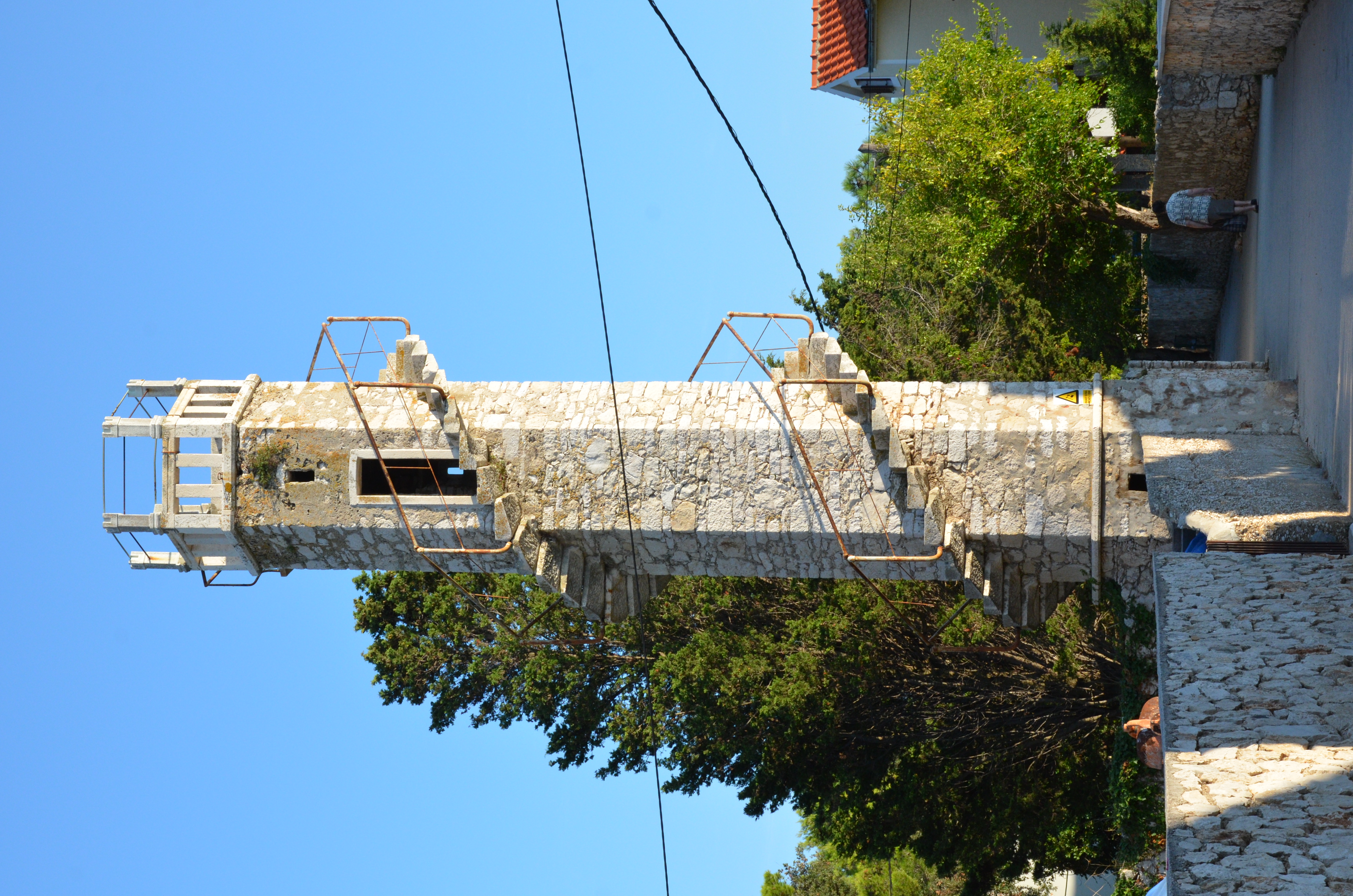
One of the symbols of Silba is the "Torretta Marinich", a hexagonal observation tower, 15 m high, with an external spiral staircase. It was built by the Podestà, Captain Pietro Marinich (1816-1897), in the garden of the family house built in 1872, then accompanied by the chapel consecrated in 1894. It is in the centre of the village right on Veli Put - Silba's High Street. The village has several cafés, four restaurants, a number of shops, post office and a local GP. From any point in the village it takes only around 10 min or less to walk to the nearest beach.
History
The old name for this island is Selbo. It's supposed to come from the Latin word "Silva", meaning "forest". The island Silba is mentioned in historical records in the 9th century. In 827, it belonged to the Zadar county. In 1073, in the last year of Petar Krešimir's reign, probably at the request of his sister Cika, the first nun of St. Maria in Zadar, the county donated the island to the monastery St. Maria, at the ceremony of sacrament of their church (some say this happened in 1027). Later, the island fell into the hands of the Venetian authorities, which sold it to captain Fani Soppe for 12,350 ducats.
It is not known how it later came into the ownership of Venetian family Morosini. Silba was held by family Morosini until the first quarter of 19th century. As it was too far to govern and receive tax on yield in nature they agreed with inhabitants of Silba in 1770 to receive each year 2000 Venetian lira in rent. Silbans called this rent četvrtina (quarter), as it amounted to a quarter of the land's yields, which is what serfs elsewhere also gave to their masters.
In 1838, for 28,500 Austrian lira, family Morosini sold the island to Marko Ragusin from Veli Lošinj, who returned wealthy from United States.
As Silbans paid rent to previous owner in currency, they assumed they will do the same to the new landowner, but since he lived in Lošinj, near to Silba, he refused and demanded a quarter of land's yield in crop. A lawsuit ensued which lasted for 13 years when Ragusin finally decided to sell the island to these same inhabitants who bought it, each paying proportionally to the size of their plot, in total 5,025 bavarian thalers. On 19 March 1852 ownership of the island by inhabitants was registered. It became the island's main holiday, day of St. Joseph.
In the 18th century Silba had a fleet 38 sailing boats with three masts called Manzere of 220 Mt and 60 sailing boats two masts called Kastrere of 63 Mt. The fleet was destroyed by the French at the beginning of the 19th century. The economic benefits to the island from sailing boats led to general well-being on the island. Old local saying says: "Silba zlatom siva, i u njoj se raj uživa", that is: "Silba shines with gold, on it heavenly enjoyment".
In the olden days there was a custom of "village king" elections. The king would get elected on St. Stephen's Day (26 December) and his rule would last until Three Kings (6 January). During his twelve-day rule, he would preside, with crown on his head, surrounded by twelve councillors, over village gatherings and dealt justice. His task was to name the village head, head and members of village guards; close the previous years budget and plan the next years. He would give verdict on complaints and disputes that have accumulated during the year. This custom died out in the first quarter of the 19th century. The king's crown still exists in the treasury of the parish church.[3]
In 1943 Silba was the scene of a naval action during the Adriatic Campaign of World War II.
References
- Duplančić Leder, Tea; Ujević, Tin; Čala, Mendi (June 2004). "Coastline lengths and areas of islands in the Croatian part of the Adriatic Sea determined from the topographic maps at the scale of 1 : 25 000" (PDF). Geoadria. Zadar. 9 (1): 5–32. doi:10.15291/geoadria.127. Retrieved 2019-12-01.
- "Popis stanovništva 2011".
- Jurić, Ljubimir. Silba (1910) (reprint 1991: Društvo za zaštitu prirode Silba)
External links
- Silba Tourist Office
- Silba Tourist Office - old site
- Silba Online
- Silba - information & photos (in Croatian, English, German, Italian, French and Spanish)
| ||
Authority control | |
|---|---|
| General |
|
| National libraries | |
На других языках
[de] Silba
Silba (italienisch Selve) ist eine von 18 bewohnten Inseln des Zadarer Archipels in Kroatien. Sie liegt am Ende des südlichen Abschnitts des Kvarnerić zwischen den Inseln Premuda, Olib, Ilovik und Lošinj.- [en] Silba
[fr] Silba
Silba (en italien, Selve), est une localité de la municipalité de Zadar et une petite île du nord de la Dalmatie dans le Détroit de Zadar (en croate Zadarski kanal), au sud du Petit Kvarner (en croate Kvarnerić) dans la mer Adriatique et en face de l'île de Pag.[it] Selve
Selve[1][2][3][4][5][6][7] (in croato Silba) è un'isola della Croazia situata tra Premuda e Ulbo, a ovest di Pago.[ru] Силба
Си́лба (хорв. Silba) — остров в Хорватии, в северной части Адриатического моря. Остров расположен к северо-западу от Задара. К северу от острова находится залив Кварнер, к югу — залив «Вирско море». К востоку от Силбы лежит остров Олиб, к северо-западу — Лошинь, к западу — Премуда, а к югу — группа небольших островов, за которыми начинается Дуги-Оток.Другой контент может иметь иную лицензию. Перед использованием материалов сайта WikiSort.org внимательно изучите правила лицензирования конкретных элементов наполнения сайта.
WikiSort.org - проект по пересортировке и дополнению контента Википедии