geo.wikisort.org - River
The Palu River (Indonesian: Sungai Palu) is a river in Central Sulawesi, Sulawesi island, Indonesia, about 1600 km northeast of the capital Jakarta.[2][3]
| Palu River Sungai Palu, Salo Paloe, Binangga Palu, Sungai Miu | |
|---|---|
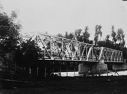
 Bridge over the Palu River (1930–1936) | |
| Location | |
| Country | Indonesia |
| Physical characteristics | |
| Source | |
| • location | Sulawesi |
| Mouth | |
• location | at Palu into Makassar Strait |
• elevation | Sea level |
| Basin size | 2,694 km2 (1,040 sq mi)[1] |
| Discharge | |
| • average | 61.2 m3/s (2,160 cu ft/s) |
| Basin features | |
| Tributaries | |
| • right | Gumbasa River |
Hydrology
The river flows through the city of Palu, with 41% of the basin area covered by the protected tropical montane forest of the Lore Lindu National Park.[4]
Geography
The river flows in the west area of Sulawesi with predominantly tropical rainforest climate (designated as Af in the Köppen-Geiger climate classification).[5] The annual average temperature in the area is 24 °C. The warmest month is October, when the average temperature is around 26 °C, and the coldest is July, at 22 °C.[6] The average annual rainfall is 2092 mm. The wettest month is August, with an average of 252 mm rainfall, and the driest is February, with 114 mm rainfall.[7]
| Palu River | ||||||||||||||||||||||||||||||||||||||||||||||||||||||||||||
|---|---|---|---|---|---|---|---|---|---|---|---|---|---|---|---|---|---|---|---|---|---|---|---|---|---|---|---|---|---|---|---|---|---|---|---|---|---|---|---|---|---|---|---|---|---|---|---|---|---|---|---|---|---|---|---|---|---|---|---|---|
| Climate chart (explanation) | ||||||||||||||||||||||||||||||||||||||||||||||||||||||||||||
| ||||||||||||||||||||||||||||||||||||||||||||||||||||||||||||
| ||||||||||||||||||||||||||||||||||||||||||||||||||||||||||||
See also
References
- "The impact of the warm phase of ENSO (El Nĩno Southern Oscillation) events on water resource availability of tropical catchments in Central Sulawesi, Indonesia" (PDF). Advances in Geosciences. 2006. Retrieved 2013-09-21.
- Rand McNally, The New International Atlas, 1993.
- Sungai Palu at Geonames.org (cc-by); Last updated 2013-06-04; Database dump downloaded 2015-11-27
- "The Impact of El Niño Southern Oscillation Events on Water Resource Availability in Central Sulawesi, Indonesia" (PDF). Constanze Leemhuis. 2005. Retrieved 2013-09-21.
- Peel, M C; Finlayson, B L; McMahon, T A (2007). "Updated world map of the Köppen-Geiger climate classification". Hydrology and Earth System Sciences. 11 (5): 1633–1644. doi:10.5194/hess-11-1633-2007. Retrieved 30 January 2016.
- "NASA Earth Observations Data Set Index". NASA. 30 January 2016.
- "NASA Earth Observations: Rainfall (1 month – TRMM)". NASA/Tropical Rainfall Monitoring Mission. 30 January 2016.
На других языках
[de] Palu (Fluss)
Der Palu (indonesisch Sungai Palu) ist ein Fluss auf der indonesischen Insel Sulawesi. Er mündet bei der Stadt Palu (Provinz Zentralsulawesi) in die Bucht von Palu. Über seiner Mündung führte bis 2018 Sulawesis älteste Bogenbrücke, die Jembatan Palu IV. Sie wurde nach dem Sulawesi-Erdbeben 2018 von einem drei Meter hohen Tsunami zerstört.[1] Weiter flussaufwärts führt die Hängebrücke Jembatan Gantung über den Palu.- [en] Palu River
Другой контент может иметь иную лицензию. Перед использованием материалов сайта WikiSort.org внимательно изучите правила лицензирования конкретных элементов наполнения сайта.
WikiSort.org - проект по пересортировке и дополнению контента Википедии

