geo.wikisort.org - River
The Moyo River is a river of Sumbawa, West Nusa Tenggara province, Indonesia, about 1200 km east of capital Jakarta.[1][2]
| Moyo River Brang Moyo, Sungai Brang Moyo, Brang Mojo, Mojo River | |
|---|---|
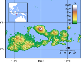 Location of the mouth  Moyo River (Indonesia) | |
| Location | |
| Country | Indonesia |
| Physical characteristics | |
| Source | |
| • location | Sumbawa |
| Mouth | |
• location | West Nusa Tenggara |
Geography
The river flows along the northwestern area of Sumbawa with predominantly tropical savanna climate (designated as As in the Köppen-Geiger climate classification).[3] The annual average temperature in the area is 26 °C. The warmest month is October, when the average temperature is around 30 °C, and the coldest is February, at 24 °C.[4] The average annual rainfall is 1456 mm.. The wettest month is January, with an average of 294 mm rainfall, and the driest is August, with 19 mm rainfall.[5]
See also
References
- Rand McNally, The New International Atlas, 1993.
- Brang Moyo at Geonames.org (cc-by); Database dump downloaded 27 November 2015
- Peel, M C; Finlayson, B L; McMahon, T A (2007). "Updated world map of the Köppen-Geiger climate classification". Hydrology and Earth System Sciences. 11 (5): 1633–1644. Bibcode:2007HESS...11.1633P. doi:10.5194/hess-11-1633-2007.
- "NASA Earth Observations Data Set Index". NASA. 30 January 2016.
- "NASA Earth Observations: Rainfall (1 month – TRMM)". NASA/Tropical Rainfall Monitoring Mission. 30 January 2016.
Текст в блоке "Читать" взят с сайта "Википедия" и доступен по лицензии Creative Commons Attribution-ShareAlike; в отдельных случаях могут действовать дополнительные условия.
Другой контент может иметь иную лицензию. Перед использованием материалов сайта WikiSort.org внимательно изучите правила лицензирования конкретных элементов наполнения сайта.
Другой контент может иметь иную лицензию. Перед использованием материалов сайта WikiSort.org внимательно изучите правила лицензирования конкретных элементов наполнения сайта.
2019-2026
WikiSort.org - проект по пересортировке и дополнению контента Википедии
WikiSort.org - проект по пересортировке и дополнению контента Википедии