geo.wikisort.org - River
Northeast Branch Anacostia River is a 3.2-mile-long (5.1 km)[1] free-flowing stream in Prince George's County, Maryland. It is a tributary of the Anacostia River, which flows to the Potomac River and the Chesapeake Bay.
| Northeast Branch Anacostia River | |
|---|---|
 | |
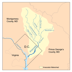 Map of the Anacostia River watershed showing the Northeast Branch | |
| Location | |
| Country | United States |
| State | Maryland |
| Cities | Beltsville, Greenbelt, College Park, Hyattsville |
| Physical characteristics | |
| Source | Paint Branch |
| • location | Maryland |
| • coordinates | 38.9786111°N 76.9169444°W |
| Source confluence | College Park |
| Mouth | Anacostia River |
• location | Bladensburg |
• coordinates | 38.9426111°N 76.9435856°W |
| Length | 3 mi (4.8 km) |
| Basin size | 75.6 sq mi (196 km2) |
| Basin features | |
| Tributaries | |
| • left | Brier Ditch |
Course
The headwaters of the Northeast Branch are at the confluence of Indian Creek and Paint Branch, located on the eastern edge of the community of College Park. The stream flows southward for about 3 miles (5 km) to its confluence with the Northwest Branch near Bladensburg to form the mainstem of the Anacostia.
Watershed
The Northeast Branch watershed in Prince George's County includes portions of the communities of Beltsville, Greenbelt, College Park, New Carrollton, Riverdale Park, Hyattsville, Berwyn Heights and Edmonston. Portions of the Paint Branch and Little Paint Branch tributaries also drain the Cloverly, Colesville, Fairland, White Oak and Hillandale communities in Montgomery County. Major institutions in the watershed include the Beltsville Agricultural Research Center, University of Maryland, College Park and Greenbelt Park. The total watershed area, including tributaries, is 75.6 square miles (196 km2), with a resident population of about 246,530.[2]
Geology
Northeast Branch is located in the Atlantic coastal plain geologic region.
Tributaries
The total stream channel length of Northeast Branch and all tributaries is 12.1 miles (19.5 km).[3]: 20
- Brier Ditch
- Indian Creek
- Little Paint Branch
- Paint Branch
- Still Creek
- Upper Beaverdam Creek
Crossings
See also
- List of Maryland rivers
- Anacostia Tributary Trails
References
- U.S. Geological Survey. National Hydrography Dataset high-resolution flowline data. The National Map, accessed August 15, 2011
- Anacostia Watershed Restoration Partnership. "Northeast Branch."[permanent dead link] Accessed 2009-12-21.
- Anacostia Watershed Restoration Partnership (2008). "Anacostia River Watershed Restoration Plan: Interim Report Framework, September 2007–November 2008."[permanent dead link] Report to Congress.
- Maryland Department of Natural Resources, Annapolis, MD (2005). "Characterization of the Anacostia River Watershed in Prince George’s County, Maryland."
- Montgomery County Department of Environmental Protection (MCDEP), Rockville, MD (1997). "Little Paint Branch Watershed Study."
- MCDEP (1998). "Countywide Stream Protection Strategy: Paint Branch Watershed."
External links
- Anacostia Watershed Society - Detailed maps and photos of stream conditions
- Anacostia Watershed Restoration Partnership
- Anacostia Tributary Trail System - Prince George's County Dept. of Parks & Recreation
Другой контент может иметь иную лицензию. Перед использованием материалов сайта WikiSort.org внимательно изучите правила лицензирования конкретных элементов наполнения сайта.
WikiSort.org - проект по пересортировке и дополнению контента Википедии