geo.wikisort.org - River
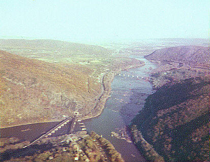
The Shenandoah River /ˌʃɛnənˈdoʊə/ is the principal tributary of the Potomac River, 55.6 miles (89.5 km) long with two forks approximately 100 miles (160 km) long each,[3] in the U.S. states of Virginia and West Virginia. The river and its tributaries drain the central and lower Shenandoah Valley and the Page Valley in the Appalachians on the west side of the Blue Ridge Mountains, in northwestern Virginia and the Eastern Panhandle of West Virginia.[1] There is a hydroelectric plant along the Shenandoah river constructed in 2014 by Dominion.
| Shenandoah River | |
|---|---|
 Crossing the Shenandoah River in Harpers Ferry, West Virginia | |
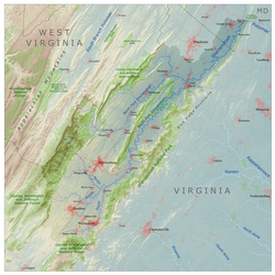 Shenandoah River drainage basin | |
| Location | |
| Country | United States |
| State | Virginia, West Virginia |
| Towns | Harper's Ferry, WV, Front Royal, VA, Luray, VA |
| Physical characteristics | |
| Source | North Fork |
| • location | Shenandoah Mountain |
| 2nd source | South Fork |
| • location | Port Republic |
| Source confluence | |
| • location | Front Royal, VA |
| Mouth | Potomac River |
• location | Harpers Ferry |
• coordinates | 39.3226009°N 77.7277704°W[1] |
• elevation | 246 ft (75 m)[1] |
| Length | 56 mi (90 km) |
| Basin size | 2,937 sq mi (7,610 km2) |
| Discharge | |
| • location | Millville, WV[2] |
| • average | 2,755 cu ft/s (78.0 m3/s) |
| Basin features | |
| Tributaries | |
| • left | North Fork (Shenandoah River) |
| • right | South Fork (Shenandoah River) |
Course
The Shenandoah River is formed northeast of Front Royal near Riverton, by the confluence of the South Fork and the North Fork. It flows northeast across Warren County, passing underneath Interstate 66 1 mile (1.6 km) from its formation. Beyond the I-66 bridge the river flows through a set of bends before turning to the northeast again, crossing into Clarke County 11 miles (18 km) below I-66. Five miles (8 km) downriver from the Clarke County border, the Shenandoah passes under U.S. Route 50 and then passes through a triple bend. 14.5 miles (23.3 km) below the Route 50 bridge, the river passes underneath State Route 7 and then continues northeast another 8 miles (13 km) where it crosses into Jefferson County in West Virginia. Once in West Virginia the river completes six large bends before joining with the Potomac from the southwest near Harpers Ferry. The confluence is on the West Virginia-Maryland border and 0.4 miles (0.64 km) from the Virginia-West Virginia border.[4]
Geology

The Shenandoah Valley is underlaid by limestone. The fertile soil made it a favored place for early settlement. It continues to be a major agricultural area of Virginia and West Virginia. Some karst topography is evident, and the limestone is honeycombed with caves. Several have been developed as commercial tourist attractions, including Luray Caverns, Shenandoah Caverns, and Skyline Caverns.
On the riverbank a few miles above Harper's Ferry is said to be a cave with an opening just large enough for a mounted rider to squeeze through. It widened in the interior to a spacious room where hundreds of Col. John Mosby's raiding troops are said to have hidden from pursuing Union cavalry.[5]
Environmental issues
Since 2005, the Shenandoah River has experienced several springtime fish kills that have affected several of its native fish species. In 2005, redbreast sunfish and smallmouth bass along a 100-mile (160 km) stretch of the South Fork Shenandoah River began dying of lesions caused by bacteria and fungi. Although the fish kill eventually wiped out 80% of the adult redbreast sunfish and smallmouth bass, juvenile populations appeared to be unaffected.[6] The following year more-localized fish kills in Clarke County spread to two of the Shenandoah's three species of sucker: the shorthead redhorse and the northern hogsucker – the former suffering from similar lesions witnessed in the previous year's fish kill.[7] Virginia's Department of Environmental Quality received reports of fish kills near Elkton and between Bentonville and Front Royal in late April 2007 and observed fish exhibiting lesions and strange behavior.[8]
Etymology
![Moonlight on the Shenandoah, engraving by J.D. Woodward[9]](http://upload.wikimedia.org/wikipedia/commons/b/b6/Wd.shenandoah.jpg)
Various accounts tell the origin of the name. According to one, General George Washington named the valley (and river) in honor of Skenandoa (or Shenandoah), an Oneida "pine tree chief" based in New York, who led hundreds of Oneida and Tuscarora warriors in support of the American rebels on the frontier during the Revolutionary War. He also sent much needed corn to Washington and his troops during their hard winter at Valley Forge, Pennsylvania in 1777–1778.[10][11] However, the name was in use when Washington was a child, as evidenced in land grants and correspondence.[12] It is also said to be named after the Senedo people, a little-documented tribe said to have lived on the north fork of the river and destroyed by the Catawba, some time between 1650 and 1700.
Recreation
The Shenandoah River is a very popular river for canoeing, river tubing, and white-water recreation such as rafting and kayaking (class I-III in season, II-III+ during the spring run-off), and several commercial outfitters offer a variety of guided trips and rentals.
South Fork Shenandoah River

The South Fork is formed at Port Republic in southern Rockingham County, by the confluence of the North River and South River. It flows 98.5 miles (158.5 km)[3] northeast in a tight meandering course, past Elkton and Shenandoah, through Page Valley, with the Blue Ridge Mountains to the east and the Massanutten Mountain range to the west.
South Fork tributaries
- North River
- South River
- Back Creek
- Overall Run
- Gooney Creek
Bridges over the South Fork
- N Shenandoah Avenue (US 340/ US 522/ Va 55)
- Rivermont Drive (SR 619)
- Indian Hollow Road (SR 613)
- Bixlers Ferry Road (SR 675)
- Lee Highway (US 211/ US 340)
- US 340 BUS
- US 340
- Maryland Avenue (SR 602)
- Old Spotswood Trail (US 33 BUS)
- Spotswood Trail (US 33)
- Island Ford Road (SR 649)
- Lynnwood Road (SR 708)

North Fork Shenandoah River
The North Fork is 105 miles (169 km) long[3] and rises in northern Rockingham County, along the eastern flank of Shenandoah Mountain in the George Washington National Forest. At its formation, the principal feeder on the North Fork is the German River. The North Fork flows initially southeast, down from the mountains, then northeast through a valley across Shenandoah County, along the western side of Massanutten Mountain. It flows past Woodstock and Strasburg. On the north end of the ridge it turns briefly southeast to join the South Fork from the northwest to form the Shenandoah.
North Fork tributaries
- German River
- Cedar Creek
- Smith Creek
- Toms Brook
- Passage Creek
- Linville Creek
- Shoemaker River
- Little Dry River
- Turley Creek
- Runions Creek
Bridges over the North Fork
- Winchester Road (US 340)
- Strasburg Road (Va 55)
- Deer Rapids Road (SR 744)
- Colby Lane (low-water, on private property)
- Bear Paw Road
- Headly Road (SR 600)
- Hesley Bridge Lane
- Artz Road (SR 663)
- Woodstock Tower Road (SR 758)
- South Hollingsworth Road (SR 609)
- Laurel Hill Lane
- Edinburg Gap Road (SR 675)
- Palmyra Church Road (SR 698)
- Red Banks Road (SR T-698)
- Old Valley Pike (US 11)
- Wissler Road (SR 720)
- Caverns Road (SR 730)
- Interstate 81
- Quicksburg Road (SR 767)
- River Road (SR 728)
- Va 42
- Shenandoah Avenue (SR 1411)
- Spar Mine Road (SR 617)
- Brocks Gap Road (Va 259)
- Hopkins Gap Road (SR 612)
- Little Dry River Road (SR 818)
- Yankeetown Road
- Lairs Run Road
- Bergton Road (SR 820)
- Bergton Road (SR 820)
Shenandoah tributaries
West Virginia
- Hog Run
- Long Marsh Run
- Bullskin Run
- Evitts Run
- Forge Run
- Cattail Run
- Flowing Springs Run
- Stikeys Run
- Double Run
Virginia
- Happy Creek
- Manassas Run
- Venus Branch
- Long Branch
- Spout Run
- Morgan Mill Stream
- Chapel Run
- Lewis Run
- Craig Run
- Dog Run
- Spout Run
- Wheat Spring Run
- Passage Creek
In culture
The American folk song and sea chantey titled "Oh Shenandoah" has been adapted to explicitly reference the river or river valley, although earlier versions referred to the 18th century Oneida Chief Shenandoah and the Missouri River, 1,000 miles to the west.
The 1971 hit and signature song of John Denver, "Take Me Home, Country Roads", prominently mentions the Shenandoah River, and was adopted by the state of West Virginia in 2014 as its fourth official state song.
See also
- List of Virginia rivers
- List of West Virginia rivers
References
- "Shenandoah River". Geographic Names Information System. United States Geological Survey, United States Department of the Interior.
- "USGS 01636500 Shenandoah at Millville, WV" (PDF). National Water Information System. U.S. Geological Survey. 1895–2013. Retrieved May 24, 2014.
- U.S. Geological Survey. National Hydrography Dataset high-resolution flowline data. The National Map, accessed August 15, 2011
- Harpers Ferry, West Virginia, 7.5 Minute Topographic Quadrangle, USGS, 1996
- Virgil Carrington Jones, Mosby's Rangers (Chapel Hill & University of North Carolina Press, 1944), p. 240 (The Union discovered Mosby's cave only by accident late in the war when a wandering horse fell through a trap door hidden in a burnt-out house on the bluff above the river. A curious Union soldier noticed stairs leading downward, which proved to be the second entrance to the cave. There were stalls, hay, and room enough for 100 to 300 horses).
- Michael Alison Chandler (July 20, 2005). "Troubled Waters in the Shenandoah". The Washington Post. Retrieved March 29, 2015.
- Trice, Calvin R. (June 7, 2006). "Shenandoah fish kill has afflicted more species". Richmond Times-Dispatch. Richmond, VA. p. B-1.
- Virginia Department of Environmental Quality. "Virginia Seeks Public's Help in Fish Kill Investigation". Deq.virginia.gov. Retrieved March 29, 2015.
- Woodward engraving reproduced from The Aldine Magazine, Vol. VI No. 7, July 1873
- ""Cultural Heritage: American Revolution", 5 July 2010, Oneida Tribe of Indians of Wisconsin". oneidanation.org.
- ""The Revolutionary War", 5 July 2010, Oneida Indian Nation". oneidaindiannation.com.
- http://image.lva.virginia.gov/LONN/LO-1/018/018_0109.tif [bare URL image file]
External links
- Virginia Department of Game and Inland Fisheries - South Fork
- Friends of the North Fork Shenandoah River
- Shenandoah Riverkeeper
Authority control | |
|---|---|
| National libraries | |
| Other | |
На других языках
[de] Shenandoah River
Der Shenandoah ist ein rechter Nebenfluss des Potomac River, etwa 241 Kilometer lang, in den US-Bundesstaaten Virginia und West Virginia. Als Hauptnebenfluss des Potomac entwässert er die seitlichen Täler der Appalachen westlich der Blue Ridge Mountains.- [en] Shenandoah River
[es] Río Shenandoah
El río Shenandoah es un afluente del Potomac de unos 90 km de longitud, que fluye en dirección noreste por el estado estadounidense de Virginia y en su último tramo forma frontera entre este estado y Virginia Occidental. Tiene dos fuentes, el North Fork y el South Fork de unos 100 km cada una. Fluye por el oeste de la cordillera Azul, en el noroeste de Virginia.[it] Shenandoah (fiume)
Lo Shenandoah è un fiume negli Stati Uniti d'America; affluente del fiume Potomac, è lungo 90 km, con due rami di circa 160 km ciascuno.[1] Scorre negli Stati della Virginia e della Virginia Occidentale. È il principale affluente del Potomac. Con i suoi affluenti, lo Shenandoah raccoglie le acque della parte centrale e inferiore della valle dello Shenandoah e della valle Page negli Appalachi, a ovest dei monti Blue Ridge, nella Virginia nordoccidentale e nel panhandle orientale della Virginia Occidentale.[ru] Шенандоа (река)
Шенандоа — река на востоке США, протекающая по штатам Виргиния и Западная Виргиния, приток реки Потомак.Другой контент может иметь иную лицензию. Перед использованием материалов сайта WikiSort.org внимательно изучите правила лицензирования конкретных элементов наполнения сайта.
WikiSort.org - проект по пересортировке и дополнению контента Википедии