geo.wikisort.org - River
Antietam Creek (/ænˈtiːtəm/) is a 41.7-mile-long (67.1 km)[1] tributary of the Potomac River located in south central Pennsylvania and western Maryland in the United States, a region known as the Hagerstown Valley. The creek became famous as a focal point of the Battle of Antietam during the American Civil War.
| Antietam Creek | |
|---|---|
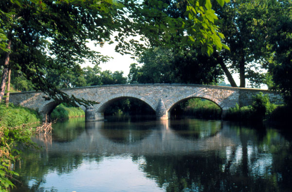 Burnside's Bridge traversing Antietam Creek near Sharpsburg, Maryland, site of heavy combat during the Battle of Antietam (Sharpsburg) on September 17, 1862 | |
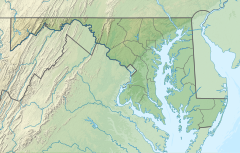 Location of mouth in Maryland | |
| Location | |
| Country | United States |
| States | Maryland, Pennsylvania |
| Physical characteristics | |
| Mouth | |
• coordinates | 39.4173220°N 77.7455486°W |
| Length | 41.7 mi (67.1 km) |
| Basin size | 290 km2 (110 sq mi) |
| Basin features | |
| River system | Potomac River |
Geography
The creek is formed in Franklin County, Pennsylvania, at the confluence of the West and East Branches of Antietam Creek, about 2.3 miles (3.7 km) south of Waynesboro, Pennsylvania. Welty's Mill Bridge crosses the East Branch of Little Antietam at Washington Township in Franklin County, Pennsylvania. The stream runs for about 0.5 miles (0.80 km) upon its entering Washington County, Maryland. The course proceeds southward in a meandering pattern, and the creek empties into the Potomac south of Sharpsburg[2] about 50 miles (80 km) upstream of Washington.[3]
The watershed area is 290 square miles (750 km2) and includes parts of Franklin County (106 mi2) and Washington County (185 mi2).[4]: 3 Major tributaries in Pennsylvania include the East and West Branches, Red Run and Falls Creek. Major tributaries in Maryland include Little Antietam Creek, Beaver Creek, and Marsh Run. Communities in the watershed include Waynesboro in Pennsylvania; and Boonsboro, Funkstown, Hagerstown, Mount Aetna, Sharpsburg and Smithsburg in Maryland.
At least four different tributaries are named Little Antietam Creek. Little Antietam Creek which empties into the Antietam in Keedysville, Maryland and another below Leitersburg, Maryland. The name Little Antietam Creek is also applied to the East and West Branch in Pennsylvania,[5][6] the West Branch historically Little Antietam Creek proper.[6] These names are listed in the United States Geological Survey as variants.
History

The term "Antietam" is thought to derive from an Algonquian phrase meaning "swift-flowing stream".[7] Historical and variant names include Andiedom, Andirton Creek, Ant-eat-em Creek, Anticturn Creek, Antieatum Creek, Crooked Brook, Odieta Creek and Ondieta Creek.[2]
The creek is noted for numerous well-preserved stone arch bridges dating to the 19th century that still traverse the creek, the most famous of which is the 125-foot-long (38 m) Burnside's Bridge in the Antietam National Battlefield.
The creek was a major topographic feature during the Battle of Antietam or Sharpsburg, fought on September 17, 1862, near the creek's mouth.[3] Burnside's Bridge became a major focus of combat as Union forces under General Ambrose Burnside repeatedly tried to capture the bridge from Confederate forces guarding the crossing from a high bluff overlooking the creek. The day of the battle is known as "the day Antietam Creek ran red" due to the blood of thousands of Union casualties mixing with the creek waters. Both sides lost about a fourth of their number[8] but, despite General McClellan's refusal to press on his attacks,[8] it served as a tactical Union victory, as Lee was forced to withdraw from Maryland.
Development and water quality issues
Most of the watershed area is relatively rural in nature, but the area surrounding Hagerstown is threatened by urban sprawl. The area is also heavily cultivated, and waste runoff from farms is a growing water quality concern. The Maryland Department of the Environment (MDE) has identified farm runoff as the largest source of sediment (loose soil) in Antietam Creek and its tributaries. The second largest source is urban runoff.[4]: 11 MDE recommends that farmers implement best management practices on their lands to control runoff, such as installing riparian buffers.[4]: 34
See also
- List of Maryland rivers
- List of Pennsylvania rivers
References
- U.S. Geological Survey. National Hydrography Dataset high-resolution flowline data. The National Map Archived 2012-03-29 at the Wayback Machine, accessed August 15, 2011
- United States Geological Survey. Reston, VA. "Antietam Creek." Geographic Names Information System (GNIS). Accessed 2010-04-27.
- EB (1878).
- Maryland Department of the Environment. Baltimore, MD (2008). "Total Maximum Daily Load of Sediment in the Antietam Creek Watershed, Washington County, Maryland." Archived 2011-09-27 at the Wayback Machine 2008-08-11.
- Geographic Names Information System. "GNIS entry for East Branch Antietam Creek (Feature ID # 1200079)". Retrieved 2020-03-12.
- Geographic Names Information System. "GNIS entry for West Branch Antietam Creek (Feature ID # 1190886)". Retrieved 2020-03-12.
- "Antietam". Online Etymology Dictionary. Retrieved 4 April 2011.
- EB (1911).
Bibliography
- Baynes, T. S., ed. (1878), , Encyclopædia Britannica, vol. 2 (9th ed.), New York: Charles Scribner's Sons, p. 127
- Chisholm, Hugh, ed. (1911), , Encyclopædia Britannica, vol. 2 (11th ed.), Cambridge University Press, p. 124
External links
- Antietam Creek Watershed Alliance (Hagerstown area)
- Antietam Watershed Association (Waynesboro area)
- Battle of Antietam
| Authority control: National libraries |
|---|
На других языках
[de] Antietam Creek
Der Antietam Creek ist ein 67,7 km langer Nebenfluss des Potomac River im sogenannten Hagerstown Valley im Osten der Vereinigten Staaten. Berühmtheit erlangte der Fluss durch die Schlacht am Antietam.- [en] Antietam Creek
[es] Antietam Creek
Antietam Creek (creek se traduce al español como riachuelo) es un afluente del río Potomac situado en el centro-sur del estado de Pensilvania y en la región conocida como Hagerstown Valley, al oeste de Maryland, en los Estados Unidos. El riachuelo se hizo famoso al ser el lugar donde se produjo la batalla de Antietam durante la Guerra Civil Estadounidense. Se cree que el nombre "Antietam" proviene de una frase nativa que significaba "riachuelo que fluye veloz".Другой контент может иметь иную лицензию. Перед использованием материалов сайта WikiSort.org внимательно изучите правила лицензирования конкретных элементов наполнения сайта.
WikiSort.org - проект по пересортировке и дополнению контента Википедии