geo.wikisort.org - River
Marshyhope Creek is a 37.0-mile-long (59.5 km)[8] tributary of the Nanticoke River on the Delmarva Peninsula. It rises in Kent County, Delaware, and runs through Caroline County, Maryland, and Dorchester County, Maryland.
| Marshyhope Creek Tributary to Nanticoke River | |
|---|---|
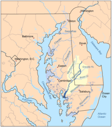 Map of the rivers of the Eastern Shore of Maryland with the Nanticoke and its watershed highlighted and showing Marshyhope Creek. | |
| Location | |
| Country | United States |
| State | Delaware Maryland |
| Counties | Kent (DE) Sussex (DE) Caroline (MD) Dorchester (MD) |
| Physical characteristics | |
| Source | divide between Marshyhope Creek and Murderkill River |
| • location | Minners Corners, Delaware |
| • coordinates | 38°55′18″N 075°38′27″W[1] |
| • elevation | 60 ft (18 m)[2] |
| Mouth | Nanticoke River |
• location | Walnut Landing, Maryland |
• coordinates | 38°31′38″N 075°45′24″W[3] |
• elevation | 0 ft (0 m)[4] |
| Length | 41.74 mi (67.17 km)[5] |
| Basin size | 41.74 square miles (108.1 km2)[6] |
| Discharge | |
| • average | 253.65 cu ft/s (7.183 m3/s) at mouth with Nanticoke River[7] |
| Basin features | |
| Progression | Nanticoke River → Chesapeake Bay → Atlantic Ocean |
| River system | Nanticoke River |
| Tributaries | |
| • left | Black Arm Prong Prospect Branch Tomahawk Branch Quarter Branch Double Fork Stafford Ditch Iron Mine Branch Jones Mill Branch Jones Branch Houston Branch Twiford Meadow Ditch Tanyard Branch Miles Branch Davis Millpond Branch Puckum Branch Becky Taylor Branch Messick Ditch |
| • right | Beaverdam Branch Green Branch Cattail Branch Short and Hall Branch Tommy Wright Branch Sullivan Branch Faulkner Branch Wrights branch Mill Creek Spears Creek Big Indian Creek Beach Branch Stony Bar Creek Big Creek |
Marshyhope Creek begins in southwestern Kent County, Delaware, near the city of Harrington, and ends at the Nanticoke River, near Sharptown, Maryland. The entire watershed is in the coastal plain and reaches sea level at Federalsburg, The head of navigation.
There are several small creeks on the western shore, including Faulkner Branch, Sullivan Branch, Capital Branch, Green Branch, and Horsepen Arm. On the eastern shore the small creeks include Tanyard Branch, Houston Branch, Jones Mill Branch, Double Fork Branch, Quarter Branch, Tomahawk Branch, and Prospect Point Branch.
See also
References
- "GNIS Detail - Marshyhope Creek". geonames.usgs.gov. US Geological Survey. Retrieved 30 July 2019.
- "Marshyhope Creek Topo Map, Dorchester County MD (Rhodesdale Area)". TopoZone. Locality, LLC. Retrieved 30 July 2019.
- "GNIS Detail - Marshyhope Creek". geonames.usgs.gov. US Geological Survey. Retrieved 30 July 2019.
- "Marshyhope Creek Topo Map, Dorchester County MD (Rhodesdale Area)". TopoZone. Locality, LLC. Retrieved 30 July 2019.
- "ArcGIS Web Application". epa.maps.arcgis.com. US EPA. Retrieved 30 July 2019.
- "Marshyhope Creek Watershed Report". Waters Geoviewer. US EPA. Retrieved 30 July 2019.
- "Marshyhope Creek Watershed Report". Waters Geoviewer. US EPA. Retrieved 30 July 2019.
- U.S. Geological Survey. National Hydrography Dataset high-resolution flowline data. The National Map Archived 2012-03-29 at the Wayback Machine, accessed April 1, 2011
- United States Geological Survey. 7.5 minute series topographic quadrangles
Другой контент может иметь иную лицензию. Перед использованием материалов сайта WikiSort.org внимательно изучите правила лицензирования конкретных элементов наполнения сайта.
WikiSort.org - проект по пересортировке и дополнению контента Википедии