geo.wikisort.org - River
The Anacostia River /ænəˈkɒstiə/ is a river in the Mid Atlantic region of the United States. It flows from Prince George's County in Maryland into Washington, D.C., where it joins with the Washington Channel to empty into the Potomac River at Buzzard Point. It is about 8.7 miles (14.0 km) long.[3] The name "Anacostia" derives from the area's early history as Nacotchtank, a settlement of Necostan or Anacostan Native Americans on the banks of the Anacostia River.
| Anacostia River | |
|---|---|
 Anacostia River adjacent to the United States National Arboretum | |
 Anacostia River Watershed | |
| Location | |
| Country | United States |
| State | Maryland, District of Columbia |
| Physical characteristics | |
| Source | |
| • location | Bladensburg, Maryland |
| • coordinates | 38°56′33″N 76°56′38″W |
| Mouth | Potomac River |
• location | Washington, D.C. |
• coordinates | 38°51′13″N 77°01′13″W |
• elevation | −3 ft (−0.91 m)[1] |
| Length | 8.4 mi (13.5 km) |
| Basin size | 176 sq mi (460 km2) |
| Discharge | |
| • location | mouth |
| • average | 216.93 cu ft/s (6.143 m3/s) (estimate)[2] |
| Basin features | |
| Tributaries | |
| • left | Northeast Branch |
| • right | Northwest Branch |
Heavy pollution in the Anacostia and weak investment and development along its banks made it "D.C.'s forgotten river".[4] More recently, however, private organizations; local businesses; and the D.C., Maryland, and federal governments have made efforts to reduce pollution and protect the ecologically valuable Anacostia watershed.
Course
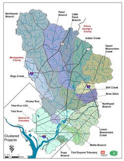
The main stem of the Anacostia is formed by the confluence of the Northwest Branch and the Northeast Branch just north of Cottage City, Maryland. Tributaries of these sources include Sligo Creek, Paint Branch, Little Paint Branch, Indian Creek, Upper Beaverdam Creek, Dueling Branch, and Brier's Mill Run. Tributaries of the main stem Anacostia include Watts Branch, Lower Beaverdam Creek, and Hickory Run.
Watershed
The watershed of the river covers roughly 176 sq mi (460 km2) in eastern Montgomery County and northern Prince George's County, as well as most of the eastern half of Washington, D.C.
History
Captain John Smith recorded in his journals that he sailed up the "Eastern Branch" or Anacostia River, in 1608 in his search for the main branch of the Potomac River and was well received by the Anacostans. On earlier maps, the river was known as the "Eastern Branch of the Potomac River" until it received its current, official name. In the mid-1600s, the name "Annacostin River" was applied to the stretch of the Potomac River north of Oxon Creek up to the vicinity of present-day Washington where the confluence with the modern Anacostia (then called the Eastern Branch or St. Isidora's Creek) and St. James Creek formed a natural harbor called St. Thomas's Bay.[5][6]
The Washington City Canal operated from 1815 until the mid-1850s, initially connecting the Anacostia to Tiber Creek and the Potomac River; and later to the Chesapeake and Ohio Canal. The city canal fell into disuse in the late 19th century, and the city government covered over or filled in various sections.[7]

During the American Civil War, an extensive line of forts was constructed south of the river in order to prevent Confederate artillery from bombarding the Washington Navy Yard, which abuts the river.
Pollution
This section needs to be updated. The reason given is: status of WSSC lawsuit, EPA discharge permit and litter control system. (June 2017) |

One of the biggest problems facing the Anacostia River is raw sewage that enters the river and its tributaries. During rainstorms, the river receives discharges of untreated sewage due to the city's antiquated combined sewer system. The sewage creates a public health threat because of fecal coliform bacteria and other pathogens; it also impairs water quality and can create hypoxic conditions that lead to large fish kills.
According to Rianna Murray et al. and a study from the NOAA Office of Response and Restoration, many citizens living along the Anacostia River have been exposed to water pollution.[8][9] One study done on recreational exposure to pollution along the river showed that many people reported "exposure to water while canoeing, kayaking, rowing, rafting, and paddling, and members of this group also reported getting water in their mouth while recreating."[8] This exposure to polluted water has potential adverse effects on the health of individuals and their community.[8]
The Anacostia Watershed Society (AWS) sued the District of Columbia Water and Sewer Authority (DCWASA) in 1999 for allowing more than 2 billion US gallons (7,600,000 m3) of combined sewage and urban runoff (stormwater) to flow into the river via its antiquated combined sewer overflow system. In settling the lawsuit, WASA agreed to invest $140 million on pump station rehabilitation, pipe cleaning and maintenance and public notices of overflows.
In late 2004, AWS and other organizations announced plans to sue the Washington Suburban Sanitary Commission (WSSC), the sewage authority in Maryland, over similar problems with river contamination from the Maryland suburbs. According to WSSC, more than 4 million US gallons (15,000 m3) of raw sewage were released into Anacostia tributaries between January 2001 and June 2004.
Mitigation of sewage overflows
Under a stormwater discharge permit issued by the U.S. Environmental Protection Agency (EPA), the D.C. government is implementing a stormwater management program to improve water quality in the Anacostia.[10] The governments of Montgomery County and Prince George's County also operate stormwater management programs.[11][12]
In response to the litigation, in 2011 DCWASA began building a large system of sewage storage tunnels to reduce combined sewer overflow. Four deep storage tunnels next to the Anacostia and Potomac Rivers will reduce overflows to the Anacostia by 98 percent, and 96 percent system-wide. When completed, the system will comprise over 18 miles (29 km) of tunnels with a storage capacity of 157 million US gallons (590,000 m3).[13] The first segment of the tunnel system, 7 miles (11 km) in length, opened in 2018. The remaining segments of the storage system are scheduled for completion in 2023.[14] (The city's overall "Clean Rivers" project, projected to cost $2.6 billion, includes other components, such as reducing stormwater flows.)[15]
PCB contamination
Another large source of river pollution is the Washington Navy Yard, which is sited alongside the river and is believed to be a source of PCB contaminants in the river and sediment.[16]
Litter control

In May 2009, a Bandalong Litter Trap floating litter-control system was placed in the Watts Branch tributary of the Anacostia River as part of Mayor Adrian Fenty's "Green DC Agenda."[17] In its first year of operation, it removed more than 500 pounds (230 kg) of floatable litter per month from the river.[18]
Mussel project
Since 2018, thousands of mussels have been placed in the Anacostia in an effort to reduce the impact of urban runoff, PCBs, and microplastics on river water quality and overall river health. This effort has happened in conjunction with a movement to make the river a popular local water recreation site.[19]
Mussels, which are filter feeders, have a strong capability to clean water. The Anacostia Watershed Society estimates that the mussels have already purified 32 million gallons of water in the first year of this project.[20]
The pilot project began in 2018 when the Anacostia Watershed Society harvested 9,000 quarter-sized mussels and placed them in the river in protective baskets. In 2019, after 92% of the mussels survived the first year of the project, the D.C. Department of Energy and Environment (DOEE) gave the watershed society a $400,000 grant to put another 35,000 mussels in the river.[20] Half of this funding came from the federal government, and the other half came from a five cent tax on plastic bags in the District.[19]
This project came at an especially important moment for Anacostia River health, as the D.C. area weathered intense rain in 2018 which contributed to much sediment, waste, and organic material flowing into the river. River health has improved since, as noted in the watershed society's 2019 river report card. The Anacostia earned its second-best-ever grade in the 2019 State of the Anacostia Report Card, but still failed the evaluation, earning a 51 percent.[21]
Swimming or wading in the Anacostia became illegal in 1971. However, as of 2019, city officials are considering changing this law and building public river pools. DOEE Director Tommy Wells said, “I believe we will have swimming platforms in Washington, D.C. by 2025."[22]
Freshwater mussels have tougher meat than saltwater mussels, so local restaurants are unlikely to buy them. “Without commercial demand for freshwater mussels, funding for their restoration hinges on proof of their ability to save rivers," The Washington Post reported in 2019.[19]
Recreational amenities


The Bladensburg Waterfront Park, part of the Prince George's County Department of Parks and Recreation, currently occupies the banks of the Anacostia near Alternate Route 1.[23] The Port Towns Community Boathouse at the park is home to public boat and bike rentals, a public boat ramp and dock, as well as the rowing crews of the University of Maryland, The Catholic University of America, a community rowing school, and several local high schools.[24]
The Anacostia Riverwalk Trail (partially complete as of June 2016) connects Bladensburg Waterfront Park the Tidal Basin via 28 miles (45 km) of paved, shared-use path with connections and spurs to the National Arboretum, Kenilworth Aquatic Gardens, Nationals Park, Maine Avenue Fish Market, and other locations.[25]
Crossings
See also
- 11th Street Bridges
- Anacostia (neighborhood in Washington, DC)
- Frederick Douglass Memorial Bridge
- John Philip Sousa Bridge
- List of rivers of Washington, D.C.
- List of rivers of Maryland
- Whitney Young Memorial Bridge
References
- U.S. Geological Survey Geographic Names Information System: Anacostia River
- United States Environmental Protection Agency. "Watershed Report: Anacostia River". WATERS GeoViewer. Archived from the original on 2021-07-08. Retrieved 2021-07-08.
- U.S. Geological Survey. National Hydrography Dataset high-resolution flowline data. The National Map Archived 2012-03-29 at the Wayback Machine, Retrieved August 15, 2011
- "The history of the Anacostia River - The Washington Post". web.archive.org. 2022-07-14. Archived from the original on 2022-07-14. Retrieved 2022-07-14.
- Marye, William B. (1938). "The Annacostin Indian Fort: Appendix — Potomac River Called Annacostin River" (PDF). Maryland Historical Magazine. 33 (2): 145–148. Retrieved October 12, 2021 – via Archives of Maryland Online.
- "History". Barracks Row Main Street. Retrieved October 12, 2021.
-
- Heine, Cornelius W. (1953). "The Washington City Canal". Records of the Columbia Historical Society. 53–56: 1–27. JSTOR 40067664. Now called Historical Society of Washington, DC. Archived 2009-12-07 at the Wayback Machine
- Murray, Rianna; Wilson, Sacoby (April 29, 2015). "Should We Put Our Feet in the Water? Use of a Survey to Assess Recreational Exposures to Contaminants in the Anacostia River". Environmental Health Insights. 9 (Suppl 2): 19–27. doi:10.4137/EHI.S19594. PMC 4476373. PMID 26124665.
- "Study Reveals D.C. Community near Anacostia River Are Eating and Sharing Contaminated Fish | response.restoration.noaa.gov". response.restoration.noaa.gov. Retrieved 2020-05-29.
- District of Columbia. Department of the Environment (DDOE). August 17, 2007. 2007 Implementation Plan: District of Columbia NPDES Permit No. DC0000221 Municipal Separate Storm Sewer System. Archived 2008-02-27 at the Wayback Machine
- Montgomery County. Department of Environmental Protection. Rockville, MD. May 2003. Montgomery County's Commitment to Anacostia Watershed Restoration. Archived February 27, 2008, at the Wayback Machine
- Prince George's County Government. Upper Marlboro, MD. October 26, 2007. Prince George's County Announces Anacostia Initiatives.[permanent dead link] Press Release.
- "Clean Rivers Project". District of Columbia Water and Sewer Authority (DCWASA). Retrieved 2018-03-05.
- "DC Water's Anacostia River Tunnel beating all projections for a cleaner Anacostia". DCWASA. 2018-09-21.
- Clean Rivers Project News: Combined Sewer Overflow Control Activities (PDF) (Report). DCWASA. October 2011. Biannual Report.
- Farenthold, David A. (2008-06-17). "Waste-Deep in the Big Muddy". The Washington Post. Interactive map
- "DDOE: Bandalong Litter Trap". Retrieved 2016-06-06.
- Storm Water Systems Inc. (2011-03-28). "Bandalong Litter Trap™ Case Study: Washington, D.C.'s Anacostia River" (PDF) (Press release). Cleveland, Georgia. Retrieved 2016-06-03.
- Nirappil, Fenit (October 23, 2019). "Can tens of thousands of mussels help save the polluted Anacostia River?". The Washington Post.
- Pipkin, Whitney (October 24, 2019). "Can Thousands of Mussels Become Millions in the Anacostia?". Bay Journal.
- Anacostia Watershed Society. "2019 State of the Anacostia Report Card" (PDF). Anacostia Watershed Society.
- Fenston, Jacob (July 23, 2019). "Could We Be Swimming In D.C.'s Rivers Soon?". DCist. Archived from the original on October 28, 2019.
- Prince George's County Department of Parks and Recreation, Riverdale, MD. "Boating Information." Archived 2016-07-30 at the Wayback Machine Retrieved 2012-12-03.
- "The Boathouse - CUA Rowing". Retrieved 2016-06-03.
- "Anacostia Riverwalk Trail | Anacostia Waterfront Initiative". Archived from the original on 2016-06-09. Retrieved 2016-06-03.
- Anacostia Watershed Restoration Partnership (2008). "Anacostia River Watershed Restoration Plan: Interim Report Framework, September 2007–November 2008."[permanent dead link] Report to Congress. 2008-11-21.
- United States Geological Survey. Reston, VA. "Anacostia River." Geographic Names Information System (GNIS). Retrieved 2009-09-18.
External links
- Anacostia Riverkeeper
- Anacostia Watershed Society
- Anacostia Watershed Restoration Partnership
- Maryland Department of Natural Resources: Anacostia River Basin website
- Earth Conservation Corps website
- PBS.org: Bill Moyers Journal — Earth Conservation Corps
Authority control | |
|---|---|
| General |
|
| National libraries | |
| Other | |
На других языках
[de] Anacostia River
Der Anacostia River ist ein 13,5 km langer Fluss in den Vereinigten Staaten, der im Prince George’s County in Maryland entspringt und die Hauptstadt Washington, D.C. durchfließt, wo er in den Potomac River mündet.- [en] Anacostia River
[es] Río Anacostia
El río Anacostia es un río que fluye durante 13,50 kilómetros (8,40 millas) desde el Condado de Prince George (Maryland), Estados Unidos hacia la ciudad de Washington D. C. donde confluye con el canal de Washington, para llevar su agua al río Potomac en Hains Point. El nombre de Anacostia proviene del nombre histórico de Nacochtank, un asentamiento de indios nativos estadounidenses en las orillas del río Anacostia. El capitán John Smith escribió en sus diarios que navegó la "Rama Este" o río Anacostia en 1608 en su búsqueda de la rama principal del río Potomac y dice que fue bien recibido por los habitantes de la zona.[it] Anacostia (fiume)
L'Anacostia è un fiume della costa orientale degli Stati Uniti d'America, lungo 14 km.[1][ru] Анакостия (река)
Анакостия (англ. Anacostia) — река на северо-востоке Соединённых Штатов Америки, левый приток реки Потомак. Протекает по округу Принс-Джорджес в штате Мэриленд и впадает в Потомак в городе Вашингтоне. Длина реки составляет около 13,5 километра.Другой контент может иметь иную лицензию. Перед использованием материалов сайта WikiSort.org внимательно изучите правила лицензирования конкретных элементов наполнения сайта.
WikiSort.org - проект по пересортировке и дополнению контента Википедии