geo.wikisort.org - River
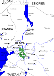
The Kerio River is a river in Turkana County, Kenya. It flows northward into Lake Turkana. It is one of the longest rivers in Kenya, originating near the equator.
| Kerio River | |
|---|---|
 Kerio River flowing after heavy spring rainstorms in the area | |
 River course | |
| Physical characteristics | |
| Source | |
| • coordinates | 0.528581°N 35.709643°E |
| Mouth | |
• coordinates | 2.956584°N 36.151543°E |
Course
The Kerio River rises on the north slopes of the Amasya Hills to the west of Lake Bogoria.[1] It flows northward through the Kerio Valley between Tugen Hills and Elgeyo Escarpment. The Elgeyo Escarpment rises to over 1,830 metres (6,000 ft) above the Kerio valley in places.[2] The Kerio continues northward, often through deep and narrow valleys, to enter Lake Turkana in a delta just south of the delta formed by the Turkwel and Lokichar rivers. The Kerio and Turkwel contribute 98% of the river water flowing into Lake Turkana on Kenyan territory (which makes up only 2% of the total riverine inflow). In their lower courses both these rivers are seasonal.[1]
Near its source the Kerio River is fed by two major tributaries flowing down Elgeyo Escarpment: Arror River, and Embobut River.
Land use
The Lake Kamnarok National Reserve and Kerio Valley National Reserve lie on the east and west sides of the Kerio River in the upper valley. They are undeveloped, but have abundant birdlife and are known for their scenery.[3] The left bank of a 25 kilometres (16 mi) section of the river is in the South Turkana National Reserve.[4]
In 1999 there were allegations that Fluorspar Mines was dumping toxic waste into the river. These were denied by the responsible Minister for Mineral Exploration.[5] The main locations in Turkana District for irrigated agriculture are along the Turkwel and Kerio rivers. The Lotubai and Morulem irrigation schemes are on the Kerio. The main crops are maize and sorghum, which account for 80% of irrigated crops, as well as green grams, cowpeas, bananas, mangoes, oranges and guavas.[6]
Gallery
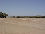 Kerio River during dry season. Riverbed is silty and easily erodes during storm events.
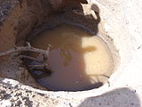 Hand dug well in riverbed.
 Kerio River flowing after heavy rainstorm.


See also
- Biretwo
- List of rivers of Africa
- Turkana people
References
- Hughes & Hughes 1992, p. 192.
- Fitzpatrick, Parkinson & Ray 2006, p. 430.
- Fitzpatrick, Parkinson & Ray 2006, p. 410.
- Hughes & Hughes 1992, p. 193.
- Kalweo 1999, p. 2754.
- Watson & van Binsbergen 2008, p. 16.
Sources
- Fitzpatrick, Mary; Parkinson, Tom; Ray, Nick (2006). East África. Lonely Planet. ISBN 1-74104-286-0.
- Hughes, R. H.; Hughes, J. S. (1992). A directory of African wetlands. IUCN. ISBN 2-88032-949-3.
- Kalweo (December 7, 1999). "Dumping of Toxins into River Keria". Parliamentary Debates.
- Watson, D.J.; van Binsbergen, J. (2008). Livelihood diversification opportunities for pastoralists in Turkana, Kenya. ILRI (aka ILCA and ILRAD). ISBN 978-92-9146-210-0.
| Authority control |
|
|---|
This Eastern Province (Kenya) location article is a stub. You can help Wikipedia by expanding it. |
На других языках
[de] Kerio
Der Kerio ist ein Fluss im Rift Valley. Er fließt nordwärts in den Turkana-See. Er ist einer der längsten Flüsse in Kenia und entspringt in Äquatornähe.- [en] Kerio River
[it] Kerio
Kerio è un fiume africano della provincia di Rift Valley in Kenya. Scorre verso nord nel lago Turkana. È uno dei maggiori fiumi del Kenya[ru] Керио (река, впадает в Рудольф)
Ке́рио (англ. Kerio) — река в Кении[1], берущая начало у экватора[2]. Течёт на север по территории округов Туркана, Эльгейо-Мараквет, Вест-Покот и Баринго. Впадает в озеро Туркана. Одна из самых длинных рек страны.Другой контент может иметь иную лицензию. Перед использованием материалов сайта WikiSort.org внимательно изучите правила лицензирования конкретных элементов наполнения сайта.
WikiSort.org - проект по пересортировке и дополнению контента Википедии