geo.wikisort.org - River
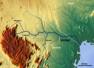
The Umba River is located in northeastern Tanzania in Tanga Region. It rises in Schageiuforest (Shagayu) in the West Usambara Mountains at 2,000 m altitude and flows on the north side of the mountain range to the east.[1] At Lelwa it empties the Mbalamu River, which comes from the extreme north of the Usambara Mountains, and the Mglumi River into the Umba. Just before the Umba flows into the Indian Ocean, it crosses the border to Kenya. The mouth itself marks the most eastern point on the border between Tanzania and Kenya, which was largely made in a straight line to the northwest towards Lake Victoria in the 19th Century. On the upper reaches of the river in the mid-1960s rich deposits of precious stones, including sapphires and spessartine, were discovered. Also on the river is the Umba River Game Reserve, a wildlife reserve that includes along with the Mkomazi Game Reserve, about 2,600 km².
| Umba River | |
|---|---|
 | |
| Location | |
| Country | Kenya |
| County | Kwale County |
| City | Lunga-Lunga |
| Country | Tanzania |
| Region | Tanga Region |
| Physical characteristics | |
| Source | |
| • location | Usambara Mountains, Tanzania |
| • elevation | 2,000 m (6,600 ft) |
| Mouth | |
• location | at Lunga-Lunga in the Indian Ocean, Tanzania |
• coordinates | 4°40′50″S 39°12′48″E |
• elevation | 0 m (0 ft) |
| Basin size | 7,130 km2 (2,750 sq mi) |
| Basin features | |
| Tributaries | |
| • left | Mglumi; Bombo |
| • right | Mbalamu |
Hydrometry
The flow of the river has been observed over 40 years (1963-2003) in Mbuta, a town about 40 km above the mouth.
The average monthly flow of the river Umba hydrological station of Mbuta (in m³ / s ) (calculated using the data for a period of 30 years, 1954–84)[2]

References
See also
- Geography of Tanzania
- Umba Valley
- Umba sapphires
На других языках
[de] Umba (Indischer Ozean)
Der Umba ist ein Fluss im Nordosten von Tansania in der Region Tanga.- [en] Umba River (Tanzania)
[es] Río Umba (Tanzania)
El río Umba se encuentra en el noreste de Tanzania, en la región de Tanga. Nace en el bosque de Schageiu (Shagayu), en las montañas Usambara occidentales, a 2.000 m de altitud, y fluye por el lado norte de la cordillera hacia el este.[1] En Lelwa desemboca en el río Mbalamu, que procede del extremo norte de los montes Usambara, y el río Mglumi. Justo antes de desembocar en el océano Índico, el Umba cruza la frontera con Kenia. La propia desembocadura marca el punto más oriental de la frontera entre Tanzania y Kenia, que en el siglo XIX se hizo en gran parte en línea recta hacia el noroeste, en dirección al lago Victoria. A mediados de la década de 1960 se descubrieron en el curso superior del río ricos yacimientos de piedras preciosas, como zafiros y espesartina. También en el río se encuentra la Reserva de Caza del Río Umba, una reserva de vida salvaje que incluye, junto con la Reserva de Caza de Mkomazi, unos 2.600 km².Другой контент может иметь иную лицензию. Перед использованием материалов сайта WikiSort.org внимательно изучите правила лицензирования конкретных элементов наполнения сайта.
WikiSort.org - проект по пересортировке и дополнению контента Википедии