geo.wikisort.org - River
Ruvuma River, formerly also known as the Rovuma River, is a river in the African Great Lakes region. During the greater part of its course, it forms the border between Tanzania and Mozambique (in Mozambique known as Rio Rovuma). The river is 800 kilometres (497 mi) long, with a drainage basin of 155,500 square kilometres (60,000 sq mi) in size. Its mean annual discharge is 475 m³/s (16,774 CFS) at its mouth.[1]
This article needs additional citations for verification. (February 2013) |
| Ruvuma Rovuma | |
|---|---|
 Ruvuma seen during Livingstone's second Zambesi expedition | |
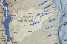 Map of the Ruvuma River drainage basin. | |
| Location | |
| Country | Tanzania, Mozambique |
| Physical characteristics | |
| Source | |
| • location | Ruvuma Region, Tanzania |
| • coordinates | 10°45′00″S 35°40′00″E |
| • elevation | 1,000 m (3,300 ft) |
| Mouth | |
• location | Indian Ocean |
• coordinates | 10°28′28″S 40°26′13″E |
| Length | 800 km (500 mi) |
| Discharge | |
| • average | 475 m3/s (16,800 cu ft/s) |
Overview
The lower Ruvuma river is formed by the junction at 11° 25' S., 38° 31' E. of two branches of nearly equal importance, the longer of which, the Lujenda, comes from the south-west, the other, which still bears the name Ruvuma, from the west. Its source lies on an undulating plateau, 1,000 m (3,300 ft) high, immediately to the east of Lake Nyasa, at 10° 45' S., 35° 40' E., the head-stream flowing first due west before turning south and east.
In its eastward course, the Ruvuma flows near the base of the escarpment of an arid sandstone plateau to the north, from which direction the streams, which have cut themselves deep channels in the plateau edge, have almost all short courses.
On the opposite bank the Ruvuma receives, besides the Lujenda, the Msinje River and Luchulingo River, flowing in broad valleys running from south to north. The Lujenda rises in proximity to Lake Chilwa, in the small Lake Chiuta (1,700 ft), the swamps to the south of this being separated from Chilwa only by a narrow wooded ridge. The stream which issues from Chiuta passes by a swampy valley into the narrow Lake Amaramba, from which the Lujenda River finally issues as a stream 80 yards wide.
Lower down it varies greatly in breadth, containing in many parts long wooded islands which rise above the flood level, and are often inhabited. The river is fordable in many places in the dry season. At its mouth it is about a mile wide.
The lower Ruvuma, which is often half a mile wide but generally shallow, flows through a swampy valley flanked by plateau escarpments containing several small backwaters of the river. The mouth is near 10° 28' S., 40° 30' E., the boundary near the coast being formed by the parallel of 10° 40'. The length of the Ruvuma is about 500 miles (800 km).
Bridge
A bridge called Unity Bridge across the river between Mozambique and Tanzania was proposed as early as 1975, and although construction was started, the project was abandoned due to lack of funds. In 2002 the two national governments made a formal agreement to build a new 600 metre bridge across the river, and this was finally opened in a ceremony on 25 May 2010. The bridge is located at Negomano, 200 km inland and 100 km from the nearest surfaced road in Mozambique. The site was agreed between Presidents Machel and Nyerere because this was the site of the first entry into Mozambique by Frelimo forces in the Mozambican War of Independence on 25 September 1964. Negomano was also the location where the German forces crossed the Rovuma river on 25 November 1917.[2] First foundation stones were laid on the Tanzanian and Mozambique sides on October 10th 2005. Construction was completed early 2010 and cost US$28 million. It used to be possible to cross the river with rafts (located at the Tanzanian side) that could carry 3 jeeps. The ferry sank in 2008 and has not been replaced. At low water the river is sometimes fordable with a good 4-wheel drive.
A smaller bridge called Unity Two was also completed in 2007 on the upper Rovuma close to Matchedge in Niassa Province.
Notes
- Nakayama, Mikiyasu (2003). International Waters in Southern Africa. United Nations University Press. p. 9. ISBN 92-808-1077-4.; online at Google Books
- Paice, Edward, 2008, Tip & Run, Phoenix, p. 339 ISBN 978-0753823491
References
This article incorporates text from a publication now in the public domain: Chisholm, Hugh, ed. (1911). "Rovuma". Encyclopædia Britannica. Vol. 23 (11th ed.). Cambridge University Press. p. 782.
На других языках
[de] Rovuma
Der Rovuma (andere Schreibweisen Ruvuma, Rowuma) ist ein etwa 760 km langer Fluss in Ostafrika.[1][2] In seinem Mittel- und Unterlauf bildet der Rovuma über eine Länge von rund 650 Kilometern die Grenze zwischen Tansania und Mosambik.- [en] Ruvuma River
[es] Río Ruvuma
El río Ruvuma (anteriormente conocido como Rovuma, como todavía es conocido en Mozambique) es un largo río del África oriental que discurre formando durante gran parte de su curso la frontera entre Tanzania y Mozambique. Tiene una longitud de unos 800 km, drena una amplia cuenca de 155 500 km² (mayor que países como Nepal o Bangladés) y tiene un caudal de 475 m³/s en su desembocadura.[1][it] Ruvuma (fiume)
Il Ruvuma (conosciuto anche con il nome di Rovuma) è un fiume dell'Africa orientale, tributario dell'oceano Indiano. Scorre per gran parte del suo corso delineando il confine tra gli Stati del Mozambico e della Tanzania.[ru] Рувума
Руву́ма[1] — река в Восточной Африке, большая часть реки образует границу между Танзанией и Мозамбиком[1].Другой контент может иметь иную лицензию. Перед использованием материалов сайта WikiSort.org внимательно изучите правила лицензирования конкретных элементов наполнения сайта.
WikiSort.org - проект по пересортировке и дополнению контента Википедии