geo.wikisort.org - River
The Save River, or Sabi River (Portuguese: Rio Save) is a 400 mi (640 km) river of southeastern Africa, flowing through Zimbabwe and Mozambique.[1][2] The river has its source in Zimbabwe, some 80 km (50 mi) south of Harare, then flows south and then east, from the Zimbabwean highveld to its confluence with the Odzi River. It then turns south, drops over the Chivirira (“Place of Boiling”) Falls, and flows down the western side of Zimbabwe's Eastern Highlands forming a dry river valley in the rain shadow of these mountains. It is joined by the Runde River or Lundi at the Mozambique border, forming a dramatic confluence at Mahenya. It then crosses Mozambique to flow into the Indian Ocean at about 21°S.
| Save River | |
|---|---|
 A view of the Save in Mozambique | |
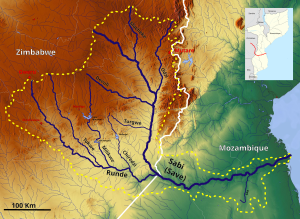 The Save Basin OSM | |
| Location | |
| Country | Zimbabwe, Mozambique |
| Physical characteristics | |
| Source | |
| • location | South of Harare, Zimbabwe |
| Mouth | |
• location | Indian Ocean |
| Length | 400 mi (640 km) |
| Basin size | 106,420 km2 (41,090 sq mi) |
The Save River provided irrigation for sugar plantation, but now supports the cultivation of citrus, cotton, rice, and wheat. It is also a source of small-scale fishing for the local population.[1][2]
It divides Mozambique administratively, politically, ethnically and ecologically:
- During the colonial era, the administrative units of the area south of the Save changed over time, but the longer lasting were the districts of Gaza and Inhambane; presently, the Save separates the provinces of Gaza and Inhambane to the south, from those of Manica and Sofala to the north:
- Politically, the “south-of-the-Save” can be considered the stronghold of Frelimo, while the region immediately to the north is, in general, more supportive of Renamo;
- The Save separates the ethnic groups that are native speakers of Shangaan (or Xi-Tsonga), to the south, from those that speak languages of the Shona group in the north;
- Ecologically, as the Save flows into the Indian Ocean, its mouth corresponds to the separation of tropical marine ecosystems, to the north, from the subtropical; the terrestrial ecosystems show less variation along the coastal plain north and south of the river, but inland where the Chimanimani Mountains start, a montane forest develops, which is completely different from the forests found in the south.
The delta of the Save River includes mangrove forests which span approximately 100 km (62 mi) on the Indian Ocean coast. Villagers in the delta basin use the mangrove forests for timber and as a place for small-scale fishing. The ecology of the lower Save River basin has been affected by cyclones, flooding, erosion, and sea level rise.[2]
Historically it was a transport route for gold and trade goods between the coast and the hinterland occupied by the civilisation of Great Zimbabwe in the 13th and 14th centuries AD.
References
- Sabi River
- Massuanganhe, Elídio A.; Macamo, Celia; Westerberg, Lars-Ove; Salomão, Bandeira; Mavume, Alberto; Ribeiro, Eunice (2015). "Deltaic coasts under climate-related catastrophic events – Insights from the Save River delta, Mozambique". Ocean & Coastal Management. Elsevier. 116: 331–340. doi:10.1016/j.ocecoaman.2015.08.008.
| Authority control |
|
|---|
На других языках
[de] Save (Straße von Mosambik)
Der Save (sprich: Sa'wie) ist einer der größeren Flüsse in Simbabwe und Mosambik.- [en] Save River (Africa)
[es] Río Save (África)
El río Save, o río Sabi, con una longitud de 644 km, es un río del sudeste de África, que fluye a través de Zimbabue y Mozambique. Nace en Zimbabue, a unos 80 km al sur de Harare, fluye hacia el sur y luego hacia el este, desde el Alto Veld de Zimbabue hasta su confluencia con el río Odzi. Luego gira hacia el sur, da lugar a las cataratas Chivirira y fluye por el lado occidental de las Tierras Altas Orientales de Zimbabue, en la zona seca de estas montañas. Se une con el río Runde o Lundi en la frontera con Mozambique. Luego cruza este país de oeste a este para desembocar en el Océano Índico a unos 21 °S.[it] Save (fiume africano)
Il fiume Save (o Sabi) è un fiume dell'Africa orientale. Nasce nello Zimbabwe, non molto distante dalla capitale Harare.[ru] Саве (река)
Саве[1], Саби[2] (порт. Save, англ. Sabi) — река в Юго-Восточной Африке. Длина реки 640 километров[3].Другой контент может иметь иную лицензию. Перед использованием материалов сайта WikiSort.org внимательно изучите правила лицензирования конкретных элементов наполнения сайта.
WikiSort.org - проект по пересортировке и дополнению контента Википедии