geo.wikisort.org - Reservoir
Lake Chiuta is a shallow lake on the border between Malawi and Mozambique. It lies to the north of Lake Chilwa and to the south of Lake Amaramba, which has no outlet, and the lakes are separated by a sandy ridge. Both lakes lie in a graben which runs northeast–southwest, east of the main African Rift Valley.
| Lake Chiuta | |
|---|---|
 Lake Chiuta | |
| Location | Malawi and Mozambique |
| Coordinates | 14°49′03″S 35°51′14″E |
| Type | lake |
| Surface area | 199 square kilometres (77 sq mi) |
| Average depth | 1.13 metres (3 ft 8 in) |
| Water volume | 0.225 cubic kilometres (0.054 cu mi) |
Lake Chiuta is 3–4 meters deep and ranges in size from 25 to 130 square kilometers, depending on the season and rainfall. Lake Chiuta and Amaramba is intermittently linked to the Lugenda River, a tributary of the Ruvuma River.
Lake Chiuta can desiccate completely (Owen et al. 198?)
Mean Depth: 1.13 metres (3 ft 8 in) / average surface area: 199 square kilometres (77 sq mi) / average volume: 0.225 cubic kilometres (0.054 cu mi) / encatchment area: 1,755 square kilometres (678 sq mi) (Ojda 1994)
Predominant commercial fish species are Oreochromis shiranus shiranus (Chambo), Clarias gariepinus (Mlamba), and Barbus paludinosus (Matemba). 37 fish species were recorded in total. (Ojda 1994)
Dominating aquatic macrophytes are Potamogeton welwitschii + Ceratophyllum demersum (submerged), Eleocharis dulcis, Oryza barthii, Vossia cuspidata, etc. (Ojda 1994)
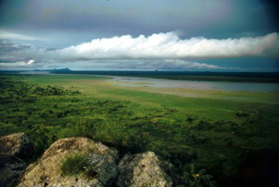
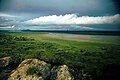 Lake Chiuta - northern tip
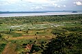 Lake Chiuta - middle part
 Lake Chiuta - Nafisi Inselbergs
 Lake Chiuta - fishermen viewed from Chiuta Isl.
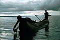 Lake Chiuta - checking gillnets
 Lake Chiuta - Chiuta Isl.
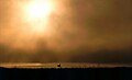 Lake Chiuta - unique atmosphere


References
- Dawson, A.L. (1970). "The Geology of the Lake Chiuta Area". Geological Survey Dept., Ministry of Natural Resources Malawi. Government Printer, Zomba, Malawi
- Owen, R.B & R. Crossley, 198?. "Recent sedimentation in Lakes Chilwa and Chiuta, Malawi". Dept. of Geography and Earth Science, University of Malawi, Zomba, Malawi
- Ojda, Lutz W. (1994). "Der Chiuta See in Malawi - Studie eines fluktuierenden tropischen Ökosystems mit Fokus auf dessen maximalen fischereilichen Dauerertrags (MSY) und seiner wirtschaftlichen Bedeutung für die angrenzende Kawinga-Ebene" (Monographie) Dissertation / Universität Hamburg / IHF
- Thieme, Michelle L. (2005). Freshwater Ecoregions of Africa and Madagascar: A Conservation Assessment. Island Press, Washington DC. pp. 173–175.
| Authority control |
|
|---|
На других языках
[de] Chiuta-See
Der Chiuta-See ist ein zur Provinz Niassa, Mosambik und zum größeren Anteil zum Distrikt Machinga, Malawi gehörender flacher See 20 Kilometer nördlich des Chilwa-Sees.- [en] Lake Chiuta
[fr] Lac Chiuta
Le lac Chiuta est un lac peu profond situé à la frontière entre le Malawi et le Mozambique. Il est au nord du lac Chilwa et au sud du lac Amaramba, qu'il alimente ; les deux lacs sont séparés par une crête sableuse. Ils se trouvent dans un graben orienté nord-est—sud-ouest, à l'est de la vallée du Grand Rift.[it] Lago Chiuta
Il lago Chiuta è un lago poco profondo al confine tra il Malawi e Mozambico. Si trova a nord del lago Chilwa e a sud del lago Amaramba, che non ha sbocco, ed i laghi sono separati da una cresta di sabbia. Entrambi i laghi si trovano in una fossa che corre a nordest-sudovest, a est della principale Rift Valley africana. Il lago Chiuta è profondo 3-4 metri e varia la sua estensione da 25 a 130 chilometri quadrati, a seconda della stagione e delle precipitazioni. I laghi Chiuta e Amaramba sono collegati in modo intermittente al fiume Lujenda, un affluente del fiume Ruvuma.[ru] Чиута (озеро)
Чиута — небольшое озеро на границе Малави и Мозамбика. Расположено к северу от озера Чилва и к югу от бессточного озера Амарамба (англ.) (рус.. Озера разделены песчаным хребтом. Оба озера находятся в грабене, который простирается с северо-востока на юго-запад, к востоку от Восточно-Африканской рифтовой долины.Другой контент может иметь иную лицензию. Перед использованием материалов сайта WikiSort.org внимательно изучите правила лицензирования конкретных элементов наполнения сайта.
WikiSort.org - проект по пересортировке и дополнению контента Википедии