geo.wikisort.org - River
The Kalambo River forms part of the border between Zambia and Songwe Region, Tanzania. It is a comparatively small stream which rises on the Ufipa Plateau north-east of Mbala at an elevation of about 1800 m and descends into the Albertine Rift, entering the southeastern end of Lake Tanganyika at an elevation of about 770 m, in a straight-line distance of only about 50 km.[citation needed] This accounts for its main claim to fame, its waterfall, Kalambo Falls, which is Africa's second highest falls (after South Africa's Tugela Falls). Below the falls, the river runs in a deep gorge.[citation needed]
| Kalambo River | |
|---|---|
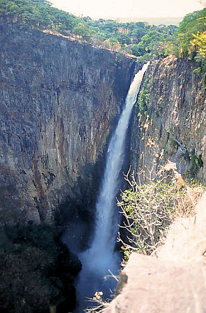 Kalambo Falls | |
| Location | |
| Country | Songwe Region, Tanzania |
| Country | Northern Province, Zambia |
| Physical characteristics | |
| Source | Ufipa Plateau |
| • location | Zambia |
| • elevation | 1,800 m (5,900 ft) |
| Mouth | Lake Tanganyika |
• location | Tanzania |
• elevation | 770 m (2,530 ft) |
| Length | 50 km (31 mi) |
For more details see Kalambo Falls, including coverage of the important archaeological sites discovered there.
References
- UNESCO, World Heritage Centre, Kalambo falls archaeological site (prehistoric settlement site), 11/06/1997.
- "Forestry." Encyclopædia Britannica. 2006. Encyclopædia Britannica Online. 17 June 2006 <http://search.eb.com/eb/article-26182>.
External links
- "Photo Gallery: Children enjoy a swim in Kalambo River at Kapozwa Village near Lake Tanganyika in Kalambo District, Rukwa Region". 2012. Archived from the original on 2012-09-04. Retrieved 2012-09-04.
Текст в блоке "Читать" взят с сайта "Википедия" и доступен по лицензии Creative Commons Attribution-ShareAlike; в отдельных случаях могут действовать дополнительные условия.
Другой контент может иметь иную лицензию. Перед использованием материалов сайта WikiSort.org внимательно изучите правила лицензирования конкретных элементов наполнения сайта.
Другой контент может иметь иную лицензию. Перед использованием материалов сайта WikiSort.org внимательно изучите правила лицензирования конкретных элементов наполнения сайта.
2019-2026
WikiSort.org - проект по пересортировке и дополнению контента Википедии
WikiSort.org - проект по пересортировке и дополнению контента Википедии