geo.wikisort.org - River
The Mara River is a river in that begins in Narok County (Kenya) and in ends in Mara Region (Tanzania), and lies across the migration path of ungulates in the Maasai Mara/Serengeti ecosystem.[citation needed]
This article needs additional citations for verification. (October 2008) |
| Mara River | |
|---|---|
 The Mara River in Kenya | |
 Mara River (bottom) | |
| Location | |
| Country | Kenya |
| County | Narok County |
| Country | Tanzania |
| Region | Mara Region |
| Physical characteristics | |
| Source | Mau escarpment |
| • location | Narok County, Kenya |
| • elevation | 3000 |
| Mouth | Lake Victoria |
• location | Mara Region, Tanzania |
• coordinates | 1°30′50″S 33°55′56″E |
| Length | 395 km (245 mi) |
| Basin size | 13,504 km2 (5,214 sq mi) |


The River's Flow
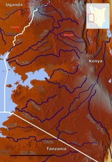
The Mara River basin covers a surface of 13,504 km2, of which approximately 65% is located in Kenya and 35% in Tanzania.[1] From its sources in the Kenyan highlands, the river flows for about 395 km and originates from the Mau Escarpment and drains into Lake Victoria. The basin can be roughly divided into four land use and/or administrative units.
The Mara's Regions
This section does not cite any sources. (May 2021) |
The Mau Escarpment: The Mara River originates from the Napuiyapi swamp (2932 m), with the main perennial tributaries being the Amala and the Nyangores, which drain from the western Mau Escarpment. This part of the basin supports besides forests, both small-scale agriculture (less than 10 acres) and medium-size farms (often tea farms up to 40 acres).
The Kenyan Rangelands: In this area, the Amala and Nyangores rivers flow out of the Mau Escarpment and converge to form the Mara River. The river then meanders further through open savannah grasslands that is mostly governed by Maasai group ranches and used as pasture for livestock and for both small — and large-scale agriculture (more than 40 acres). The basins of four important tributaries to the Mara (the Talek, Engare, Sand and Engito rivers) are also located in this area, together with some upland areas like the Loita Hills.
The Protected areas: Eventually the river flows into the world-famous Masai Mara National Reserve, where it merges with three of the four mentioned tributaries. On the Kenyan-Tanzanian border, the river flows into the Serengeti National Park and is joined by the fourth major tributary: the Sand (or Longaianiet) River. In these wildlife parks human activity is restricted to wildlife viewing.
Downstream in Mara Region Tanzania: Just after the Mara River flows out of Ikorongo Game Reserve (which borders Serengeti National Park) it meanders sharply northwards. At the location where the river meanders into the southwestern direction again the main channel is lost in different streams, which feed the downstream Mara Wetlands. These streams and wetlands continue for about 70 kilometres downstream. In this part of the basin human and livestock densities are high and small-scale subsistence agriculture is the main land use. The Mara River basin is one of the ten drainage basins that feed into Lake Victoria, and is therefore functionally and ecologically related to the socio-economic activities in Lake Victoria and along the River Nile.[citation needed]
Altitudes and Ranges
This section does not cite any sources. (May 2021) |
The altitudes in the basin range from 2,932 m around the sources in the Mau Escarpment to 1,134 m around Lake Victoria. The amount of precipitation varies according to these altitudes. The Mau Escarpment receives most rainfall with a mean annual rainfall between 1,000 and 1,750 mm. The transboundary middle savannah grasslands receive an average between 900 and 1,000 mm, and the Kenyan lower Loita hills and the area around Lake Victoria only about 700 and 850 mm rain per year. On top of this rainfall variability in space, the region is also known for its rainfall variability in time, which means that the different areas all receive variable amounts of rainfall over the year. The rainfall seasons are bi-modal, with the long rains starting in mid-March to June with a peak in April, while the short rains occur between September and December.[citation needed]

The Mara's Effects
The river is a vital source to grazing animals within the reserve. Although during the dry season it may often appear shallow, it may swell to up to twice its normal size after heavy rainfall. This can create rapids in the river, which may lead to shortage of food for predators that cannot cross the river to hunt.[citation needed]
See also
- Nile River
- Nzoia River
- Yala River
- Nyando River
- Maasai Mara
- Serengeti National Park
- Mara Region
- Narok County
References
- Jim K. Kairu, "Biodiversity Action Plan for Sustainable Management: Mara River Basin" (WWF, 2008)
External links
- gabepalacio.com: Mara River virtual Tour (requires QuickTime plugin)
- The Mara Triangle The Mara River defines the boundaries of the Mara Triangle in the Masai Mara
- Serengeti Mara River flows from Masai Mara into Serengeti
| Authority control |
|
|---|
На других языках
[de] Mara (Fluss)
Der Mara, auch Mara River ist ein Fluss in Ostafrika mit einer Länge von 395 km. Sein Einzugsgebiet ist 13.325 km² groß.- [en] Mara River
[es] Río Mara
El Mara es un río de África. Su nacimiento o curso superior se encuentra en Kenia y fluye hasta Tanzania, desembocando en el Lago Victoria, el lago más importante del continente africano. Se distinguen dos etapas diferentes, en las cuales el río experimenta grandes cambios.[it] Mara (fiume)
Il Mara è un fiume dell'Africa orientale, che scorre nella pianura di Serengeti e attraversa parte del Kenya e della Tanzania. Dà il nome al Parco Nazionale del Masai Mara.[ru] Мара (река)
Ма́ра (англ. Mara River) — река в Кении и Танзании. Длина — 395 км. Исток находится в центральной части Танзании. Река дала название заповеднику Масаи-Мара. Маршрут миграции копытных животных заповедника пересекает реку. Площадь бассейна Мары составляет 13 504 км², из которых примерно 65 % находится в Кении и 35 % в Танзании.Другой контент может иметь иную лицензию. Перед использованием материалов сайта WikiSort.org внимательно изучите правила лицензирования конкретных элементов наполнения сайта.
WikiSort.org - проект по пересортировке и дополнению контента Википедии