geo.wikisort.org - Reservoir
Tulainyo Lake is a freshwater alpine lake in the eastern Sierra Nevada in the U.S. state of California, and one of the highest and largest of the alpine lakes of the Sierra. It lies in a large granite bowl bounded by the Sierra Crest to the north, east, and south, at an altitude of 12,829 ft (3,910 m).[2] It lies within Sequoia National Park and the Sequoia-Kings Canyon Wilderness, in close proximity (less than 1.25 miles (2.0 km) to Mount Whitney, the highest peak in the contiguous United States.
| Tulainyo Lake | |
|---|---|
| Lake Tulainyo | |
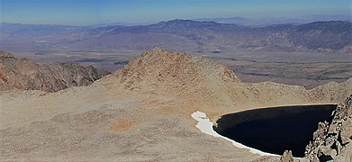
 Tulainyo Lake viewed from Mount Russell while Tunnabora Peak (left) and The Cleaver (right) frame the Owens Valley and Inyo Mountains | |
 Tulainyo Lake Tulainyo Lake's location in the Eastern Sierra | |
| Location | Sierra Nevada, California |
| Coordinates | 36°35′51″N 118°16′48″W |
| Type | Alpine lake |
| Etymology | Portmanteau of the names Tulare and Inyo |
| Primary inflows | Snowmelt |
| Primary outflows | None |
| Basin countries | United States |
| Max. length | 0.5 mi (0.80 km) |
| Max. width | 0.35 mi (0.56 km) |
| Surface area | 84.73 acres (34.29 ha) |
| Max. depth | Unknown |
| Shore length1 | 1.37 mi (2.20 km) |
| Surface elevation | 12,829 ft (3,910 m) |
| Frozen | Regularly in winter |
| Islands | None |
| References | [1] |
| 1 Shore length is not a well-defined measure. | |
Tulainyo Lake's total volume and depth are not known. Historical news sources report that "the lake lies in a great glacier-gouged bowl of nearly 400 feet (100 m) depth," but no reliable modern measurements have been conducted.[3] The lake's altitude and location at the very crest of the range mean that it is frozen over during the winter, such that it has even been ice skated, and ice and snow often linger around the lake's shoreline well into the summer.[4]
For many years after its initial mapping, Tulainyo Lake was considered the highest lake in the United States, or even North America.[5][6][3] Depending on the definition used, however, multiple "lakes" have been found at higher elevations. Several unnamed tarns in the Sierra Nevada are higher, as are a handful of named bodies of water, including Pacific Tarn in Colorado's Rocky Mountains and Lake Waiau on Mauna Kea in Hawaii.[7][8] The twin volcanic crater lakes of Nevado de Toluca in Mexico are at approximately 13,800 feet (4,200 m). However, Tulainyo Lake surpasses all of them in size, and may still be the highest named lake in California and the Sierra Nevada.[8]
In large part because of its high elevation, the lake played a notable role in the history of California's Eastern Sierra, and the California water wars, between Owens Valley residents and the city of Los Angeles. In 1937, the lake starred in the so-called Wedding of the Waters celebration honoring the opening of California State Route 190 from Owens Valley to Death Valley.
Geography
Tulainyo Lake is described as lying in a cirque that "doubtless held a small glacier until very recently." The lake is enclosed by a moraine, through which some water seeps out.[7] The lake is also rimmed with talus and surrounded by multiple high peaks: 13,563 ft (4,134 m) Tunnabora Peak to the north; 13,553 ft (4,131 m) Mount Carillon to the south; a 13,383 ft (4,079 m) subpeak of Carillon, named The Cleaver, to the east; and 14,094 ft (4,296 m) fourteener Mount Russell (the seventh-highest peak in the state) to the southwest.[2]
West of the lake, the terrain slopes down to the headwaters of Wallace Creek, which drains out of the Wallace Lakes basin before joining Wright Creek and eventually the upper Kern River.[2] Tulainyo Lake is not accessible by road or trail, and is most easily reached from the Wallace Lakes basin off of the John Muir Trail and Pacific Crest Trail 5 mi (8 km) to the west, or from the steep North Fork Lone Pine Creek drainage to the south, via the pass between Mount Russell and Mount Carillon.[9] A use trail extends from the John Muir Trail to Wallace Lake.[9]
History
Mapping and naming
The lake is partially visible from the summit of Mount Whitney, where the first recorded ascent took place in 1873.[10] The lake's surrounding summits, with views dominated by Tulainyo, were climbed in the early 20th century (Tunnabora Peak was first climbed in 1905, Carillon in 1925, and Mount Russell in 1926). According to the U.S. Board on Geographic Names, the name Tulainyo Lake was first given in 1917 by USGS chief geographer R.B. Marshall—it is a portmanteau, based on the lake's location in Tulare County, immediately west of the Inyo County line. The Board approved the name in 1928.[2][11] However, the name appears on maps as early as 1907, and a 1935 Oakland Tribune article states that it was believed the lake was named by government topographer G. R. Davis in 1905.[12][6]
20th century
Highest North American lake determination
On October 16, 1935, Chester Versteeg, chairman of the geographic committee of the Sierra Club, publicly announced that after two years of research, Tulainyo Lake had been ascertained the "highest lake on the American continent."[5] The lake's status was verified at the time by the United States Geological Survey.[5] Water from Tulainyo Lake was tested and found to be very soft (low in mineral content). At the time, Versteeg mused about building a trail connecting Tulainyo Lake to the John Muir Trail, but ultimately no such trail was constructed.[5] Versteeg's announcement received coverage in newspapers throughout the American West, including the Los Angeles Times, the Oakland Tribune, the Deseret News, and the Reno Gazette-Journal. The Tribune even speculated that, as the lake was higher than Bolivia and Peru's Lake Titicaca (generally recognized as the world's highest lake at that time), Tulainyo Lake might even be the highest lake in the world.[6]
Wedding of the Waters
In 1937, Tulainyo Lake played a major role in the opening and dedication of California State Route 190 from the town of Olancha to Death Valley, which officially linked the highest—Mount Whitney, via Whitney Portal—and lowest points in the contiguous United States.[13][14] The elaborate ceremony—devised and organized by local boosters such as Fr. John J. Crowley—was called the Wedding of the Waters.[13][15] It involved taking water from the country's highest lake (as Tulainyo was known then) to its lowest (the endorheic Badwater Basin sometimes contains an ephemeral saltwater lake) via a wide variety of transportation methods.[16]
To commence the ceremony, on October 29, 1937, a young Washoe Native American youth from Nevada named Jerry Emm cracked the ice on Tulainyo Lake and filled a gourd with water.[14][15] He ran 17 miles (27 km) with the gourd, down to Whitney Portal at 8,374 ft (2,552 m), where a series of horseback riders recalling the heavily mythologized Pony Express brought it to the town of Lone Pine in Owens Valley, at the foot of the Sierra Nevada.[14][13][15] That night, the water remained in a bank vault while some was served to Governor of California Frank Merriam at a celebratory dinner.[15] The next day, the gourd of water was conveyed by a miner on donkey down Main Street, handed off to a covered wagon, again passed off to a twenty-mule team, and then to a stagecoach.[15][17] Next, a narrow-gauge railway train took the gourd to Keeler.[15] October 31 marked the gourd's final travel segments, from Keeler to the new highway's cutoff to Darwin, in a 1938 Lincoln-Zephyr car, where the highway was officially opened.[13][15] The ceremony featured descendants of the Donner Party and Death Valley '49ers, as well as Governor Merriam, and President Franklin D. Roosevelt via telex.[17][13]
The gourd was put on board a plane in Panamint Valley, and finally the water from Tulainyo Lake was dropped by T.R. Goodwin, first superintendent of Death Valley National Monument, into the ephemeral lake of Badwater Basin: the lowest point in North America.[15][17] Signal fires were lit across the mountains from Dante's View to the summit of Mount Whitney, where a firefall lit by Norman Clyde culminated the ceremony.[17][15] The sequence of transportation methods for the gourd was intended to recreate their use in California's history, from earliest and most 'primitive' to most recent.[18][15]
Stocking of trout
In the 1930s, the lake was stocked with golden trout by the California State Fish and Game Commission.[19] The mountainous terrain was deemed too risky for aerial fish stocking, where fish are released from low-flying aircraft. So, in 1938, 10,000 juvenile trout from the Mount Whitney Fish Hatchery had to be transported by mule, 40 miles (64 km) and 9,000 feet (2,700 m) in elevation from the hatchery, over Shepherd Pass into the Kern River basin, where they were taken cross-country through the Wallace Lakes basin to Tulainyo Lake.[20] Kept in specially designed aerated cans slung over the backs of the mules, the trout were released into walled-in sections of streams as workers camped for the night. A mere 20 trout died on the journey, but there were concerns about whether any of the remaining trout would survive the bitter winter at nearly 13,000 feet (4,000 m).[20] They reportedly thrived for several years, but their fate beyond that is unknown.[21] Other fish stocking efforts in Tulainyo Lake are referenced in 1933, and in 1936, but in less detail.[22][23][24]
Aviation events
In winter of 1950, Johnny Hodgkin, a rancher and pilot from Selma, California, landed a light plane on skis adjacent to Tulainyo Lake, potentially setting a then-record for highest-altitude aircraft landing and takeoff. As Tulainyo Lake and its environs were within the boundaries of Sequoia National Park, he was reprimanded by park authorities and forbidden from repeating the stunt.[25]
The lake's vicinity was also the site of an aviation accident in the 1960s. On February 8, 1969, Hawthorne Nevada Airlines 'Gambler's Special' Flight 708 (a Douglas DC-3 airliner flying from Hawthorne, Nevada to Burbank, California) crashed into the sheer cliffs forming Tulainyo Lake's eastern ramparts, high above the Hogback Creek drainage.[26] All 35 passengers were killed. The crash occurred in poor weather and at night during a new moon; investigators concluded the proximate cause was deviation from the assigned flight path, as the crew likely thought they were further south, near Palmdale. Due to the inclement weather, including heavy snowfall, the wreckage site was not discovered until 6 months later on August 8. On August 10, an Air Force HH-43B Huskie helicopter carrying investigators to the accident site itself crashed just 100 yards (meters) away, causing one serious injury.[26]
Guyford Stever muon research
In 1939, American physicist Guyford Stever used Tulainyo Lake as a location for his research on cosmic rays while in graduate school at the California Institute of Technology (CalTech).[27] Stever and two fellow graduate students were using recording electroscopes with a quartz fiber, and a battery-powered clock to recharge the fiber, to measure the intensity of mesons at two different altitudes. To eliminate absorption effects, and to ensure that any detected difference in the quantity of mesons was due to their decay while in transit (mesons are extremely short-lived), Stever and his fellows immersed the electroscopes deep in water. Their higher-elevation experiment site was Tulainyo Lake, where the men carried equipment by mule and paddled out in a faltboot in early September and attached the electroscope to a buoy, where it remained for several days. The experiment was successful, although the faltboot was damaged and some equipment lost during a storm when the boat overturned. Afterwards, the experiment attracted the attention of American physicist J. Robert Oppenheimer.[27][28]
Other events
Tulainyo Lake was reportedly the favorite lake of Norman Clyde, a prolific and notable mountaineer and guide in the early 20th-century Sierra Nevada.[29][30]
Tulainyo Lake was briefly the record-holder for the site of the highest-elevation scuba dive in the United States, performed by Peter Hemming and David Moore in 1998. The pair dove to a depth of approximately 30 feet (9 m) for 15 minutes.[31]
Climate and ecology
According to the Köppen climate classification system, Tulainyo Lake is located in an alpine climate zone.[32] Most weather fronts in the region originate in the Pacific Ocean and travel east toward the Sierra Nevada; as the fronts approach the peaks, they are forced upwards (in a classic case of orographic lift), inducing them to drop their moisture as rain or snowfall.[33] Precipitation runoff has no major outlet from Tulainyo Lake, and leaves primarily through evaporation or seepage.[7]
Tulainyo Lake is well above tree line and subject to cold and snowy conditions for much of the year, having an alpine ecology.[34] No trees and very few plants grow in the vicinity of Tulainyo: one example is Polemonium eximium, or sky pilot, a cushion plant that grows low to the ground.[35] Most animals are transient, such as the butterfly Parnassius phoebus and the gray-crowned rosy finch, the few exceptions include yellow-bellied marmots and the American pika, which live in burrows constructed among rocks.[35] Early 20th-century sources indicate the lake itself was stocked with golden trout in the 1930s, and Hemming and Moore reported sighting a small fish in the lake during their record-breaking scuba dive in 1998.[22][31][24][23]
Gallery of surrounding topography
 1 2 3 4 5 6 7 | |||||||||||||||||||
Tulainyo Lake's location along the crest of the Sierra Nevada (faint line marked in gray)
| |||||||||||||||||||
 Tunnabora Peak, viewed from Mount Russell above Tulainyo Lake
 Mount Carillon (right) and its subpeak The Cleaver (left)
 Mount Russell, viewed from Mount Whitney


See also
- Altitude diving
References
- "Lake Attribute Data". Archived from the original on April 26, 2022. Retrieved August 26, 2022.
- "Tulainyo Lake Feature Details". USGS Geographic Names Information System. Archived from the original on August 23, 2022. Retrieved August 23, 2022.
- "Tulare County Lake Nearly 13,000 Feet In Elevation Is Highest In Entire Nation". Tulare Advance-Register. October 22, 1935. p. 5. Archived from the original on August 25, 2022. Retrieved August 29, 2022.
- Sherman, Leonie (December 3, 2013). "Wild Ice". Adventure Sports Journal. Archived from the original on August 23, 2022. Retrieved August 25, 2022.
- "Highest Lake in America Discovered in California". Los Angeles Times. October 17, 1935. p. 23. Archived from the original on August 25, 2022. Retrieved August 25, 2022.
- "Highest Lake in America Found on Tulare-Inyo County Border". Oakland Tribune. October 18, 1935. Archived from the original on August 25, 2022. Retrieved August 25, 2022.
- "Geological Survey Professional Paper 504—A: Glacial Reconnaissance of Sequoia National Park California". National Park Service. Archived from the original on August 23, 2022. Retrieved August 23, 2022.
- "The Highest Lake in the USA". highestlake.com. Archived from the original on May 15, 2021. Retrieved August 23, 2022.
- "Mount Russell North Ridge". SummitPost.org. Archived from the original on August 23, 2022. Retrieved September 6, 2022.
- "Mt. Whitney History". Lone Pine Chamber of Commerce. Archived from the original on August 27, 2022. Retrieved August 27, 2022.
- Farquhar, Francis P. (1926). "Place Names of the High Sierra (1926), "T"". www.yosemite.ca.us. Archived from the original on March 31, 2022. Retrieved August 23, 2022.
- U.S. Geological Survey, USGS (1907). "Mt. Whitney, Calif". David Rumsey Map Collection. Archived from the original on August 25, 2022. Retrieved August 25, 2022.
- "Densho Digital Archive - Kerry Christenson Powell Interview". Densho Digital Archive. September 16, 2013. Archived from the original on August 23, 2022. Retrieved August 25, 2022.
- Whitney, Paul (October 30, 1937). "Road Opening Fete Begins". Los Angeles Times. p. 5. Archived from the original on August 25, 2022. Retrieved August 25, 2022.
- Crowley, Fr. John J. "The Wedding of the Waters" (PDF). Owens Valley History. Archived (PDF) from the original on January 8, 2022. Retrieved August 25, 2022.
- "Highway Fete Plans Pushed". Los Angeles Times. October 17, 1937. p. 12. Archived from the original on August 25, 2022. Retrieved August 25, 2022.
- "Valley Family Take Part In Road Dedication Program". Santa Ynez Valley News. November 5, 1937. p. 1. Archived from the original on August 25, 2022. Retrieved August 25, 2022.
- "Wedding of the Waters – California's Gold (110)". Huell Howser Archives at Chapman University. August 12, 1999. Archived from the original on August 23, 2022. Retrieved August 25, 2022.
- "Golden Trout Planted in U.S. Highest Lake". The Fresno Bee. January 8, 1939. p. 18. Archived from the original on August 25, 2022. Retrieved August 25, 2022.
- "Golden Trout March Across Sierran Pass to Stock Highest Lake". Los Angeles Times. January 1, 1939. p. 3. Archived from the original on August 25, 2022. Retrieved August 25, 2022.
- Clyde, Norman (June 5, 1952). "Wild Life Near Mt. Whitney". Indian Valley Record. p. 6. Archived from the original on August 25, 2022. Retrieved August 25, 2022.
- Salisbury, Ceph B. (June 30, 1933). "Golden Trout Season to Open Tomorrow; Fishing Better in Lakes, Ocean". San Pedro News Pilot. Vol. 6. p. 22. Archived from the original on August 23, 2022. Retrieved August 23, 2022.
- "Home of World's Highest Fish". Napa Journal. February 18, 1937. p. 2. Archived from the original on August 25, 2022. Retrieved August 25, 2022.
- "California". Wisconsin Conservation Bulletin. Vol. 1, no. 8–12. 1936. p. 26. Archived from the original on September 28, 2022. Retrieved August 25, 2022.
- "Selma Skier Uses Airplane To Reach Choice Slopes In High Sierra Mountains". The Fresno Bee. March 19, 1950. p. 36. Archived from the original on August 25, 2022. Retrieved August 25, 2022.
- Shuit, Doug (August 11, 1969). "Copter Crashes Near Wreck of Gamblers Plane". Los Angeles Times. p. 1. Archived from the original on August 25, 2022. Retrieved August 25, 2022.
- Stever, Horton Guyford (2002). In War and Peace: My Life in Science and Technology. National Academies Press. pp. 12–19. ISBN 9780309169523.
- Kelly, Cynthia C. (2006). Oppenheimer and the Manhattan Project: Insights into J. Robert Oppenheimer, "Father of the Atomic Bomb". Hackensack, New Jersey: World Scientific. ISBN 978-981-256-418-4. OCLC 65637244.
- Robinson, Kim Stanley (May 10, 2022). The High Sierra: a love story (1st ed.). New York: Little, Brown and Company. ISBN 978-0-316-30681-2. OCLC 1315758405.
- Arnold, Daniel (September 9, 2009). Early Days in the Range of Light: Encounters with Legendary Mountaineers. Berkeley, CA: Counterpoint Press. ISBN 978-1-58243-655-5. OCLC 716255138.
- Hemming, Peter (April 29, 1999). "Lake Tulainyo". Sport Diver. Archived from the original on October 27, 2017. Retrieved August 23, 2022.
- "Climate of the Sierra Nevada". Encyclopædia Britannica. Archived from the original on July 11, 2022. Retrieved August 26, 2022.
- Dettinger, Michael; Redmond, Kelly; Cayan, Daniel (December 1, 2004). "Winter Orographic Precipitation Ratios in the Sierra Nevada—Large-Scale Atmospheric Circulations and Hydrologic Consequences". Journal of Hydrometeorology. 5 (6): 1102–1116. Bibcode:2004JHyMe...5.1102D. doi:10.1175/JHM-390.1. ISSN 1525-7541. Archived from the original on January 28, 2022. Retrieved September 6, 2022.
- Joyce, Quinn, ed. (2015). Earth's Landscape: An Encyclopedia of the World's Geographic Features [2 volumes]. ABC-CLIO. pp. 511–512. ISBN 978-1610694469. Archived from the original on August 29, 2022. Retrieved May 8, 2016.
- Schoenherr, Allan A. (1995). A Natural History of California. University of California Press. ISBN 0-520-06922-6.
Sequoia National Park | |
|---|---|
| Landmarks and attractions |
|
| People |
|
| Nearby municipalities | |
| Additional information |
|
| |
| Mountains |
| |||||||||||
|---|---|---|---|---|---|---|---|---|---|---|---|---|
| Passes |
| |||||||||||
| Rivers | ||||||||||||
| Lakes | ||||||||||||
| Protected areas |
| |||||||||||
| Communities | ||||||||||||
| Ski areas |
| |||||||||||
| Trails |
| |||||||||||

State of California | |
|---|---|
Sacramento (capital) | |
| Topics |
|
| Regions |
|
| Metro regions |
|
| Counties |
|
| Most populous cities | |
Другой контент может иметь иную лицензию. Перед использованием материалов сайта WikiSort.org внимательно изучите правила лицензирования конкретных элементов наполнения сайта.
WikiSort.org - проект по пересортировке и дополнению контента Википедии