geo.wikisort.org - Reservoir
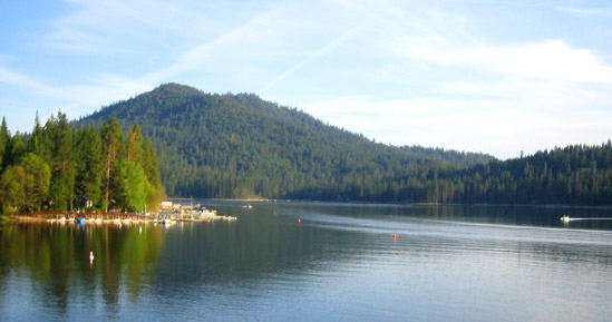
Bass Lake is located in the Sierra National Forest, of Madera County, California, approximately 14 mi (23 km) south of the entrance to Yosemite National Park. The lake is approximately four miles long and one-half mile wide.
| Bass Lake | |
|---|---|
 | |
 Bass Lake  Bass Lake | |
| Location | Sierra National Forest Madera County, California |
| Coordinates | 37.29077°N 119.52513°W |
| Type | Reservoir |
| Primary inflows | Willow Creek Browns Creek Ditch |
| Primary outflows | Willow Creek |
| Basin countries | United States |
| Max. length | 6.7 km (4.2 mi) |
| Max. width | 0.64 km (0.40 mi) |
| Surface area | 472 ha (1,170 acres) |
| Max. depth | 30 m (98 ft) |
| Water volume | 56,100 dam3 (45,500 acre⋅ft) |
| Surface elevation | 1,027 m (3,369 ft) |
| Settlements | Bass Lake, California |
| Website | https://www.basslake.com/ |
| References | [1][2] |
The lake is formed by the construction of the Crane Valley Dam across Willow Creek, a tributary to the San Joaquin River, and is referenced as Crane Valley Lake.[3] Releases from the dam drive the hydro-electric powerplant operated by Pacific Gas and Electric Company.[4] The 145 ft (44 m) concrete gravity dam was completed in 1910 by Pacific Gas and Electric.[5]
Most of the land around the lake is part of the Sierra National Forest. The U.S. Forest Service designated the lake an official Recreation Area and has developed campgrounds and picnic areas on the south shore of the lake. The north shore of the lake is primarily made up of private cabins and homes of the unincorporated community, Bass Lake, California, with a year-round population of 575.[6]
Geography
Bass Lake is located on the western slope of the Sierra Nevada at an elevation of 3,370 feet (1,030 m).[7]
Bass Lake reservoir was created by the Crane Valley Dam, which impounds North Fork Willow Creek. It’s also fed by South Fork Willow Creek through the Brown’s Ditch diversion, as well as Slide, Pines, and Salter Creeks. Willow Creek is the lake’s only outlet which flows south through the community of North Fork before its confluence with the San Joaquin River.
The lake is bound by Malum Ridge on the south and by Graham Mountain[8] which rises dramatically to an elevation of 6,090 feet (1,860 m) in the northeast. Goat Mountain,[9] which frames the lake on the west, is named after the goats that helped compact the soil of the original earthwork dam who grazed there.[10]
Climate
Bass Lake has a Mediterranean climate (Koppen CSA) climate with hot, dry summers and cool, rainy winters with occasional heavy snowstorms. Its hardiness zone is 8b.[11]
Mono Winds
Mono Winds are a localized weather phenomenon of strong foehn winds caused when high-pressure systems in the Great Basin push air up and over the Sierra. The rugged topography funnels the air, intensifying wind speeds to 50 mph with gusts over 80 mph in narrow areas of effect.[12]
Mono Winds occur from October to April but are most common in December and January.[13] Episodes average about one or two a year; some years they do not occur at all. Strong winds can last just a few hours but can be quite destructive. In January 2021, Mono Winds caused significant damage to homes and powerlines in the Bass Lake area, blocking roads and creating a prolonged power outage.[14]
Human History
Native People
Bass Lake was home to the Mono Native Americans who were the area's only human inhabitants until the time of the California Gold Rush. Many Mono were forcibly removed from Crane Valley in May 1851 during the Mariposa War that served to open the Southern Sierra Nevada to white settlers under the Act for the Government and Protection of Indians.[15] Mono continued to live traditionally in the surrounding area until the creation of the Sierra National Forest in 1897 when permits became a requirement for the use of federal lands. Only citizens could get permits, and the rights of citizenship were not granted to Native Americans until the Indian Citizenship Act of 1924.[16]
Development
Lumber Industry
In 1854, Charles P. Converse and Bill Chitiser built the first lumber mill at the base of Willow Creek falls. Their operation began the clearing of the Crane Valley basin, opening it up to ranching and farming, and ultimately, Bass Lake reservoir.
The logging industry boomed with the arrival of steam power. By the 1920s, the town of Wishon on the western shore of Bass Lake was the switching place for the Sugar Pine Lumber Company, the last logging company to be built in the Southern Sierra. Railroad tracks connected Bass Lake with the logging headquarters of Central Camp, which was serviced by the largest saddle-tank locomotive ever built to haul log cars up the twelve-mile, 4.5 percent grade. The railroad was never profitable, and in its final two years, operated as a heritage railway, running tourist excursions from Pinedale before shutting down in 1931.[17]
Hydroelectricity
The lake was formed with the construction of Crane Valley reservoir by the San Joaquin Electric Company in 1901 to generate hydroelectric power for the residents of the San Joaquin Valley.
The dam has been enlarged several times. First in 1905, then in 1910 to a height of 145 feet. In 2012, an extensive seismic retrofit project was completed that buttressed the structure with 300,000 cubic yards of rock and raised the crest of the dam another 8 feet.[18]
The lake fills to capacity during years of normal precipitation and seasonal snowpack with water released gradually over the summer and fall months to satisfy demand for irrigation and hydroelectric power. By December, the lake levels can be drawn down to 35% of total capacity, or 36 feet below crest elevation, in anticipation of seasonal weather and runoff.[19] Bass Lake is not a multi-year water storage reservoir.[20]
In November 2020, PG&E announced plans to sell the Crane Valley Hydroelectric Project, which includes the Bass Lake reservoir and surrounding PG&E owned property.[21]
Recreational Use
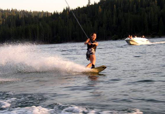
Much of the area surrounding Bass Lake is devoted to the tourism industry and is home to several small resorts and two summer camps. The lake water typically reaches 80 °F (27 °C) during the summer months. Fishing, swimming, water skiing, and personal watercrafting are popular.[22] Bass Lake is also a popular staging location for high Sierra excursions or day trips to nearby Yosemite National Park.
Hells Angels
In 1963, Bass Lake became a yearly destination for the Hells Angels Motorcycle Club (HAMC), attracting hundreds of bikers from across the state. A first-hand report of the 1965 Bass Lake Run was reported by Hunter S. Thompson in his first book, Hell's Angels: The Strange and Terrible Saga of the Outlaw Motorcycle Gangs.[23]
Most locals viewed the run as an annual menace that brought crime and frightened tourists away. Each year roadblocks, curfews, and campground restrictions were enforced by law enforcement from throughout Madera County and its surrounding areas in an effort to block, or at least control, the Hells Angels activity.
The run peaked in the 1970s before slowly fading away altogether by the late 1980s.
See also
- List of lakes in California
References
- "Bass Lake Dam". BassLakeCA.com. 2009. Retrieved 2009-03-13.
- U.S. Geological Survey (2009). "Feature Detail Report: Bass Lake". Geographic Names Information System (GNIS). U.S. Department of the Interior. Retrieved 2009-03-13.
- Department of Water Resources Division of Safety of Dams (2009). "Listing of Dams". California Data Exchange Center. State of California. Retrieved 2009-04-01.
- "Bass Lake History". BassLakeCA.com. 2009. Retrieved 2009-03-13.
- "Bass Lake". Archived from the original on 2010-11-23.
- "Population and Housing Unit Estimates". United States Census Bureau. Retrieved January 17, 2022.
- "U.S. Geological Survey Geographic Names Information System: Bass Lake, California". United States Geological Survey. January 18, 1981. Retrieved November 22, 2021.
- "U.S. Geological Survey Geographic Names Information System: Graham Mountain, California". United States Geological Survey. December 31, 1981. Retrieved November 22, 2021.
- "U.S. Geological Survey Geographic Names Information System: Goat Mountain, California". United States Geological Survey. December 31, 1981. Retrieved November 22, 2021.
- Freeman, Marcia Penner (2013). Willow Creek History: Tales of Cow Camps, Shake Makers & Basket Weavers. The History Press. p. 108. ISBN 978-1-60949-644-9.
- "California Hardiness Zone Map - Bass Lake, California". PlantMaps. December 31, 1981. Retrieved November 22, 2021.
- Ruscha, Charles P. Jr. (February 1976). "Forecasting the Mono Wind" (PDF). National Oceanic and Atmospheric Administration. NWS WR-105. Retrieved November 22, 2021.
- "Roadside Naturalist: Effects of the Mono Winds". U.S. National Park Service - High Country Notebook. September 8, 2012. Retrieved November 22, 2021.
- Rodriguez, Rich (January 19, 2021). "Falling trees cause extensive damage at Bass Lake". KMPH-TV. Fresno, California. Retrieved November 22, 2021.
- Freeman, Marcia Penner (2013). Willow Creek History: Tales of Cow Camps, Shake Makers & Basket Weavers. The History Press. pp. 23–29. ISBN 978-1-60949-644-9.
- Barnes, Dwight H. (2001). Miners, Lumberjacks and Cowboys: A History of Eastern Madera County. Sierra Historic Sites Association. p. 13. ISBN 0-9707605-0-7.
- Johnston, Hank (1997). The Whistles Blow No More. Railroad Logging in the Sierra Nevada 1874-1942. Stauffer Publishing. p. 63. ISBN 0-87046-067-6.
- Ritzman, David; Makdisi, Faiz; de Larios, Joseph; Sun, Joseph; Ahlgren, Charles (May 2, 2013). "Seismic Retrofit of Crane Valley Dam". Missouri University of Science and Technology. Retrieved November 22, 2021.
- Ritzman, David; Makdisi, Faiz; de Larios, Joseph; Sun, Joseph; Ahlgren, Charles (May 2, 2013). "Seismic Retrofit of Crane Valley Dam". Missouri University of Science and Technology. Retrieved November 22, 2021.
- "Residents prepare to evacuate after PG&E warns Bass Lake may spill over". KFSN-TV. Fresno, California. February 15, 2019. Retrieved November 22, 2021.
- Rodriguez, Rich (November 9, 2020). "Bass Lake included in the sale of PG&E's Crane Valley Hydroelectric Project". KMPH-TV. Fresno, California. Retrieved November 22, 2021.
- "Bass Lake (Crane Valley)". Madera County, California GenWeb. 21 December 2008. Retrieved 2009-03-13.
- Thompson, Hunter S. (1966). Hell's Angels: A Strange and Terrible Saga. Ballantine Books. ISBN 0-345-41008-4.
External links
- Bass Lake weather and lake conditions
- Madera County official website
- Oakhurst Area Chamber of Commerce
- http://www.basslakechamber.com/history.html
| Mountains |
| |||||||||||
|---|---|---|---|---|---|---|---|---|---|---|---|---|
| Passes |
| |||||||||||
| Rivers | ||||||||||||
| Lakes | ||||||||||||
| Protected areas |
| |||||||||||
| Communities | ||||||||||||
| Ski areas |
| |||||||||||
| Trails |
| |||||||||||

Другой контент может иметь иную лицензию. Перед использованием материалов сайта WikiSort.org внимательно изучите правила лицензирования конкретных элементов наполнения сайта.
WikiSort.org - проект по пересортировке и дополнению контента Википедии