geo.wikisort.org - River
The Kern River, previously Rio de San Felipe, later La Porciuncula, is an Endangered, Wild and Scenic river in the U.S. state of California, approximately 165 miles (270 km) long. It drains an area of the southern Sierra Nevada mountains northeast of Bakersfield. Fed by snowmelt near Mount Whitney, the river passes through scenic canyons in the mountains and is a popular destination for whitewater rafting and kayaking. It is the southernmost major river system in the Sierra Nevada, and is the only major river in the Sierra that drains in a southerly direction.
| Kern River Rio de San Felipe, La Porciuncula, Po-sun-co-la, Porsiuncula River[1] | |
|---|---|
 Panorama of the upper Kern River | |
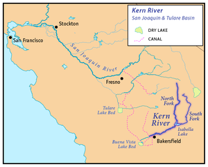 Map of the San Joaquin and Tulare Basin region with the Kern River highlighted. Some rivers shown are intermittent or normally dry. A few selected canals are shown. Below: Map of the San Joaquin and Tulare Basin region showing the old lakes and river courses. | |
| Location | |
| Country | United States |
| State | California |
| Region | Sierra Nevada, San Joaquin Valley |
| District | Tulare County, Kern County |
| City | Bakersfield |
| Physical characteristics | |
| Source | Kings-Kern Divide |
| • location | Sequoia National Park |
| • coordinates | 36°41′48″N 118°23′53″W[2] |
| • elevation | 13,608 ft (4,148 m)[3] |
| Mouth | Buena Vista Lake Bed |
• location | San Joaquin Valley |
• coordinates | 35°16′4″N 119°18′25″W[2] |
• elevation | 299 ft (91 m)[2] |
| Length | 164 mi (264 km)[2] |
| Basin size | 3,612 sq mi (9,360 km2)[4] |
| Discharge | |
| • location | Near Democrat Springs, CA[5] |
| • average | 946 cu ft/s (26.8 m3/s)[5] |
| • minimum | 10 cu ft/s (0.28 m3/s) |
| • maximum | 47,000 cu ft/s (1,300 m3/s) |
National Wild and Scenic River | |
| Type | Wild, Scenic, Recreational |
| Designated | November 24, 1987 |
The Kern River formerly emptied into the now dry Buena Vista Lake and Kern Lake via the Kern River Slough, and Kern Lake in turn emptied into Buena Vista Lake via the Connecting Slough at the southern end of the Central Valley. Buena Vista Lake, when overflowing, first backed up into Kern Lake and then upon rising higher drained into Tulare Lake via Buena Vista Slough and a changing series of sloughs of the Kern River. The lakes were part of a partially endorheic basin that sometimes overflowed into the San Joaquin River.[6] This basin also included the Kaweah and Tule Rivers, as well as southern distributaries of the Kings River that all flowed into Tulare Lake.
Since the late 19th century the Kern has been almost entirely diverted for irrigation, recharging aquifers, and the California Aqueduct, although some water empties into Lake Webb and Lake Evans, two small lakes in a portion of the former Buena Vista Lakebed. The lakes were created in 1973 for recreational use. The lakes hold 6,800 acre⋅ft (8,400 dam3) combined.[7] Crops are grown in the rest of the former lakebed. In extremely wet years the river will reach the Tulare Lake basin through a series of sloughs and flood channels.
Despite its remote source, nearly all of the river is publicly accessible. The Kern River is particularly popular for wilderness hiking and whitewater rafting. The Upper Kern River is paralleled by trails to within a half-mile of its source (which lies at 13,600 feet (4,100 m)). Even with the presence of Lake Isabella, the river is perennial down to the lower Tulare Basin. Its swift flow at low elevation makes the river below the reservoir an extremely popular location for rafting.
Course
The Kern begins in the Sierra Nevada in Sequoia National Park in northeastern Tulare County, near the border with Inyo County.[8] The main branch of the river (sometimes called the North Fork Kern River) rises from several small lakes in a basin northwest of Mount Whitney. The headwaters are surrounded by the Great Western Divide to the west, the Kings-Kern Divide to the north and the main Sierra Crest to the east, all of which have multiple peaks above 13,000 feet (4,000 m).[8] The Kern River flows due south through a deep glacier-carved valley, passing through Inyo and Sequoia National Forests and the Golden Trout Wilderness, and receiving numerous tributaries including Rock Creek, Big Arroyo, Golden Trout Creek and Rattlesnake Creek.[9][10][11] After deviating briefly from its due south course as it flows east around Hockett Peak, it is joined by the Little Kern River from the northwest at a site called Forks of the Kern.[12] Below there, the Kern River continues south, and is joined by more tributaries including Peppermint Creek, South Creek, Brush Creek, and Salmon Creek, which all form large waterfalls as they tumble into the Kern River canyon.[13][14][15]
At Kernville the river emerges from its narrow canyon into a wide valley where it is impounded in Lake Isabella, formed by Isabella Dam.[16] The area was once known as Whiskey Flat, the former location of the town of Kernville. In Lake Isabella, it is joined by its largest tributary, the South Fork Kern River, which drains a high plateau area to the east of the North Fork drainage.[17] The 95-mile (153 km)-long South Fork rises in Tulare County and flows south through Inyo National Forest, turning west after entering Kern County.[18][19]
Below Isabella Dam the Kern River flows southwest in a rugged canyon along the south edge of the Greenhorn Mountains, parallel to SR 178. A number of hot springs are located along this section of the river.[20][21] With a descent of 2,000 feet (610 m) between Isabella Dam and Bakersfield, this section of the Kern River feeds several hydroelectric plants and is also a popular whitewater run. Due to upstream dam releases for irrigation and power generation, this part of the river has a swift flow even in the driest summers.[22] The river then flows through a winding valley in the Sierra foothills[23] before entering the San Joaquin Valley at Bakersfield, the largest city on the river.[24] In Bakersfield proper, most of the river's flow is diverted into various canals for agricultural use in the southern San Joaquin Valley, and provide municipal water supplies to the City of Bakersfield and surrounding areas. Diverting the river's flow has left 10 miles of the riverbed that runs through Bakersfield dry. This fertile region is a large alluvial plain, or inland delta, formed by the Kern River, which once spread out into vast wetlands and seasonal lakes.
The Friant-Kern Canal, constructed as part of the Central Valley Project, joins the Kern about 4 mi (6.4 km) west of downtown Bakersfield, restoring some flow to the river. The river channel continues about 20 miles (32 km) southwest to a point near the California Aqueduct on the western side of the San Joaquin Valley. A weir allows excess floodwaters from the Kern to drain into the California Aqueduct, while any remaining water continues south into the seasonal Buena Vista Lake, which once reached sizes of about 4,000 acres (1,600 ha) in wet periods. Historically, a 20 mi (32 km) distributary of the Kern split off above Bakersfield and flowed south to what is now Arvin, where it formed the seasonal Kern Lake, which would grow to cover about 8,300 acres (3,400 ha) during wet periods. Water from Kern Lake would then flow west through Buena Vista Slough into Buena Vista Lake.
In periods of extremely high runoff, Buena Vista Lake overflowed and joined other wetlands and seasonal lakes in a series of sloughs that drained north into the former Tulare Lake, which would sometimes overflow into the San Joaquin River via Fresno Slough.[25]
The Kern River is one of the very few rivers in the Central Valley which does not contribute water to the Central Valley Project (CVP). However, water from the CVP, mainly the Friant-Kern Canal, will be deposited for water storage in the aquifers.
History

The river was named by John C. Frémont in honor of Edward M. Kern in 1845 who, as the story goes, nearly drowned in the turbulent waters.[citation needed] Kern was the topographer of Fremont's third expedition through the American West. Before this, the Kern River was known as the "Rio de San Felipe" as named by Spanish missionary explorer Fr. Francisco Garcés when he explored the Bakersfield area on May 1, 1776. On August 2, 1806, Padre Zavidea renamed the river La Porciuncula for the day of the Porciuncula Indulgence. It was locally known as Po-sun-co-la until its renaming by Fremont.[1]
Gold was discovered along the upper river in 1853. The snowmelt that fed the river resulted in periodic torrential flooding in Bakersfield until the construction of the Isabella Dam in the 1950s. These floods would periodically change the channel of the river. Since the establishment of Kern County in 1866 the main channel has flowed through what is the main part of downtown Bakersfield along Truxtun Avenue and again made a south turn along what is Old River Road. Many of the irrigation canals that flow in a southerly direction from the river follow the old channels of the Kern River, especially the canal that flows along Old River Road. The irrigated region of the Central Valley near the river supports the cultivation of alfalfa, carrots, fruit, and cotton, cattle grazing, and many other year-round crops. In 1987 the United States Congress designated 151 miles (243 km) of the Kern's North (Main) Fork and South Fork as a National Wild and Scenic River.
The Great 1857 Fort Tejon earthquake on January 9, 1857, with an estimated magnitude of 7.9 on the San Andreas Fault was strong enough to temporarily switch the direction of the flow of the Kern River. Fish in the now dry Tulare Lake were left stranded on the shores.[26]
The Buena Vista Lake basin is an arid area and the Kern River is the only significant water supply. Ongoing conflicts between urban and agricultural interests complicate management decisions, in recent years owing to the expiration of some long-term contractual agreements. [27] Exacerbating the problem, ongoing dam safety problems at Isabella Dam have led to reduced water storage there while repairs are made. [28]
Lux v. Haggin - 1886 Historic California Supreme Court Case on Water Rights in California
The Kern River was at the center of Lux v. Haggin, 69 Cal. 255; 10 P. 674; (1886), a historic case in the development of water rights in California, and also one of the most consequential water lawsuits in American history.
The overarching issue in Lux v. Haggin was whether the court would uphold English common law riparian rights (even though they were poorly suited to California's Mediterranean climate), institute the primacy of appropriative water rights, or create an entirely new system of water rights. The decision was important because it gave the court a chance to either continue to uphold English common law and riparian rights or give appropriative rights supremacy.
In the end, the court recognized both water rights systems but decided that appropriative rights were secondary to riparian rights. The ruling "created chaos by shackling the state with two fundamentally incompatible water allocation systems."
Additionally, the original definition of "reasonable" water use under English common law was changed. The court decided that water could be used for commercial and agricultural purposes as long as the use did not negatively affect other riparian landowners. This broadening of the "reasonable" use definition meant that riparian landowners could now use more water than previously allowed.
The subsequent 1888 Miller-Haggin Agreement that divides the water between First Point and Second Point users, still governs the use of Kern River water today.
National Wild And Scenic Rivers System Designation
On November 24, 1987, The North and South Fork of the Kern River were designated as Wild & Scenic under the Wild & Scenic Rivers Act. The Wild & Scenic designation covers 151.0 total miles broken down as follows. Wild — 123.1 miles; Scenic — 7.0 miles; Recreational — 20.9 miles. [29]
Endangered River Status

The Lower Kern River was listed by American Rivers as one of America’s most endangered rivers of 2022.[30] According to American Rivers, "decades of excessive water diversions for agriculture operations have dried up the last 25 miles of the Lower Kern River.[31]". Water right holders, use a series of canals, many that run right next to the dry riverbed, to divert water from the natural riverbed and in the process have allowed the Lower Kern River to run dry. Doing so has denied the 500,000 residents of the surrounding communities access to flowing river in direct violation of the public trust doctrine. "Under the Public Trust Doctrine, California is obligated to protect flowing waterways for the benefit of current and future generations."[32]
There are several local groups such as Bring Back the Kern, Kern River Fly Fishers, and The Kern River Parkway Foundation that are working to restore the Lower Kern River.[citation needed]
Ecology
The Kern River watershed is the native range of California's State Freshwater Fish, California golden trout (Oncorhynchus mykiss aguabonita), which are native to the Kern River tributaries South Fork Kern River and Golden Trout Creek,[33] and the latter's tributary, Volcano Creek.[34] Two currently recognized and closely related sibling subspecies. The Little Kern golden trout (O. m. whitei), found in the Little Kern River basin, and the Kern River rainbow trout (O. m. gilberti), are also found in the Kern River system. Together, these three trout form what is sometimes referred to as the "Golden Trout Complex".[35]
In 2008, after public outcry, the City of Bakersfield and the California Department of Fish and Game (CDFG) decided to relocate a family of California Golden beaver (Castor canadensis subauratus) instead of killing them.[36] California Golden beaver were native to the Central Valley and throughout the Sierra Nevada. Specifically to the Kern watershed, an oral history was taken from Roy De Voe, who claimed to have seen "very old beaver sign" on the east side of the Kern River at Funston Meadow (elevation 6,476 feet (1,974 m))[37] in 1946. Also, Mr. De Voe reported that his friend Kenny Keelor trapped the Kern River for beaver around 1900, making his camp at the mouth of Rattlesnake Creek (elevation 6,585 feet (2,007 m))[38] until they were trapped out completely by 1910 – 1914.[39] The presence of Beaver Canyon Creek, tributary to the lower Kern River just east of Delonegha Hot Springs, is also consistent with the Kern River watershed having historically supported native beaver.[40] This oral history is consistent with another oral history taken one watershed to the north by CDFG's Donald T. Tappe from a retired game warden in 1940, who stated that beaver were "apparently not uncommon on the upper part of the Kings River" until 1882–1883.[41] Currently, there are large numbers of beaver in the Ramshaw Meadows on the South Fork Kern River where their dams are trapping sediment, forming extensive pools, accelerating meadow restoration, and increasing riparian willow habitat.[34][42]
Kern River Hatchery
Just north of Lake Isabella is the Kern River Hatchery. The Kern River Hatchery is also home to the Fishing and Natural History Museum, features picnic grounds and outdoor activities in the area.[43]
Hatchery Closure
On December 1, 2020, after 3 years of extensive renovations, the hatchery was closed down by California Department of Fish and Wildlife, just 20 months after being reopened.[44] According to CDFW, the hatchery is closed for repairs with the primary focus on "replacement of a pipeline that is more than 50 years old and no longer adequately provides a reliable water supply for fish production."[45] There is currently no date set for reopening the hatchery. Despite the closure of the hatchery, the hatchery still diverts 35 cfs year-round[46] from the North Fork Kern River at the expense of North Fork Kern fishery and its biome.
Geology

The upper Kern River Canyon was created primarily as a result of tectonic forces, and not just by the erosional force of the river. The geologically active Kern Canyon Fault runs the length of the canyon, from the river's headwaters down to the Walker Basin about 10 miles (16 km) south of Lake Isabella. The river's course has been modified several times throughout ancient geological history. Prior to 10 million years ago, the Kern River flowed into the San Joaquin Valley at a point further south, along what is now Walker Basin Creek, which outlets north of Arvin. Uplift west of the Kern Canyon Fault blocked the river and forced it to cut a new course further north, forming the steep gorge below Lake Isabella and Bakersfield.[47] The upper part of the Kern River canyon, at least above Golden Trout Creek, was widened and deepened by glaciers during the Ice Ages.[48] The Kern Canyon fault passes very close to Isabella Dam, and is considered a threat to the dam's structural stability.[49]
The Kern River Oil Field is adjacent to the river on the north, just before the river flows into Bakersfield. The large oil field, on low hills which rise gradually into the Sierra foothills, formerly allowed much of its wastewater to drain directly south into the river. However, modern environmental regulation ended this practice, and the contaminated water is now cleaned at water treatment plants and used to irrigate farms in the valley to the west.[50]
Discharge

Due to water diversion and Isabella Dam the Kern River's discharge changes considerably over its length. The highest mean annual flows occur just downriver of Isabella Dam, but because the dam serves to regulate the flow of water the highest daily discharges occur above the dam on the North Fork section of the Kern River. The USGS stream gauge on the North Fork Kern River has recorded an average annual mean discharge of 806 cubic feet per second (23 m3/s) and a maximum daily discharge of 33,600 cu ft/s (950 m3/s), and the gauge on the South Fork Kern River shows an average annual mean discharge of 123 cu ft/s (3.5 m3/s) and a maximum daily discharge of 14,000 cu ft/s (400 m3/s). In contrast the first stream gauge below Isabella Dam has recorded an average annual mean of 946 cu ft/s (27 m3/s) but a maximum daily discharge of only 7,030 cu ft/s (200 m3/s). Due to water withdrawals the three stream gauge stations below Isabella Dam show a dramatically decreasing discharge. At the last gauge, near Bakersfield, the river's average flow is only 312 cu ft/s (8.8 m3/s).[5]
Recreation

Kern Canyon, the deep canyon of the river northeast of Bakersfield, is a popular location for fishing and boating, particularly fly fishing and whitewater rafting, whitewater kayaking, and riverboarding. Of particular interest to fishermen are the Kern River rainbow trout, the Little Kern golden trout, and the California golden trout. The Kern Canyon is popular for camping,[51] hiking, and picnicking. There are developed campgrounds maintained by the US Forest Service along the North Fork of the Kern River. Campgrounds include Camp 3, Fairview, Goldledge, Headquarters, Hospital Flat, and Limestone. All of the campgrounds are open in the summer months while only a few remain open year-round.
The Kern is well known for its danger, and is sometimes referred to as the "killer Kern". A sign at the mouth of Kern Canyon warns visitors: "Danger. Stay Out. Stay Alive" and tallies the deaths since 1968; as of May 26, 2021, the number of deaths listed is 317. Merle Haggard's song "Kern River" fictionally recounts such a tragedy. Haggard's last song, "Kern River Blues", was recorded two months prior to his death in 2016.
Below the canyon the Kern River has a gradient of 0.3% until it reaches the Kern River Oil Field and begins to meander along flat land into and through the city of Bakersfield. Tubing is popular along this stretch.
The Class II whitewater located in Kernville is used for the slalom event of the annual Kern River Festival.
The Kern River in Song, Art, and Books
The Kern River has inspired singers, songwriters, and artists for generations.
Songs Featuring the Kern River
Kern River - 1985 song written by American country music singer Merle Haggard.
Kern River Blues - Also written by Merle Haggard, this was his last recording.[52]
Art Projects Featuring the Kern River
Flow - This joint art installation project was envisioned by Andres Amador, a Northern California artist and Bring Back the Kern on February 11, 2021. "Flow" used plant material collected by volunteers and then arranged in the dry riverbed near Beach Park to evoke the currents and eddies of a flowing river. According to the group, Bring Back the Kern, "the design seeks to highlight the irony of the riverbed being dry and raise the question of "why?"[53]
A River Remembered - Miguel Rodriguez, a team member with Bring Back the Kern collecting photos, videos and stories of the once flowing river for an art exhibit.[54]
The Mighty Kern River - This 2021 children's book was written by Author Teresa Adamo and illustrator Jen Williams-Cordova "to raise awareness about Bakersfield’s mostly dry river and efforts to revive a more regular flow of water through town."[55][56]
See also
- Indigenous peoples of California
References
- Erwin G. Gudde, William Bright (2004). California Place Names: The Origin and Etymology of Current Geographical Names. University of California Press. p. 192. ISBN 978-0-520-24217-3. Retrieved 2010-12-11.
{{cite book}}: CS1 maint: uses authors parameter (link) - U.S. Geological Survey Geographic Names Information System: Kern River, GNIS
- Google Earth elevation for GNIS coordinates.
- "Boundary Descriptions and Names of Regions, Subregions, Accounting Units and Cataloging Units". U.S. Geological Survey. Retrieved 2010-08-22.
- Water Resources Data California, Water Year 2004, Volume 3, USGS
- ECORP Consulting, Inc. (2007), Tulare Lake basin hydrology and hydrography: a summary of the movement of water and aquatic species (PDF), U.S. Environmental Protection Agency, retrieved May 4, 2011
- Buena Vista Aquatic Recreational Area
- United States Geological Survey (USGS). "United States Geological Survey Topographic Map: Mount Brewer, California quad". TopoQuest. Retrieved 2019-04-26.
- United States Geological Survey (USGS). "United States Geological Survey Topographic Map: Mount Kaweah, California quad". TopoQuest. Retrieved 2019-04-26.
- United States Geological Survey (USGS). "United States Geological Survey Topographic Map: Chagoopa Falls, California quad". TopoQuest. Retrieved 2019-04-26.
- United States Geological Survey (USGS). "United States Geological Survey Topographic Map: Casa Vieja Meadows, California quad". TopoQuest. Retrieved 2019-04-26.
- United States Geological Survey (USGS). "United States Geological Survey Topographic Map: Hockett Peak, California quad". TopoQuest. Retrieved 2019-04-26.
- United States Geological Survey (USGS). "United States Geological Survey Topographic Map: Durrwood Creek, California quad". TopoQuest. Retrieved 2019-04-26.
- United States Geological Survey (USGS). "United States Geological Survey Topographic Map: Fairview, California quad". TopoQuest. Retrieved 2019-04-26.
- United States Geological Survey (USGS). "United States Geological Survey Topographic Map: Kernville, California quad". TopoQuest. Retrieved 2019-04-26.
- United States Geological Survey (USGS). "United States Geological Survey Topographic Map: Lake Isabella North, California quad". TopoQuest. Retrieved 2019-04-26.
- United States Geological Survey (USGS). "United States Geological Survey Topographic Map: Weldon, California quad". TopoQuest. Retrieved 2019-04-26.
- United States Geological Survey (USGS). "United States Geological Survey Topographic Map: Cirque Peak, California quad". TopoQuest. Retrieved 2019-04-26.
- United States Geological Survey (USGS). "United States Geological Survey Topographic Map: Onyx, California quad". TopoQuest. Retrieved 2019-04-26.
- United States Geological Survey (USGS). "United States Geological Survey Topographic Map: Miracle Hot Springs, California quad". TopoQuest. Retrieved 2019-04-26.
- United States Geological Survey (USGS). "United States Geological Survey Topographic Map: Democrat Hot Springs, California quad". TopoQuest. Retrieved 2019-04-26.
- "Lower Kern River". U.S. Forest Service. Retrieved 2019-04-26.
- United States Geological Survey (USGS). "United States Geological Survey Topographic Map: Rio Bravo Ranch, California quad". TopoQuest. Retrieved 2019-04-26.
- United States Geological Survey (USGS). "United States Geological Survey Topographic Map: Oildale, California quad". TopoQuest. Retrieved 2019-04-26.
- Haslam, Gerald (1994). The Other California: The Great Central Valley in Life and Letters. University of Nevada Press. pp. 18–20. ISBN 0-88496-321-7.
- "150th Anniversary of Fort Tejon Earthquake". 2007-01-03. Retrieved 2008-10-12.
- "Bakersfield, Ag District Battle Over Use of Kern River Water". The Bakersfield Californian. Archived from the original on 2014-02-03. Retrieved 2014-01-26.
- "Isabella Dam Safety Modification Project". U.S. Army Corps of Engineers. Retrieved 2014-01-26.
- "Kern River, California". National Wild And Scenic Rivers System. Retrieved 2021-08-12.
- "Lower Kern River". Retrieved 2022-08-04.
- "America's Most Endangered Rivers® of 2022" (PDF). American Rivers. 2022. Retrieved 2022-04-25.
- "Americas Most Endangered Rivers" (PDF). April 2022. Retrieved 2022-04-25.
{{cite web}}: CS1 maint: url-status (link) - U.S. Geological Survey Geographic Names Information System: Golden Trout Creek
- Stanley J. Stephens, Christy McGuire, Lisa Sims (2004-09-17). Conservation Assessment and Strategy for the California Golden Trout (Oncorhynchus mykiss aguabonita) Tulare County, California (PDF) (Report). CDFG, USDA Forest Service, USFWS. p. 91. Archived from the original (PDF) on 2011-07-19. Retrieved 2010-12-09.
{{cite report}}: CS1 maint: uses authors parameter (link) - Inland Fishes of California, By Peter B. Moyle. Page 20.
- Stacey Shepard (2008-01-09). "Kern River beaver may have new home in Tehachapi". Bakersfield.com. Archived from the original on 2015-09-23. Retrieved 2010-12-08.
- "Funston Meadows". Geographic Names Information System. United States Geological Survey, United States Department of the Interior.
- "Rattlesnake Creek". Geographic Names Information System. United States Geological Survey, United States Department of the Interior.
- Wendy R. Townsend (1979). Beaver in the upper Kern Canyon, Sequoia National Park. Master's thesis (Thesis). University of California, Fresno. p. 72.
- "Beaver Canyon". Geographic Names Information System. United States Geological Survey, United States Department of the Interior.
- Tappe, Donald T. (1942). "The Status of Beavers in California" (PDF). Game Bulletin No. 3. California Department of Fish & Game: 8. Retrieved 2010-12-10.
- Wendy R. Townsend (1979). Beaver in the upper Kern Canyon, Sequoia National Park, Master's thesis (Thesis). University of California, Fresno. p. 72.
- "The History of Kern River Hatchery". wildlife.ca.gov. Retrieved 2021-08-16.
- "Hatchery closes down again following three years of renovations". The Bakersfield Californian. Retrieved 2021-08-16.
{{cite web}}:|first=missing|last=(help) - CDFW (2020-11-23). "Kern County Fish Hatchery to Close Temporarily for Repairs". CDFW News. Retrieved 2021-08-16.
- "Kern River No. 3 Project FERC No. 2290" (PDF).
{{cite web}}: CS1 maint: url-status (link) - Bursztyn, Natalie. "The Kern River, California: A Story of Uplift, Incision, and Flood Control". Science Education Research Center at Carleton College. Retrieved 2019-04-26.
- "Glaciation of the Upper Kern Basin: Kern Glacier System". Geological Survey Professional Paper 504—A Glacial Reconnaissance of Sequoia National Park California. U.S. National Park Service. 2009-08-03. Retrieved 2019-04-26.
- "Geology of the Kern River Valley". Audubon Society. Retrieved 2019-04-26.
- Kern River Field at 100 Archived 2001-04-17 at the Wayback Machine. Article on the Kern River Oil Field in the Bakersfield Californian, April 27, 1999.
- "Forest Service: Campgrounds in Sequoia National Forest (Kern River is at the South End)". Retrieved 2008-09-04.
- Brandle, Lars (2016-05-12). "Merle Haggard's Final Recording 'Kern River Blues' Has Arrived". Billboard. Retrieved 2022-08-04.
- "Art installation in Bakersfield's sandy riverbed hopes to bring 'Flow' back to the Kern". The Bakersfield Californian. Retrieved 2022-08-04.
{{cite web}}:|first=missing|last=(help) - "A River Remembered". Bring Back the Kern. Retrieved 2022-08-04.
- ""The Mighty Kern River" NEWEST INDY, OH INDY BOOK". IndyOhIndy. Retrieved 2022-08-04.
- "SJVWater". 15 April 2021.
- kern.aubudon.org
External links
- Kern Valley River Council
- Kern River Preserve
- Kern River Parkway Foundation
- Bring Back the Kern
- Kern River Fly Fishers
- Kern River Boaters
- Kern River Conservancy
| Mountains |
| |||||||||||
|---|---|---|---|---|---|---|---|---|---|---|---|---|
| Passes |
| |||||||||||
| Rivers | ||||||||||||
| Lakes | ||||||||||||
| Protected areas |
| |||||||||||
| Communities | ||||||||||||
| Ski areas |
| |||||||||||
| Trails |
| |||||||||||

Authority control | |
|---|---|
| General |
|
| Other |
|
На других языках
[de] Kern River
Der Kern River ist ein ca. 264 Kilometer langer Fluss im US-Bundesstaat Kalifornien. Er entwässert einen Teil der südlichen Sierra Nevada nordöstlich von Bakersfield. Gespeist vom Schmelzwasser in der Umgebung des Mount Whitney passiert der Fluss landschaftlich reizvolle Canyons in den Bergen und stellt ein beliebtes Ziel für Rafting und Kayaking dar. Er ist der einzige größere Fluss in den Bergen der Sierra Nevada, der diese in südliche Richtung entwässert.- [en] Kern River
[es] Río Kern
El río Kern, originalmente conocido como el río San Felipe y luego cómo La Porciúncula, es un río en el estado de California en los Estados Unidos que mide aproximadamente 165 millas (270 km). Drena un área del sur de las montañas de la Sierra Nevada al noreste de Bakersfield. Alimentado por la nieve derretida cerca del monte Whitney, el río atraviesa cañones pintorescos en las montañas y es un lugar turístico para rafting y piragüismo. Es el único río en la cordillera de la Sierra Nevada que drena hacia el sur.Другой контент может иметь иную лицензию. Перед использованием материалов сайта WikiSort.org внимательно изучите правила лицензирования конкретных элементов наполнения сайта.
WikiSort.org - проект по пересортировке и дополнению контента Википедии