geo.wikisort.org - Reservoir
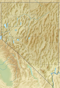
Spooner Lake is a man-made reservoir located just north of the intersection of Highway 50 and Highway 28 near Spooner Summit, a pass in the Carson Range of the Sierra Nevada leading to Carson City, Nevada from Lake Tahoe.[1] It is located in Lake Tahoe – Nevada State Park.
| Spooner Lake | |
|---|---|
| Spooner Reservoir | |
 Spooner Lake in April 2013 | |
 Spooner Lake | |
| Location | Carson Range of the Sierra Nevada, Nevada, United States |
| Coordinates | 39°06′25″N 119°54′31″W |
| Type | Reservoir |
| Settlements | Carson City, Nevada |
History
There are historical references to an "M. E. Spooner" and "Spooner & Co.'s House" in the area but the first documented eponymous reference was "a strip of productive land extends back from the lake for a distance of 2 miles, where it is called Spooner's Meadow".[2] A dam constructed in 1927 to store irrigation water converted the eastern part of Spooner Meadow into a small lake. Since the 1930s Spooner Lake has also been used for recreational fishing.[3]
Watershed and Geographical characteristics
The Spooner Lake watershed is approximately 1 square mile (2.6 km2) but peak flows from the lake are limited by Spooner Dam.[4] The dam was re-built in 1982 due to leakage.[5]
Spooner Lake is at 6,972 feet (2,125 m) above sea level.[1] It is fed by numerous seeps and snowmelt and its outflow below Spooner Dam is to North Canyon Creek in Spooner Meadow. North Canyon Creek then heads west and then northwest along Highway 28 before turning to the southwest and flowing down Slaughterhouse Canyon to Glenbook and Lake Tahoe. The creek flows through the Toiyabe National Forest on its journey to Lake Tahoe. The reservoir covers approximately 100 surface acres and has a maximum depth of 22 feet (6.7 m).[5]
Recreation
In 1973, the Nevada Department of Wildlife began stocking the Spooner Lake with trout.[6] Trout species include the native Lahontan cutthroat trout (Oncorhynchus clarkii henshawi), as well as multiple non-native species and hybrids including rainbow trout (Oncorhynchus mykiss), brown trout (Salmo trutta), bowcutt trout (rainbow x cutthroat), brook trout (Salvenlinus fontinalis), and tiger trout (brown x brook). However, the lake's shallowness has made trout overwintering difficult and native Lahontan tui chub (Gila bicolor) have come to dominate the lake's fish species.[3][6] Regulations changed from general (allowing harvest) to zero-harvest in 1982 and then to a 5 fish limit in 2006.[6]
Spooner Lake is also the start of a 5-mile hiking trail to Marlette Lake via North Canyon and the Tahoe Rim Trail.
See also
- Lake Tahoe - Nevada State Park
- Tahoe Rim Trail
References
- U.S. Geological Survey Geographic Names Information System: Spooner Lake
- Barbara Lekisch (1988). Tahoe Place Names: the Origin and History of Names in the Lake Tahoe Basin. Lafayette, California: Great West Books. p. 110. ISBN 9780944220016. Retrieved September 6, 2016.
- Jan Nemec (1 February 2010). Flyfisher's Guide to Nevada. Wilderness Adventures Press. pp. 61–. ISBN 978-1-932098-74-7.
- 2ndNature and Huffman & Carpenter, Inc. (April 2010). North Canyon Creek Restoration Project: Phase I Final Report (PDF) (Report). U.S. Army Corps of Engineers Sacramento District. Retrieved 5 September 2016.
{{cite report}}: CS1 maint: uses authors parameter (link) - Spooner Lake Federal Aid Progress Report (PDF) (Report). Nevada Department of Wildlife, Fisheries Division. 2012. Retrieved September 5, 2016.
- "Spooner Lake". Nevada State Parks. Retrieved September 5, 2016.
External links
 Media related to Spooner Lake at Wikimedia Commons
- Nevada State Parks - Spooner Lake
Другой контент может иметь иную лицензию. Перед использованием материалов сайта WikiSort.org внимательно изучите правила лицензирования конкретных элементов наполнения сайта.
WikiSort.org - проект по пересортировке и дополнению контента Википедии
