geo.wikisort.org - Reservoir
Tenaya Lake is an alpine lake in Yosemite National Park, located between Yosemite Valley and Tuolumne Meadows. The surface of Tenaya Lake has an elevation of 8,150 feet (2,484 m).[1] The lake basin was formed by glacial action, which left a backdrop of light granite rocks, whose beauty was known to the Native Americans. Today, Tenaya Lake is easily accessible by State Route 120 and is a popular lake for water activities.
| Tenaya Lake | |
|---|---|
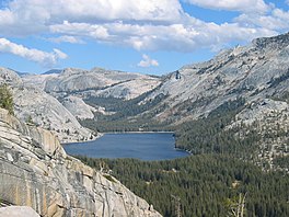 Tenaya Lake as seen from a hill northwest of the lake | |
 Tenaya Lake  Tenaya Lake | |
| Location | Yosemite National Park, Mariposa County, California, US |
| Coordinates | 37.8308°N 119.4583°W |
| Primary outflows | Tenaya Creek |
| Basin countries | United States |
| Surface elevation | 8,150 feet (2,484 m) |
History
Tenaya Lake is named after Chief Tenaya, who was the chief of the native people who lived in Yosemite Valley before being driven out by the Mariposa Battalion. Tenaya protested that the lake already had a name: Pie-we-ack, or "Lake of the Shining Rocks."[2] This original name is now attached to Pywiack Dome, a granite dome to the east of the lake.
As part of the 1864 Yosemite grant, the area became the first park land to be federally protected for preservation and public use. Yosemite became a national park in 1916 with the advent of the National Park Service.
In 1868, John Muir wrote about the Tenaya Lake's beauty and timelessness in My First Summer in the Sierra.[3]
Geology

Tenaya Lake was created by the Tenaya Glacier, which flowed out of the vast Tuolumne Ice Sheet and down to Yosemite Valley.[4] This same glacier created Half Dome.[5] The Tenaya Glacier was lightly loaded with debris, and did not leave a large amount of moraine material near Tenaya Lake.[6]
Hydrology
The lake is supplied by a network of creeks and springs including Murphy Creek to the northwest and Tenaya Creek. Tenaya Creek is an outflow of Cathedral Lakes and serves as both the principal inlet and outlet of Tenaya Lake. Tenaya Creek also runs through Tenaya Canyon into Yosemite Valley.
Access and use

Tenaya Lake can be accessed by car via Tioga Pass Road, which is called California State Route 120 outside the park. Visitors from the east must pass through the Tioga Pass Entrance on the eastern border of Yosemite National Park. Tioga Pass Road starts at the town Lee Vining on U.S. Route 395 140 miles (230 km) south of Reno and 330 miles (530 km) north of Los Angeles. Tioga Pass Road is closed by National Park Service during the winter months due to heavy snows. The connecting section to the east is closed by Caltrans when the park closes the entrance station for the winter.[7] The lake can be accessed by automobile from the west via Crane Flat, where the Tioga Pass Road meets the Big Oak Flat Road that connects the Big Oak Flat entrance (and CA120) to the park and Yosemite Valley (and CA41 and CA140).
According to the US National Park Service, problems associated with visitor use have been persistent for decades. The Park Service has commissioned The Tenaya Lake Area Plan, a formal study and action plan to address solutions to these issues.[8]
In 1992 a campground on the southwest shore of the lake was closed.[9]
Hiking is a popular activity. Trailheads that start at Tenaya Lake lead to Cathedral Lakes, Clouds Rest, Half Dome, and the Yosemite Valley floor.[10]
Fishing is permitted year-round at Yosemite National Park. Visitors over 16 require a valid California fishing license.[11] Various species of trout can be caught in the lake.[12]
Visitors can kayak, canoe, or sail on the lake. No formal launch facilities or docks are available, and motorized boats are not permitted.[13] Swimming is permitted.[14]
Conservancy
In 2011, $850,000 was earmarked for restoration of Tenaya lake habitat by the Yosemite Conservancy.[15] The program will reroute hiking trails away from sensitive wetlands.
See also
- List of lakes in California
References
- "Station Meta Data: Tenaya Lake". California Department of Water Resources. Retrieved October 11, 2005.
- Farquhar, Francis P. "Place Names – T". Place Names of the High Sierra. Retrieved October 11, 2005.
- Muir, John (1911). My First Summer in the Sierra. Houghton Mifflin.
- Matthes, François E. (1930). "Ancient Glaciers of the Yosemite Region". Glacial History of the Yosemite Valley. USGS. Professional Paper 160.
- Schoenherr, Allan A (1992). A Natural History of California. p. 90. ISBN 9780520069220.
- Matthes, François E. (1930). "Evidences of Glacial Action in the Yosemite Region". Glacial History of the Yosemite Valley. USGS. Professional Paper 160.
- "Current State Route 120 Conditions". Caltrans.
- "Yosemite National Park Tenaya Lake Area Plan". National Park Service. Retrieved October 14, 2009.
- "Tenaya Lake Campground, Central Sierra Nevada, California". Hikercentral. Retrieved October 14, 2009.
- "National Park Service Hiking Map".
- "California Department of Fish and Game-Fishing".
- "National Park Service Guide to Water Activities".
- "Gofishn.com-Fishing in Tenaya Lake". Archived from the original on 2011-10-03. Retrieved 2012-03-01.
- "National Park Services Guide to Water Activities".
- "Tenaya Lake Restoration: East Beach". Yosemite Conservancy.
External links
 Media related to Tenaya Lake at Wikimedia Commons
| Mountains |
| |||||||||||
|---|---|---|---|---|---|---|---|---|---|---|---|---|
| Passes |
| |||||||||||
| Rivers | ||||||||||||
| Lakes | ||||||||||||
| Protected areas |
| |||||||||||
| Communities | ||||||||||||
| Ski areas |
| |||||||||||
| Trails |
| |||||||||||

На других языках
[de] Tenaya Lake
Der Tenaya Lake ist ein See im Yosemite-Nationalpark im US-Bundesstaat Kalifornien. Er liegt zwischen dem Yosemite Valley und der Tuolumne-Wiese. Der See wurde durch den Tuolumne-Gletscher gebildet. Ausfluss des Sees ist der Tenaya Creek, der durch den Tenaya Canyon im Yosemite Valley fließt. Der See liegt auf einer Höhe von 2484 m über dem Meeresspiegel. Der See wurde nach Tenaya benannt, dem Häuptling der bei benachbarten Stämmen als Yosemite bekannten Ahwahnee (Ahwahneechee).- [en] Tenaya Lake
[es] Lago Tenaya
El lago Tenaya es un lago de Estados Unidos, situado en el estado de California.[fr] Lac Tenaya
Le lac Tenaya est un lac de montagne situé dans le parc national de Yosemite en Californie. Il tient son nom du chef amérindien Tenaya, mort en 1853.[it] Lago Tenaya
Il lago Tenaya è un lago alpino del parco nazionale di Yosemite, posto tra la valle di Yosemite e le Tuolumne Meadows, in California. Il lago, la cui bellezza era decantata dai Nativi Americani, si è formato per azione di un ramo del ghiacciaio Tuolumne durante il suo passaggio attraverso il Tenaya Canyon e si trova a 2 484 metri di altitudine. Il nome del lago deriva da Chief Tenaya, che incontrò il battaglione Mariposas nei pressi del lago. Oggi, il Tenaya Lake è facilmente raggiungibile tramite la strada statale Route 120 ed è un luogo di attrazione particolarmente popolare per le attività sull'acqua.[ru] Теная (озеро)
Теная[2] (англ. Tenaya Lake, Lake Ten-ie-ya, Py-we-ack, Yo-Semity Lake) — озеро в центральной части Калифорнии на западе США. Располагается в национальном парке Йосемити на территории округа Марипоса. Относится к бассейну реки Сан-Хоакин[1][2][3].Другой контент может иметь иную лицензию. Перед использованием материалов сайта WikiSort.org внимательно изучите правила лицензирования конкретных элементов наполнения сайта.
WikiSort.org - проект по пересортировке и дополнению контента Википедии