geo.wikisort.org - Reservoir
Lake Waiau[1] is a high-elevation lake located at 3,970 m (13,020 ft) above sea level on Mauna Kea, on the island of Hawaiʻi. It is arguably one of the highest lakes in the United States.[2][3] After the evaporation of Ka Wai o Pele in 2018 and the short-lived lake in Halema'uma'u crater in 2020, Lake Waiau is the only lake on Hawaiʻi Island and one of very few lakes at all in the state of Hawaiʻi. It is relatively small, only about 100 m across, and varies in size as the water level rises and falls. At high water levels a small outlet stream appears at the northwest end, but it is absorbed into the ground after a short distance. The name means "swirling water" in Hawaiian, though it is usually rather placid. It usually freezes in winter, but aquatic insects such as midges and beetles can be found breeding in the water.
| Lake Waiau | |
|---|---|
 | |
 Lake Waiau  Lake Waiau | |
| Location | Mauna Kea, Hawaii |
| Coordinates | 19.81125°N 155.47743°W |
| Catchment area | 13.5 ha (33 acres) |
| Basin countries | United States |
| Max. width | 100 m (330 ft) |
| Surface area | 6,000 m2 (65,000 sq ft) |
| Max. depth | 2–2.5 m (6.6–8.2 ft) |
| Surface elevation | 3,970 m (13,020 ft) |
Description
Lake Waiau is located inside the Pu'u Waiau cinder cone at an altitude of 3970 m. It is approximately heart shaped and its diameter reaches about 100 m. The average surface area of the lake is around 6,000 m2 (65,000 sq ft; 0.60 ha; 1.5 acres). The size of its surface area fluctuates significantly over the year. It reaches its peak during spring with a maximal depth between 2 m and 2.5 m. By the end of the summer, it often has shrunk to one third of its original size with a maximal depth below 1 m. A spillover into the Pohakuloa Gulch occurs when the lake depth is more than 2.3 m. The lake is only fed by precipitation, which occurs primarily during the winter; its catchment area is about 135,000 m2 (1,450,000 sq ft; 13.5 ha; 33 acres), mostly located within the Pu'u Waiau cinder cone.[2]
The lake is an anomaly in the peak region of Mauna Kea as everywhere else the ground is unable to retain water. The exact nature of the impermeable ground layer of the lake is still unknown. It is assumed that fine-grained densely compressed ash, basalt rock or a small permafrost layer may play a role. No permafrost layer has been established so far for the lake area itself, but it was found at another location in the peak area. The bottom of the lake, however, is known to have a 7.5-metre (25 ft) thick sediment layer.[2][4]
Temporary shrinkage 2010-2014
Between 2010 and 2013 the lake shrank significantly. On 26 September 2013, the lake had been reduced to a mere puddle of less than 2% of its original surface size, with a reported width of 9 m (10 yd) and maximum depth of 23 cm (9 in). By December 2013, three months later, the maximum depth had dropped further to 13 cm (5 in).[5]
The exact causes for the water loss are unknown. The suspects are drought conditions and the thawing of an assumed permafrost layer under the lake leading to increased seepage.[6]
After the particularly wet winter of 2013/2014, however, the lake was back to around 75% of its original size by May 2014, and subsequently returned to its normal size. The drought conditions on Mauna Kea from 2010 to 2013 are currently believed to have been the primary reason for the water loss.[7][8]
Mythology
The lake is of some importance in Hawaiian mythology. Aside from Poliʻahu, there are two additional snow deities, Lilinoe and Waiau, who are associated with Mauna Kea, and according to Westervelt, the lake was probably named after the goddess of the same, who used to bathe in it. Originally Hawaiians considered the whole peak region of Mauna Kea, including Lake Waiau, a sacred site, and only priests and chieftains were allowed to access it. Later, after the formation of the Hawaiian kingdom, the peak region was occasionally visited by members of the royal family. The last one to do so was Queen Emma in 1881, who also took a bath in the lake during her visit.[9][10]
Gallery
 view from above
 with a person for scale
 outlet stream
 Shrinkage October 2012
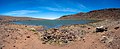 May 26, 2019


See also
- List of lakes in Hawaii
References
- U.S. Geological Survey Geographic Names Information System: Lake Waiau
- Ehlmann, Bethany L.; Raymond Arvidson,; Bradley Jolliff,; Sarah Johnson,; Brian Ebel,; Nicole Lovenduski,; Julie Morris,; Jeffery Byers,; Nathan Snider,; Robert Criss,. Hydrologic and isotopic modeling of alpine Lake Waiau, Mauna Kea, Hawai'i. (1). Pacific Science. 2005. HighBeam Research. (February 16, 2014). http://www.highbeam.com/doc/1G1-129714347.html Archived 2014-06-11 at the Wayback Machine
- "The Highest Lake in the USA". Retrieved 2008-10-11.
- Alan C. Ziegler: Hawaiian Natural History, Ecology, and Evolution. University of Hawaii Press, 2002, ISBN 0824821904, S. 94 (excerpt, p. 94, at Google Books)
- Jensen, Chelsea (2020-07-25). Lake Waiau remains full. West Hawaii Today, 25 July 2020. Retrieved from https://www.westhawaiitoday.com/2020/07/25/hawaii-news/lake-waiau-remains-full-2/.
- Disappearing Lake Waiau Is a Mystery to Scientists. Honolulu Star – Advertiser. 2013. (February 16, 2014). [dead link]
- Erin Miller: On the rise: Lake Waiau benefits from wetter weather Archived 2014-08-20 at the Wayback Machine. Hawaii Tribune Herald, 30. Mai 2014
- Jensen, Chelsea (2017-03-22). "Lake Waiau atop Mauna Kea nearly full or full since fall 2014". West Hawaii Today. Archived from the original on 2017-03-29.
- Hawaiian Culture & Mauna Kea Archived 2014-02-22 at archive.today auf den Webseiten der Mauna Kea Visitor Information Station; retrieved, 22 February 2014)
- H. Arlo Nimmo: Pele, Volcano Goddess of Hawai'i: A History. McFarland, 2011, ISBN 9780786463473, S. 28 (excerpt, p. 28, at Google Books)
Bibliography
- Jane Ellen Massey: Lake Waiau: A Study of a Tropical Alpine Lake, Past and Present. University of Hawaii Press, 1978
- Alfred H. Woodcock, Meyer Rubin, R. A. Duce: Deep Layer of Sediments in Alpine Lake in the Tropical Mid-Pacific. Science, New Series, Vol. 154, No. 3749 (Nov. 4, 1966), pp. 647–648 (JSTOR)
External links
- Impermeable beds trap rain and snow at Mauna Kea's Lake Waiau. Hawaiian Volcano Observatory, 2003-06-19
- Volcano Watch: Lake Waiau is shrinking fast at Hawaii 24/7
- Lake Waiau, Hawaii, USA at lakelubbers.com
- Mauna Kea – The Hike To Lake Waiau at instanthawaii.com
- Lake Waiau (archived)
На других языках
[de] Lake Waiau
Der Lake Waiau[2] ist ein kleiner alpiner Bergsee, der sich unterhalb des Gipfels des Mauna Kea auf Hawaii befindet. Nach dem Verdampfen des Green Lake durch einen Lavastrom des Kīlauea-Ausbruchs im Mai 2018 ist er der einzige verbliebene Süßwassersee der Insel.- [en] Lake Waiau
[fr] Lac Waiʻau
Le lac Waiʻau est un lac de cratère situé à 3 970 m d'altitude dans le fond du cône volcanique Puʻu Waiʻau, au sommet du Mauna Kea, sur l'île d'Hawaï dans l'État du même nom. Il constitue le septième plus haut lac des États-Unis[1] et le plus haut du bassin pacifique. Il fait environ 100 mètres de diamètre mais varie en fonction des précipitations. Lorsque le niveau du lac augmente, un petit émissaire se forme à son extrémité septentrionale mais celui-ci est absorbé dans le sol au bout de quelques dizaines de mètres. Son nom signifie « eau tourbillonnante » en hawaïen, bien qu'il soit généralement peu agité. Il est fréquemment gelé en hiver mais des insectes aquatiques peuvent se trouver dans ses environs.[ru] Ваиау (озеро)
Ваиау[4] (гав. Waiau, англ. Lake Waiau[2], Waiau Pond[2]) — маленькое высокогорное озеро в округе Гавайи, штат Гавайи, США[2].Другой контент может иметь иную лицензию. Перед использованием материалов сайта WikiSort.org внимательно изучите правила лицензирования конкретных элементов наполнения сайта.
WikiSort.org - проект по пересортировке и дополнению контента Википедии