geo.wikisort.org - Mountains
The Mönch (German pronunciation: [ˈmœnç] (![]() listen), German: "monk") at 4,110 metres (13,480 ft) is a mountain in the Bernese Alps, in Switzerland. Together with the Eiger and the Jungfrau, it forms a highly recognisable group of mountains, visible from far away.
listen), German: "monk") at 4,110 metres (13,480 ft) is a mountain in the Bernese Alps, in Switzerland. Together with the Eiger and the Jungfrau, it forms a highly recognisable group of mountains, visible from far away.
| Mönch | |
|---|---|
 The Mönch north face dominating the Eiger Glacier (which flows from left to right). | |
| Highest point | |
| Elevation | 4,110 m (13,480 ft) |
| Prominence | 591 m (1,939 ft)[1] |
| Parent peak | Finsteraarhorn |
| Isolation | 3.6 km (2.2 mi)[2] |
| Coordinates | 46°33′30″N 7°59′50″E |
| Naming | |
| English translation | Monk |
| Geography | |
 Mönch Location in Switzerland | |
| Location | Bern/Valais, Switzerland |
| Parent range | Bernese Alps |
| Geology | |
| Mountain type | Limestone |
| Climbing | |
| First ascent | August 15, 1857 |
| Easiest route | basic rock/snow/ice climb |
The Mönch lies on the border between the cantons of Valais and Bern, and forms part of a mountain ridge between the Jungfrau and Jungfraujoch to the west, and the Eiger to the east. It is west of Mönchsjoch, a pass at 3,650 metres (11,980 ft), Mönchsjoch Hut, and north of the Jungfraufirn and Ewigschneefäld, two affluents of the Great Aletsch Glacier. The north side of the Mönch forms a step wall above the Lauterbrunnen valley.
The Jungfrau railway tunnel runs right under the summit, at an elevation of approximately 3,300 metres (10,830 ft).
The summit was first climbed on 15 August 1857 by Christian Almer, Christian Kaufmann (1831-1861), Ulrich Kaufmann and Sigismund Porges.
Gallery
 A view of the Mönch taken from the Jungfraujoch
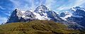
 The Moench, by Helga von Cramm, with prayer by Achespè, chromolithograph, c. 1879. (3 x 4.5 inches).


See also
- List of 4000 metre peaks of the Alps
References
- Retrieved from the Swisstopo topographic maps. The key col is the Unders Mönchsjoch (3,519 m).
- Retrieved from Google Earth. The nearest point of higher elevation is northeast of the Jungfrau.
External links
- Mönch on Summitpost
- Mönch on Hikr
- "Mönch". Peakware.com. Archived from the original on 2016-03-04. - photos
- Mönch from Kleine Scheidegg
This Valais location article is a stub. You can help Wikipedia by expanding it. |
This Canton of Bern location article is a stub. You can help Wikipedia by expanding it. |
На других языках
[de] Mönch (Berg)
Der Mönch ist ein 4107 m ü. M. hoher Berg der Berner Alpen in der Schweiz. Zusammen mit dem Eiger und der Jungfrau bildet er eine markante, von weit her sichtbare Dreiergruppe, ein sogenanntes „Dreigestirn“.- [en] Mönch
[es] Mönch
Mönch (en alemán monje) es una montaña ubicada en los Alpes berneses, al sur del cantón de Berna en Suiza. Las localidades de Wengen (Lauterbrunnen) y Grindelwald, que se encuentran a los pies de la montaña, son muy conocidas por los amantes del montañismo y los deportes de invierno.[fr] Mönch
Le Mönch est un sommet individualisé situé en Suisse dans les Alpes bernoises.[it] Mönch
Il Mönch (4.105 m) è una montagna svizzera delle Alpi bernesi, situata tra il Canton Berna ed il Canton Vallese, vicino all'Eiger e allo Jungfrau, formando una triade particolarmente nota nel mondo dell'alpinismo.[ru] Мёнх
Мёнх (нем. Mönch — монах) — горная вершина в Бернских Альпах.Другой контент может иметь иную лицензию. Перед использованием материалов сайта WikiSort.org внимательно изучите правила лицензирования конкретных элементов наполнения сайта.
WikiSort.org - проект по пересортировке и дополнению контента Википедии