geo.wikisort.org - Mountains
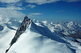
The Rimpfischhorn (4,199 m) is a mountain in the Pennine Alps of Switzerland.
| Rimpfischhorn | |
|---|---|
 The Rimpfischhorn from the Allalinhorn | |
| Highest point | |
| Elevation | 4,199 m (13,776 ft) |
| Prominence | 635 m (2,083 ft)[1] |
| Parent peak | Dom |
| Isolation | 4.7 km (2.9 mi) |
| Coordinates | 46°01′23″N 7°53′02″E |
| Geography | |
| Location | Valais, Switzerland |
| Parent range | Pennine Alps |
| Climbing | |
| First ascent | 9 September 1859 by Leslie Stephen and Robert Liveing with guides Melchior Anderegg and Johann Zumtaugwald |
| Easiest route | Allalin glacier/north-west ridge (PD); a snow climb. |
The first ascent of the mountain was by Leslie Stephen and Robert Living with guides Melchior Anderegg and Johann Zumtaugwald on 9 September 1859. Their route of ascent was from Fluh Alp via the Rimpfischwänge.
See also
- List of 4000 metre peaks of the Alps
| Wikimedia Commons has media related to Rimpfischhorn. |
References
- Retrieved from the Swisstopo topographic maps. The key col is the Allalinpass (3,564 m).
External links
На других языках
[de] Rimpfischhorn
Das Rimpfischhorn ist ein Viertausender in den Walliser Alpen im Gebiet zwischen der Monte-Rosa-Gruppe im Süden und der Mischabel-Gruppe im Norden. Ausgangsorte für die Besteigung sind Zermatt oder Saas Fee.- [en] Rimpfischhorn
[fr] Rimpfischhorn
Le Rimpfischhorn est un sommet des Alpes valaisannes à 4 199 mètres d'altitude, accessible depuis Zermatt ou Saas Fee.[it] Rimpfischhorn
Il Rimpfischhorn (4.199 m s.l.m.[1]) è una montagna svizzera delle Alpi Pennine nel Massiccio del Mischabel.[ru] Римпфишхорн
Римпфишхорн (нем. Rimpfischhorn) — гора-четырёхтысячник в Швейцарии.Текст в блоке "Читать" взят с сайта "Википедия" и доступен по лицензии Creative Commons Attribution-ShareAlike; в отдельных случаях могут действовать дополнительные условия.
Другой контент может иметь иную лицензию. Перед использованием материалов сайта WikiSort.org внимательно изучите правила лицензирования конкретных элементов наполнения сайта.
Другой контент может иметь иную лицензию. Перед использованием материалов сайта WikiSort.org внимательно изучите правила лицензирования конкретных элементов наполнения сайта.
2019-2025
WikiSort.org - проект по пересортировке и дополнению контента Википедии
WikiSort.org - проект по пересортировке и дополнению контента Википедии
