geo.wikisort.org - Mountains
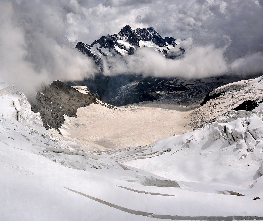
The Schreckhorn (4,078 m) is a mountain in the Bernese Alps. It is the highest peak located entirely in the canton of Berne. The Schreckhorn is the northernmost Alpine four-thousander and the northernmost summit rising above 4,000 metres in Europe.
| Schreckhorn | |
|---|---|
 The Schreckhorn from the north | |
| Highest point | |
| Elevation | 4,078 m (13,379 ft) |
| Prominence | 795 m (2,608 ft)[1] |
| Parent peak | Finsteraarhorn |
| Isolation | 5.5 km (3.4 mi)[2] |
| Coordinates | 46°35′23.9″N 8°07′05.3″E |
| Naming | |
| English translation | Peak of terror[3] |
| Geography | |
 Schreckhorn Location in Switzerland | |
| Location | Canton of Bern, Switzerland |
| Parent range | Bernese Alps |
| Climbing | |
| First ascent | 16 August 1861 by Leslie Stephen and party |
| Normal route | south-west ridge |
Geography
The Schreckhorn is located 10 km south-east of Grindelwald between the Upper and Lower Grindelwald Glacier. The region is made up of uninhabited glacial valleys, the great Aar Glaciers and the Fiescher Glacier. The summit of the Lauteraarhorn is located very close and reaches almost the same altitude. The highest peak of the Bernese Alps, the Finsteraarhorn lies 6 km to the south.
Geologically the Schreckhorn is part of the Aarmassif.
Climbing history
The first ascent was on 16 August 1861 by Leslie Stephen, Ulrich Kaufmann, Christian Michel and Peter Michel. Their route of ascent, via the upper Schreck Couloir to the Schrecksattel and then by the south-east ridge, was the normal route for the following fifty years, but is now seldom used.
The peak had been attempted several times before this, most notably by the Swiss naturalist Joseph Hugi in 1828 and the guided party of Pierre Jean Édouard Desor (a Swiss geologist) in 1842. 'The ambition of hoisting the first flag on the Schreckhorn, the one big Bernese summit which was untrodden, was far too obvious for us to resist', Desor later wrote, but they climbed a secondary summit of the Lauteraarhorn by mistake.
The first ascent by the south-west ridge (AD+) – the normal route by which the Schreckhorn is climbed – was made by John Wicks, Edward Branby and Claude Wilson on 26 July 1902. They decided to climb the very steep ridge without the help of local guides and succeeded in reaching the summit. The north-west ridge (the Andersongrat, D) was first climbed by John Stafford Anderson and George Percival Baker, with guides Ulrich Almer and Aloys Pollinger on 7 August 1883.[4]

The Strahlegg Hut, destroyed by an avalanche, has been replaced by the Schreckhorn Hut (2,520 m). The Schreckhorn may also be ascended from the Gleckstein Hut (2,317 m) and the Lauteraar Hut (2,392 m).
See also
- List of 4000 metre peaks of the Alps
References
- Retrieved from the Swisstopo topographic maps. The key col is the Finsteraarjoch (3,283 m).
- Retrieved from Google Earth. The nearest point of higher elevation is northwest of the Finsteraarhorn.
- Fergus Fleming, Killing Dragons, Granta Books, 2011
- Helmut Dumler,Willi P. Burkhardt, Les 4000 des Alpes, ISBN 2-7003-1305-4
- Dumler, Helmut and Willi P. Burkhardt, The High Mountains of the Alps, London: Diadem, 1994
- Engel, Claire: Mountaineering in the Alps, London: George Allen and Unwin, 1971
Further reading
- Smythe, Frank S., 'A Storm on the Schreckhorn', in Peaks, Passes and Glaciers, ed. W. Unsworth, London: Allen Lane, 1981. An attempt on the south-west ridge in 1925.
External links
| Wikimedia Commons has media related to Schreckhorn. |
- The Schreckhorn on SummitPost
- Sunset on the Schreckhorn
- Paragliding around the Schreckhorn
- Schreckhorn in beautiful evening light
- Schreckhorn reflected in the Bachalpsee
| Authority control |
|
|---|
На других языках
[de] Schreckhorn
Das Schreckhorn ist mit einer Höhe von 4078 m ü. M. der nördlichste Viertausender Europas. Es befindet sich in den Berner Alpen im Kanton Bern in der Schweiz. Geologisch gehört das Schreckhorn zum Aarmassiv und besteht aus Erstfeldergneis.- [en] Schreckhorn
[es] Schreckhorn
El Schreckhorn (literalmente Pico[1] o Cuerno del miedo) es una cima de 4.078 msnm, considerada por los especialistas como una de las más difíciles de los Alpes berneses aunque no sea la más alta. El Schreckhorn es también la montaña más alta enteramente dentro del cantón de Berna.[fr] Schreckhorn
Le Schreckhorn est le sommet de plus de 4 000 m considéré par les spécialistes comme l'un des plus difficiles des Alpes bernoises, voire des Alpes suisses. Le Schreckhorn n'est pourtant pas la plus haute montagne du canton de Berne (4 078 m), largement dépassée par son voisin le Finsteraarhorn (4 274 m). Il est le plus septentrional des « 4 000 alpins ».[it] Schreckhorn
Lo Schreckhorn (4.078 m s.l.m.) è una montagna svizzera delle Alpi Bernesi. Si trova nel Canton Berna.[ru] Шрекхорн
Шрекхо́рн (нем. Schreckhorn) — гора в Бернских Альпах, в кантоне Берн, Швейцария. Это высочайшая из гор, находящихся полностью на территории кантона Берн. Её высота — 4078 метров над уровнем моря.Другой контент может иметь иную лицензию. Перед использованием материалов сайта WikiSort.org внимательно изучите правила лицензирования конкретных элементов наполнения сайта.
WikiSort.org - проект по пересортировке и дополнению контента Википедии