geo.wikisort.org - Reservoir
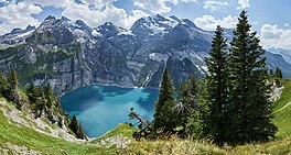
Oeschinen Lake (German: Oeschinensee) is a lake in the Bernese Oberland, Switzerland, 4 kilometres (2.5 mi) east of Kandersteg in the Oeschinen valley. At an elevation of 1,578 metres (5,177 ft), it has a surface area of 1.1147 square kilometres (0.4304 sq mi). Its maximum depth is 56 metres (184 ft).
| Oeschinen Lake | |
|---|---|
 Oeschinen Lake from Heuberg. View towards the Blüemlisalp and the Doldenhorn. | |
| Location | Kandersteg, Bernese Oberland |
| Coordinates | 46°29′54″N 07°43′37″E |
| Type | oligotrophic, holomictic |
| Primary inflows | Bärglibach, Wyssbach, Lägerbach, Oeschinenbach |
| Primary outflows | underground |
| Catchment area | 22 km2 (8.5 sq mi) |
| Basin countries | Switzerland |
| Max. length | 1.6 km (0.99 mi) |
| Max. width | 1 km (0.62 mi) |
| Surface area | 1.1147 km2 (0.4304 sq mi) |
| Average depth | 34 m (112 ft) |
| Max. depth | 56 m (184 ft) |
| Residence time | 1.61 years |
| Surface elevation | 1,578 m (5,177 ft) |
| Frozen | December to May |
 | |
The lake was created by a giant landslide and is fed through a series of mountain creeks and drains underground. The water then resurfaces as the Oeschibach. Part of it is captured for electricity production and as water supply for Kandersteg.
In observations from 1931 to 1965, the elevation of the lake surface varied between 1,566.09 metres (5,138.1 ft) and 1,581.9 metres (5,190 ft). The average seasonal variation was 12.2 metres (40 ft) (September/April).
The lake is generally frozen during five months, from December to May. From time to time ice skating is possible on the ice.
Fish in the lake include Arctic char (Seesaibling), lake trout (Kanadische Seeforelle), rainbow trout (Regenbogenforelle). From January to March, ice fishing is popular.
A gondola lift from Kandersteg leads to Oeschinen, 25 minutes by foot from the lake.
Since 2007 the lake is part of the Jungfrau-Aletsch-Bietschhorn UNESCO World Heritage Site.
As of summer 2021, a circumnavigation of Lake Oeschinen is not possible. The reason for this is the danger of an imminent rockfall on the south shore, which is why paths are closed there.[1]
See also
References
- Christian Holzer. "Beliebter Oeschinensee wegen drohendem Felsabbruch teilgesperrt". Retrieved 13 October 2021.
- Fischerei im Oeschinensee (in German and French)
- Niklaus, Markus (1967), Geomorphologische und Limnologische Untersuchungen am Oeschinensee (in German), Thun: Ott
External links
На других языках
[de] Oeschinensee
Der Oeschinensee liegt oberhalb von Kandersteg (Berner Oberland) in der Schweiz. Der Wasserspiegel liegt durchschnittlich auf einer Höhe von 1578 m. Der See ist bei normalem Wasserstand 56 m tief und hat eine Fläche von 1,1 km², womit er zu den grösseren Bergseen in der Schweiz gehört. Er entstand durch mehrere Bergrutsche der Flanken des Fründenhorns und des Doldenhorns.- [en] Oeschinen Lake
[fr] Lac d'Oeschinen
Le lac d'Oeschinen (en allemand : Oeschinensee) est un lac des Alpes bernoises en Suisse.[it] Lago di Oeschinen
Il lago di Oeschinen (in tedesco: Oeschinensee) è un lago della Svizzera centrale, situato nel Canton Berna.[ru] Эшинен-Зе
Эшинен-Зе[2][3] (Эшинензее[4]; нем. Oeschinensee[1]) — озеро в Швейцарии[2]. Расположено в Бернских Альпах[3] в кантоне Берн[2] на территории коммуны Кандерштег[5].Другой контент может иметь иную лицензию. Перед использованием материалов сайта WikiSort.org внимательно изучите правила лицензирования конкретных элементов наполнения сайта.
WikiSort.org - проект по пересортировке и дополнению контента Википедии


