geo.wikisort.org - Mountains
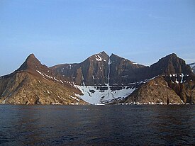
The Kaumajet Mountains are a dramatic compact mountain range rising directly out of the sea on the northern Labrador coast. The mountain range has one 4,000-foot (1,200 m) peak, the highest island peak on the east coast of North America between the Caribbean and Hudson Strait, and several peaks with very high prominence[clarification needed]. The highest mountain in the Kaumajet Mountains is Brave Mountain at 1,300 m (4,265 ft).
| Rank | Name | m | ft |
|---|---|---|---|
| 1 | Brave Mountain | 1300 | 4265 |
| 2 | Bishop's Mitre | 1113 | 3652 |
| 3 | The Finger | 1006+ | 3300+ |
| 4 | Peak 3300 (14F/13) | 1006+ | 3300+ |
| 5 | Cod Island High Point | 914+ | 3000+ |
| 6 | Cod Island Peak | 823+ | 2700+ |
| 7 | Cod Island Peak | 792+ | 2600+ |
| 8 | Drachart Island High Point | 726+ | 2500+ |
| Kaumajet Mountains | |
|---|---|
 Bishop's Mitre in the Kaumajet Mountains | |
| Highest point | |
| Peak | Brave Mountain |
| Elevation | 1,300 m (4,300 ft) |
| Coordinates | 57°52′59.9″N 62°01′59.9″W |
| Geography | |
| Country | Canada |
| Region | Labrador |
| Range coordinates | 57°48′N 61°51′W |
| Parent range | Arctic Cordillera |
See also
- List of mountain ranges
External links
- "Kaumajet Mountains". Peakbagger.com.
На других языках
- [en] Kaumajet Mountains
[fr] Monts Kaumajet
Les monts Kaumajet[2] sont une chaîne de montagnes faisant partie de la cordillère Arctique dans le bouclier canadien et située sur la péninsule du Labrador, dans la province de Terre-Neuve-et-Labrador.Текст в блоке "Читать" взят с сайта "Википедия" и доступен по лицензии Creative Commons Attribution-ShareAlike; в отдельных случаях могут действовать дополнительные условия.
Другой контент может иметь иную лицензию. Перед использованием материалов сайта WikiSort.org внимательно изучите правила лицензирования конкретных элементов наполнения сайта.
Другой контент может иметь иную лицензию. Перед использованием материалов сайта WikiSort.org внимательно изучите правила лицензирования конкретных элементов наполнения сайта.
2019-2025
WikiSort.org - проект по пересортировке и дополнению контента Википедии
WikiSort.org - проект по пересортировке и дополнению контента Википедии