geo.wikisort.org - Mountains
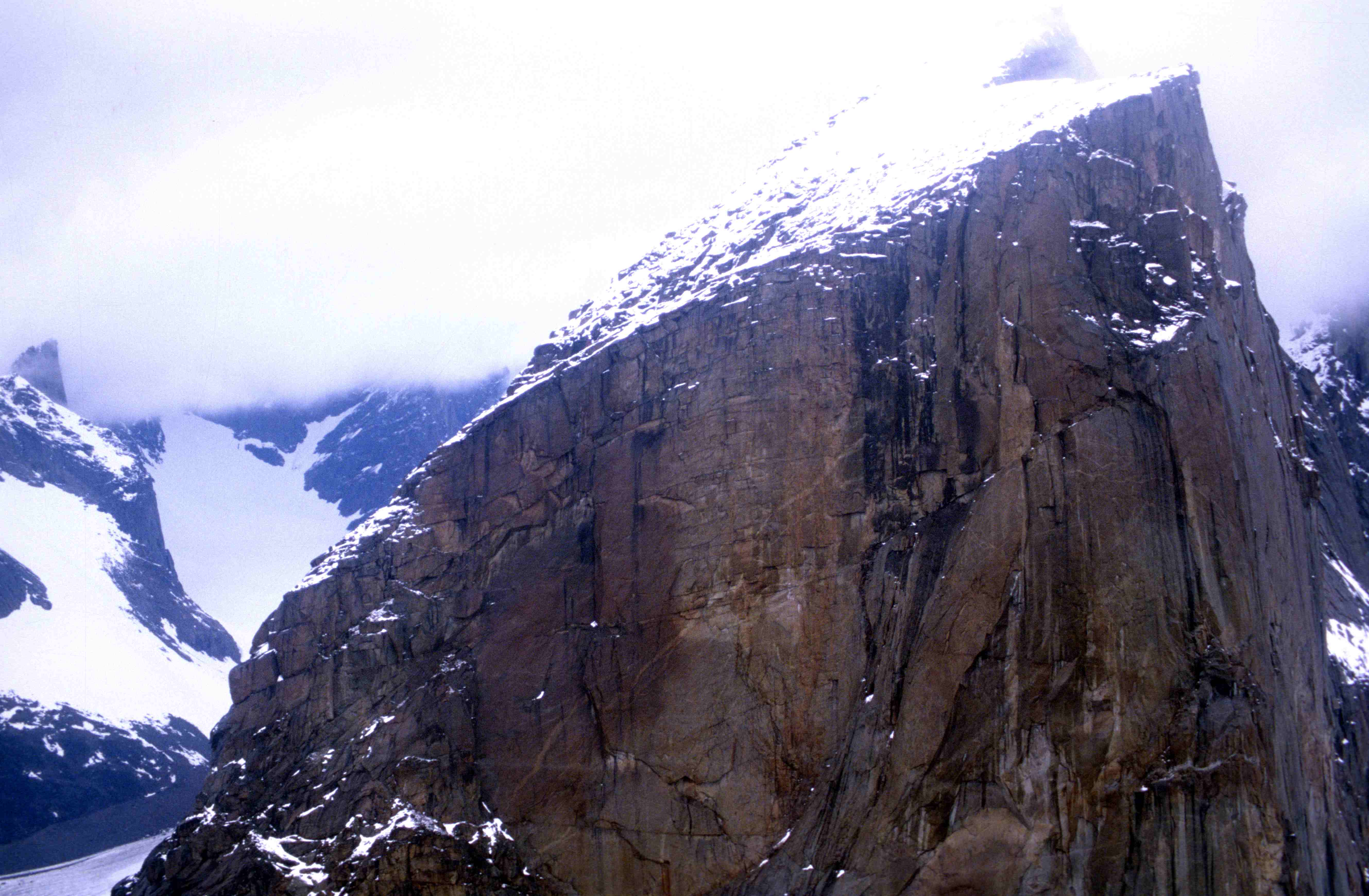
Mount Thor, officially gazetted as Thor Peak (Inuktitut: ᙯᕐᓱᐊᓗᒃ Qaisualuk "huge bedrock"[3][4] or Inuktitut: ᑭᒍᑎᙳᐊᖅ Kigutinnguaq "tooth-like"[3][5]), is a mountain with an elevation of 1,675 m (5,495 ft) located in Auyuittuq National Park, on Baffin Island, Nunavut, Canada. The mountain is located 46 km (29 mi) northeast of Pangnirtung and features Earth's greatest vertical drop of 1,250 m (4,100 ft), with the cliff overhanging at an average angle of 15 degrees from vertical.[6] Despite its remoteness, this feature makes the mountain a popular rock climbing site. Camping is allowed, with several designated campsites located throughout the length of Akshayuk Pass. For climbers looking to scale Mount Thor, there is an established campsite a few kilometres north of its base, complete with windbreaks and emergency shelters.
| Mount Thor | |
|---|---|
| Thor Peak, Qaisualuk, Kigutinnguaq | |
 Mount Thor seen from Akshayuk Pass | |
| Highest point | |
| Elevation | 1,675 m (5,495 ft)[1] |
| Coordinates | 66°32′N 65°19′W[1][2] |
| Naming | |
| Native name |
|
| Geography | |
 Mount Thor Nunavut, Canada | |
| Parent range | Baffin Mountains |
| Topo map | NTS 26I11 Mount Asgard |
| Climbing | |
| First ascent | Morton and Spitzer, 1965 |
The English naming of the mountain originates from Thor, the Norse thunder god.[7]
Geography
Mount Thor is part of the Baffin Mountains which in turn form part of the Arctic Cordillera mountain range. The mountain consists of granite.[1]
Geology
This mountain consists of solid granite. The rock making up this formation have been metamorphosed multiple times through earth's history, causing this granitic layer to be pushed through other layers. The age of the rock ranges from 570 million years to 3.5 billion years (Pre-Cambrian), making it some of the oldest rock on earth. [8]
The peak and vertical drop itself are a product of glacial erosion, carved over millennia by seasonal glacial activity through the Akshayuk Pass, on the rim of which this mountain sits. Like other glacial channels, this pass has the characteristic U-shape which gives the mountain its vertical drop[9]
 |
 |
 |
 |
Ascents
Donald Morton and Lyman Spitzer made the first recorded ascent of Mount Thor in 1965 during the Alpine Club of Canada expedition led by Pat Baird.[10]: 347 [11] Pat Baird also led the 1953 geophysical expedition during which Hans Weber, J. Rothlisberger and F. Schwarzenbach climbed the North Tower of Mount Asgard for the first time.
The first ascent of the west face was achieved by Earl Redfern, John Bagley, Eric Brand and Tom Bepler in 1985.[12] The first solo ascent of the West Face was completed by Jason 'Singer' Smith in 1998. The first free climb of the Southwest Buttress was made in 2012 by Bill Borger and John Furneaux.[13][14]
See also
- Trango Towers – the tallest near-vertical drop on Earth
- Cerro Torre
- Half Dome
References
- "Thor Peak". Bivouac.com. Retrieved 2009-11-30.
- "Thor Peak". Geographical Names Data Base. Natural Resources Canada.
- "Qairsualuk". ᐃᓄᒃᑎᑐᑦ ᐃᓕᓐᓂᐊᖅᑕ. inuktitutilinniaqta.com. 31 May 2018. Retrieved 3 July 2020.
- Slaymaker, Olav; Catto, Norm (2020). Landscapes and Landforms of Eastern Canada. Springer Nature. p. 4. ISBN 978-3-030-35137-3. Retrieved 3 July 2020.
- Wykes, Tim. "ᐸᓐᓂᖅᑑᖅ Pangnirtung" (PDF). ihti.ca/. Inuit Heritage Trust. Retrieved 3 July 2020.
ᒥ4.2 ᑭᒍᑎᙳᐊᖅ Kigutinnguaq Mountain Looks like a tooth, Mount Thor
- "Mount Thor -The Greatest Vertical Drop on Earth!". The Daily Galaxy. March 9, 2010. Retrieved 2014-08-21.
- Jennings, Ken (10 June 2013). "Meet Canada's Mount Thor: The World's Steepest, Tallest Cliff". Conde Nast Traveler. Retrieved 18 April 2015.
- "The Earth Story - geologic blog".
- "Mount Thor, Baffin Island post by Brian John".
- Ostriker, J. P. (2007). "Lyman Spitzer. 26 June 1914 -- 31 March 1997: Elected ForMemRS 1990". Biographical Memoirs of Fellows of the Royal Society. 53: 339–348. doi:10.1098/rsbm.2007.0020.
- Morton, Donald C. (1966). "Mt. Asgard And Mt. Thor". Canadian Alpine Journal. 49: 42–48.
- Redfern, Earl (December 1995), "-Mount Thor - 33 Days on the West Face", Climbing Magazine (93): 34–36, ISSN 0045-7159
- "Climber Bill Borger". Radio Canada. July 24, 2012. Retrieved 2012-08-28.
- Hummel, Will (August 3, 2012), "New route on Baffin Island's Mount Thor", Rock and Ice, archived from the original on 2012-08-08, retrieved 2012-08-28
External links
- Above the Arctic Circle: Trekking across Canada's Baffin Island at the Wayback Machine (archived 2009-01-30) about Mt. Thor and other Akshayuk Pass features by writer Dave Levinthal
На других языках
[de] Mount Thor
Mount Thor ist ein Berg im Auyuittuq-Nationalpark auf Baffin Island, Nunavut, Kanada. Am Berg befindet sich die höchste mindestens senkrechte Steilwand der Welt. Sie misst 1250 Meter und weist einen Durchschnittswinkel von 105 Grad auf.- [en] Mount Thor
[fr] Mont Thor
Le mont Thor (en anglais Mount Thor ou Thor Peak) est une montagne granitique dans le parc national d'Auyuittuq sur l'île de Baffin dans le territoire canadien du Nunavut. La montagne est située à 46 km au nord-est de Pangnirtung et est l'une des parois rocheuses verticales les plus pures avec 1 250 mètres de rempart avec un angle moyen de 105 degrés.[it] Monte Thor
Il monte Thor, ufficialmente Thor Peak, è una montagna situata all'interno dell'Auyuittuq National Park, sull'isola di Baffin, nel territorio del Nunavut in Canada[1]. Ha un'altezza di 1675 metri e si trova a 46 km a nord-est di Pangnirtung[2]. La caratteristica principale della montagna è quella di presentare la parete verticale più elevata del mondo, alta 1250 metri e con un'inclinazione media di 105° [1]. Il monte fa parte della catena montuosa dei monti Baffin che a loro volta fanno parte della Cordigliera Artica. Il monte Thor venne scalato per la prima volta nel 1953 da una squadra dell'Arctic Institute of North America. I membri del team furono Hans Weber, J Rothlisberger e F. Schwarzenbach. Gli stessi uomini scalarono la Torre Nord del monte Asgard (anche questa per la prima volta)[3].[ru] Тор (гора)
Тор (англ. Mount Thor, инуктитут ᙯᕐᓱᐊᓗᒃ Qaisualuk[2][3] или ᑭᒍᑎᙳᐊᖅ Kigutinnguaq[2]), также известная как пик Тор (англ. Thor Peak) — горная вершина на острове Баффинова Земля. Расположена в национальном парке Ауюиттук, в 46 км к северо-востоку от Пангниртунга. Высота над уровнем моря составляет 1675 метров. Тор имеет самый большой на Земле вертикальный откос: 1 250 м в высоту и средний угол 105 градусов[4]. Из-за этой особенности, гора является популярным местом для скалолазания.Другой контент может иметь иную лицензию. Перед использованием материалов сайта WikiSort.org внимательно изучите правила лицензирования конкретных элементов наполнения сайта.
WikiSort.org - проект по пересортировке и дополнению контента Википедии