geo.wikisort.org - Island
Vlieland (Dutch pronunciation: [ˈvlilɑnt] (![]() listen); West Frisian: Flylân) is a municipality and island in the northern Netherlands. The municipality of Vlieland is the second most sparsely populated municipality in the Netherlands, after Schiermonnikoog.
listen); West Frisian: Flylân) is a municipality and island in the northern Netherlands. The municipality of Vlieland is the second most sparsely populated municipality in the Netherlands, after Schiermonnikoog.
This article needs additional citations for verification. (May 2015) |
Vlieland | |
|---|---|
Municipality | |
     Images, from top down, left to right: Vlieland, former town hall, museum Tromp's House, lighthouse, emergency shelter for shipwreck victims | |
 Flag  Coat of arms | |
 Location in Friesland | |
| Coordinates: 53°18′N 5°4′E | |
| Country | Netherlands |
| Province | Friesland |
| Government | |
| • Body | Municipal council |
| • Mayor | Michiel Schrier (SP) |
| Area | |
| • Total | 315.80 km2 (121.93 sq mi) |
| • Land | 39.15 km2 (15.12 sq mi) |
| • Water | 276.65 km2 (106.82 sq mi) |
| Elevation | 3 m (10 ft) |
| Population (January 2019)[4] | |
| • Total | 1,138 |
| • Density | 29/km2 (80/sq mi) |
| Demonym | Vlielander |
| Time zone | UTC+1 (CET) |
| • Summer (DST) | UTC+2 (CEST) |
| Postcode | 8899 |
| Area code | 0562 |
| Website | www |
Ramsar Wetland | |
| Official name | Duinen Vlieland |
| Designated | 29 August 2000 |
| Reference no. | 2216[5] |

Vlieland is one of the West Frisian Islands, lying in the Wadden Sea. It is the second island from the west in the chain, lying between Texel and Terschelling. The island was permanently separated from the mainland in St. Lucia's flood in 1287. Vlieland was named after the Vlie, the seaway between it and Terschelling that was the estuary of the river IJssel in medieval times. Richel is a permanently dry sandbank, located about 1 kilometer east of the northernmost point of Vlieland and is administered by the municipality of Vlieland.
History
The northern part of the island of Texel, Eierland, once was the southwestern part of Vlieland. A storm surge in 1296 probably separated Eierland from Vlieland.[6] Erosion further diminished the size of Vlieland from the west, leading in 1736 to the disappearance of a second village on Vlieland, West-Vlieland (Westeijnde), after the inhabitants had tried for decades to rebuild the town following numerous floods.
Until 1942 Vlieland, like Terschelling, was part of the province of North Holland. During the Second World War, Vlieland became part of the German Atlantic Wall. The occupying German forces built two anti-aircraft batteries and stationed more soldiers on the island than there were inhabitants. They also re-partitioned the island to Friesland and the situation was not reversed after the war.[7] The mail station in the western part of the island is a reminder that in the past mail was delivered by ferry from Texel.
Because of this history, Vlieland natives do not speak Frisian. The original dialect, Vlielands, was related to the dialect of Texel and to other Dutch dialects in North Holland. The last native speaker, Petronella de Boer-Zeylemaker, died in 1993 at the age of 107.[8]
Geography
The majority of the landscape of the island consists of sand dunes, but there are some wooded areas and small meadows. A large part of the island, the western part, consists mainly of sand. There is one village on the island, Oost-Vlieland (West Frisian: East-Flylân). A second village, West-Vlieland, was lost to the sea in 1736.
Transport
Vlieland can be reached by ferry from the Frisian town of Harlingen on the mainland. Ferries are operated by Doeksen and the journey takes 45 minutes to 1.5 hours to cross the Wadden Sea and part of the North Sea.[9] Tourists are not allowed to bring cars with them on the ferry. A summer-only ferry service runs between De Cocksdorp on the neighboring island of Texel and the westernmost point of Vlieland.[10] The most common form of transport on the island is the bicycle; a network of cycle paths criss-cross the island. A bus service runs from the ferry terminal to the village and campgrounds after the arrival of a ferry, and some time before departure. There is a very small heliport near the village, but it is only used for SAR flights.

Climate
Vlieland, being the outermost of the Frisian barrier islands, sees its climate the most moderated by the North- and Wadden Sea. As is the case with the other West Frisian islands, sunshine hours are among the highest in the Netherlands. Temperature extremes are rare; on average only 6 times a year does the daytime high exceed 25 degrees, and a high above 30 happens on average only once every three years. This also counts for extreme cold; only on five days a year does the temperature stay below zero for a whole 24-hour period, and nighttime frost happens on less than 40 nights a year. Nights below -10 Celsius only happen on average once every two years. Wind is abundant however, the average wind speed on Vlieland is almost 8 metres per second, or 28 kilometres per hour. Gale-force winds occur on average nine days per year.
| Climate data for Vlieland (10m amsl) | |||||||||||||
|---|---|---|---|---|---|---|---|---|---|---|---|---|---|
| Month | Jan | Feb | Mar | Apr | May | Jun | Jul | Aug | Sep | Oct | Nov | Dec | Year |
| Average high °C (°F) | 5.5 (41.9) |
5.3 (41.5) |
7.4 (45.3) |
11.1 (52.0) |
14.7 (58.5) |
17.2 (63.0) |
19.8 (67.6) |
20.4 (68.7) |
17.7 (63.9) |
14.1 (57.4) |
10.0 (50.0) |
6.7 (44.1) |
12.3 (54.1) |
| Daily mean °C (°F) | 3.7 (38.7) |
3.5 (38.3) |
5.2 (41.4) |
8.1 (46.6) |
11.5 (52.7) |
14.3 (57.7) |
16.8 (62.2) |
17.5 (63.5) |
15.1 (59.2) |
11.5 (52.7) |
7.7 (45.9) |
4.8 (40.6) |
10.2 (50.4) |
| Average low °C (°F) | 1.8 (35.2) |
1.6 (34.9) |
3.1 (37.6) |
5.0 (41.0) |
8.4 (47.1) |
11.3 (52.3) |
13.7 (56.7) |
14.6 (58.3) |
12.4 (54.3) |
9.0 (48.2) |
5.3 (41.5) |
2.5 (36.5) |
7.6 (45.7) |
| Average precipitation mm (inches) | 72 (2.8) |
49 (1.9) |
55 (2.2) |
32 (1.3) |
45 (1.8) |
50 (2.0) |
68 (2.7) |
72 (2.8) |
89 (3.5) |
105 (4.1) |
98 (3.9) |
82 (3.2) |
919 (36.2) |
| Average precipitation days | 12 | 10 | 11 | 7 | 8 | 9 | 10 | 11 | 13 | 14 | 16 | 15 | 135 |
| Average relative humidity (%) | 86 | 83 | 80 | 73 | 72 | 73 | 74 | 73 | 75 | 79 | 83 | 86 | 78 |
| Mean monthly sunshine hours | 68 | 99 | 142 | 204 | 247 | 228 | 239 | 213 | 156 | 118 | 70 | 61 | 1,835 |
| [citation needed] | |||||||||||||
Politics
Vlieland has a nine-member municipal council elected once every four years. The results of the last election, held in 2018, are shown in the table below.[11] The municipal executive consists of NLV and GroenWit.[12] Tineke Schokker (CDA) has been mayor of Vlieland since 2017.[13]
| Party | Popular vote | Seats | ||
|---|---|---|---|---|
| Votes | % | |||
| Nieuw Liberaal Vlieland (NLV) | 274 | 45.82 | 4 / 9 | |
| GroenWit (GW) | 222 | 37.12 | 3 / 9 | |
| Algemeen Belang Vlieland (ABV) | 102 | 17.06 | 2 / 9 | |
Economy
Tourism is the main source of income on Vlieland. There are approximately 15 hotels, and several hundred apartments and holiday homes. Vlieland has two campgrounds.
Here Comes The Summer and Into The Great Wide Open are two music festivals, held respectively in late April and in late August.[14]
Notable people
- Willem de Vlamingh (1640 in Oost-Vlieland – 1698) a Dutch sea captain who explored the coast of Australia, then New Holland
- Nicolaas Kruik (1678 in West-Vlieland – 1754) a Dutch land surveyor, cartographer, astronomer and weatherman; remembered for the Museum De Cruquius
Gallery
 St. Nicolas church (Nicolaas Kerk) in Oost-Vlieland
 Dunes on the northern shore of Vlieland looking towards Terschelling
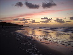 Vlieland, beach at dusk
 Aerial view of southern part of Vlieland from Texel


References
- "Burgemeester en wethouders" [Mayor and aldermen] (in Dutch). Gemeente Vlieland. Archived from the original on 7 October 2013. Retrieved 5 October 2013.
- "Kerncijfers wijken en buurten 2020" [Key figures for neighbourhoods 2020]. StatLine (in Dutch). CBS. 24 July 2020. Retrieved 19 September 2020.
- "Postcodetool for 8899AE". Actueel Hoogtebestand Nederland (in Dutch). Het Waterschapshuis. Retrieved 5 October 2013.
- "Bevolkingsontwikkeling; regio per maand" [Population growth; regions per month]. CBS Statline (in Dutch). CBS. 1 January 2019. Retrieved 1 January 2019.
- "Duinen Vlieland". Ramsar Sites Information Service. Retrieved 25 April 2018.
- J.T. Bremer, De genese van de Kop van Noord-Holland en het westelijk Waddengebied, in Van Groningen tot Zeeland: geschiedenis van het cultuurhistorisch onderzoek naar het kustlandschap, Uitgeverij Verloren, 2010, p. 1100
- Friesland zoals het was, September 1942 Archived 2015-12-24 at the Wayback Machine, Tresoar
- Harrie Scholtmeijer, Veranderingen in het Vlielands at the Meertens Institute website
- "TIME TABLE". www.rederij-doeksen.nl. Archived from the original on 16 July 2016. Retrieved 18 December 2015.
- "Texel-Vlieland v.v." Archived from the original on 11 November 2017. Retrieved 18 December 2015.
- "Gemeenteraad 21 maart 2018". Verkiezingsuitslagen (in Dutch). Retrieved 18 July 2018.
- "College". Vlieland (in Dutch). Retrieved 30 December 2017.
- "Installatie Tineke Schokker als burgemeester van Vlieland". Vlieland (in Dutch). Retrieved 30 December 2017.
- Into The Great Wide Open Facebook - Into The Great Wide Open
External links
Places adjacent to Vlieland | ||||||||||||||||
|---|---|---|---|---|---|---|---|---|---|---|---|---|---|---|---|---|
| ||||||||||||||||
Municipalities of Friesland | ||
|---|---|---|
 | ||
| ||
| West Frisian Islands (Netherlands) |
|  | |||||
|---|---|---|---|---|---|---|---|
| East Frisian Islands (Germany) |
| ||||||
| Heligoland Bight (Germany) |
| ||||||
| North Frisian Islands (Germany) |
| ||||||
| Danish Wadden Sea Islands (Denmark) |
| ||||||
На других языках
[de] Vlieland
Die zu den Niederlanden gehörende Insel Vlieland (fries.: Flylân) ist eine der fünf bewohnten Westfriesischen Inseln. Sie hatte am 1. Januar 2022 eine Einwohnerzahl von 1196.- [en] Vlieland
[es] Vlieland
Vlieland (Flylân en frisón) es una de las islas Frisias, situada entre Texel y Terschelling. El mar del Norte queda al noroeste y el mar de Frisia al sureste. La isla constituye además un único municipio homónimo de la provincia de Frisia en los Países Bajos. En 2013 tenía una población de 1.109 habitantes ocupando una superficie de 315,80 km², de los que 279,67 km² corresponden a la superficie ocupada por el agua por solo 36,13 km² de tierra, con una densidad de población de 31 h/km².[fr] Vlieland
Vlieland est une île et une commune néerlandaise de Frise.[it] Vlieland
Vlieland .mw-parser-output .audiolink a{background:url("//upload.wikimedia.org/wikipedia/commons/thumb/8/8a/Loudspeaker.svg/11px-Loudspeaker.svg.png")center left no-repeat!important;padding-left:16px!important;padding-right:0!important}ascolta[?·info] è un'isola del mare del Nord nel gruppo delle isole Frisone Occidentali ed una municipalità dei Paesi Bassi di 1.157 abitanti situata nella provincia della Frisia.[ru] Влиланд
Влиланд (нидерл. Vlieland) — остров и община в нидерландской провинции Фрисландия, один из Фризских островов. Население острова — 1145 человек (по состоянию на 2008). На острове есть только один населённый пункт, посёлок Ост-Влиланд (нидерл. Oost-Vlieland). Площадь общины (вместе с подчинённой ей акваторией) — 315,79 км², площадь собственно острова — 40,26 км².Другой контент может иметь иную лицензию. Перед использованием материалов сайта WikiSort.org внимательно изучите правила лицензирования конкретных элементов наполнения сайта.
WikiSort.org - проект по пересортировке и дополнению контента Википедии