geo.wikisort.org - Island
Juist (German pronunciation: [ˈjyːst]) (Low German: Juist) is an island and municipality in the district of Aurich in Lower Saxony in Germany. The island is one of seven East Frisian Islands at the edge of the Lower Saxon Wadden Sea in the southern North Sea. It is located between Borkum Island (west), Memmert Island (southwest) and Norderney (east). The island is 17 km (11 mi) long and from 500 metres (1,600 ft) to 1 kilometre (0.62 mi) wide, depending on the tide levels. There are two villages on the island: the main village Juist, and Loog. The island is separated from Norderney by the Norderneyer Seegatt.
Juist | |
|---|---|
Municipality | |
 Aerial view of Juist from the east | |
 Flag  Coat of arms | |
Location of Juist within Aurich district 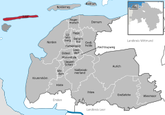 | |
 Juist  Juist | |
| Coordinates: 53°40′43″N 6°59′51″E | |
| Country | Germany |
| State | Lower Saxony |
| District | Aurich |
| Subdivisions | 2 districts |
| Government | |
| • Mayor (2016–26) | Tjark Axel Goerges[1] |
| Area | |
| • Total | 16.43 km2 (6.34 sq mi) |
| Elevation | 3 m (10 ft) |
| Population (2020-12-31)[2] | |
| • Total | 1,534 |
| • Density | 93/km2 (240/sq mi) |
| Time zone | UTC+01:00 (CET) |
| • Summer (DST) | UTC+02:00 (CEST) |
| Postal codes | 26557–26571 |
| Dialling codes | 04935 |
| Vehicle registration | AUR |
| Website | www |
Overview and geography

The tallest buildings on Juist that can be seen from the North Sea are the water tower and an old hotel. There is a lighthouse on the island, but it is not in use. At the western end of the island is the Billreef, a large sandbank where birds such as dunlins, grey plovers and knots rest during their migration. In the western part of the island the beach and the dunes are eroded by the sea. The edge of the dunes moves about five metres south each winter. On the western third of the island is Lake Hammersee, a freshwater lake.
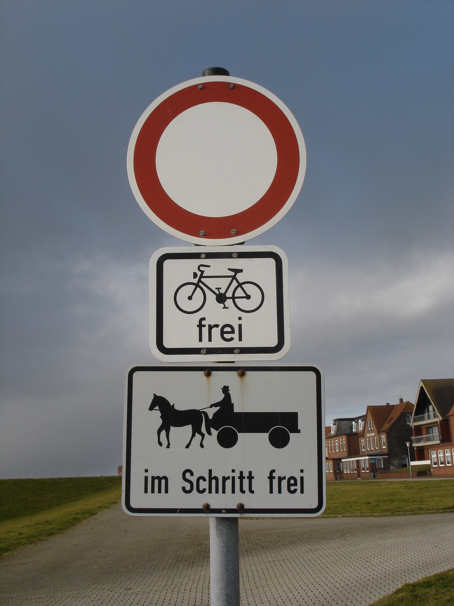
Juist is accessible by plane or daily ferry. FLN Frisia Luftverkehr operates planes between Norden and Juist. Most motor vehicles are prohibited on the island, with only the fire department, the German Red Cross and doctors allowed to use them.[3] Island tractors require a special license, while most other transport is done by bike or horse-drawn carriage. It was reported by the Reuters news agency, 24 September 2014, that an unmanned "parcelcopter" will commence delivery of urgent drugs and supplies to the island by DHL.[4] It will be the first time an unmanned aircraft had been authorised to deliver goods in Europe and the first time that automated drones have been used to deliver medicines anywhere in the world. The flight at an altitude of 50 m and at a speed of up to 18 m/s will be automated but monitored in Norddeich.
Economy
Tourism is the main source of income for Juist's economy. Almost all the buildings on the island feature guestrooms, with several hotels and a youth hostel also on the island. There is an island partnership between Juist and Hiddensee in the Baltic Sea.
History
In the 17th and 18th century Juist was cut in two parts by several storm tides (see St. Peter's Flood). Around year 1770 people started to close the 2 km wide burst at the southern side by a dune dike. As recently as 1928 the northern side was repaired. By that time, the water in Lake Hammersee had turned from saltwater to freshwater. On September 9, 2001 Juist citizens voted for their mayor directly for the first time, with Karl-Josef Wederhake winning the election. He was re-elected in September 2006.
Notable people
- Curt Bruns (1915–1945) war criminal who was executed for murdering two Jewish POWs. He was the first Nazi war criminal to be executed in Allied-occupied Germany.
- Martin Luserke (1880–1968) founded Stiftung Schule am Meer in 1924 and Schule am Meer in 1925 on Juist.
- Ma Anand Sheela (1949-) lived in Juist after leaving Rajneeshpuram in Oregon.[5]
References
- "Dr. Tjark Goerges bleibt zwei Amtperioden Juister Bürgermeister". juistnews.de. 12 March 2017.
- Landesamt für Statistik Niedersachsen, LSN-Online Regionaldatenbank, Tabelle A100001G: Fortschreibung des Bevölkerungsstandes, Stand 31. Dezember 2020.
- "100 horses, but hardly any cars Juist is car-free". juist.de. City of Juist. Retrieved July 20, 2021.
- Reuters Staff (September 24, 2014). "Drone delivery: DHL 'parcelcopter' flies to German isle". Reuters. Reuters. Retrieved July 20, 2021.
- "»Sheela, zeige dich dem Volke«". Der Spiegel (in German). 29 September 1985. Retrieved 17 September 2022.
| West Frisian Islands (Netherlands) |
|  | |||||
|---|---|---|---|---|---|---|---|
| East Frisian Islands (Germany) |
| ||||||
| Heligoland Bight (Germany) |
| ||||||
| North Frisian Islands (Germany) |
| ||||||
| Danish Wadden Sea Islands (Denmark) |
| ||||||
Towns and municipalities in Aurich (district) | ||
|---|---|---|
 | ||
Authority control | |
|---|---|
| General |
|
| National libraries | |
На других языках
[de] Juist
Juist (dt. [.mw-parser-output .IPA a{text-decoration:none}jyːst], niederl. [jœy̑st], fries. [jyːst]) ist eine der ostfriesischen Inseln im niedersächsischen Wattenmeer der Nordsee und liegt zwischen Borkum im Westen und Norderney im Osten. Die Insel hat eine Länge von 17 Kilometern und ist damit die längste der ostfriesischen Inseln. Die maximale Breite beträgt 900 Meter, die minimale 500 Meter. Auf der Insel befindet sich die gleichnamige Einheitsgemeinde Juist, sie gehört zum Landkreis Aurich in Niedersachsen und hat 1515 Einwohner.[2] Auf der Insel gibt es zwei Ortsteile: den in Westdorf und Ostdorf unterteilten Hauptort sowie Loog.- [en] Juist
[es] Juist
Juist es una isla Frisia alemana situada entre Norderney (al este) y Borkum (al oeste) y al norte del estuario del Ems. Es una isla alargada (17 km de largo por 500 m de ancho) con 16,43km² de superficie. Sus 1.801 habitantes (2003) se encuentran repartidos en dos pueblos: Juist (también llamado Dorf) y Loog. Administrativamente constituye un municipio, que pertenece al estado de la Baja Sajonia.[fr] Juist
Juist est une île allemande d'environ 16 km2 et la deuxième des Îles de la Frise-Orientale vu de l'ouest entre Borkum et Norderney. Elle appartient comme commune à l'arrondissement d'Aurich au Land de Basse-Saxe.[it] Juist
Juist (pron. [jyːst]; 16,43 km²; 1.700 ab. circa) è una delle sette isole abitate dell'arcipelago delle Frisone Orientali (Ostfriesische Inseln), gruppo di isole tedesche sul Mare del Nord, appartenenti al land Bassa Sassonia (Niedersachsen, Germania nord-occidentale). Dal punto di vista amministrativo, l'isola è un comune del circondario di Aurich (targa: AUR), a cui appartengono anche le isole di Norderney e Baltrum.[ru] Юст (остров)
Юст[3][4] (Юист (устар.)[5]) — остров в Германии, входящий в состав Восточно-Фризских островов. В административном плане имеет статус посёлка в земле Нижняя Саксония.Другой контент может иметь иную лицензию. Перед использованием материалов сайта WikiSort.org внимательно изучите правила лицензирования конкретных элементов наполнения сайта.
WikiSort.org - проект по пересортировке и дополнению контента Википедии