geo.wikisort.org - Island
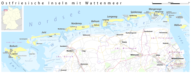
The East Frisian Islands (German: Ostfriesische Inseln, West Frisian: Eastfryske eilannen, Saterland Frisian: Aastefräiske Ailounds) are a chain of islands in the North Sea, off the coast of East Frisia in Lower Saxony, Germany. The islands extend for some 90 kilometres (56 mi) from west to east between the mouths of the Ems and Jade / Weser rivers and lie about 3.5 to 10 km offshore. Between the islands and the mainland are extensive mudflats, known locally as Watten, which form part of the Wadden Sea. In front of the islands are Germany's territorial waters, which occupy a much larger area than the islands themselves. The islands, the surrounding mudflats and the territorial waters (The Küstenmeer vor den ostfriesischen Inseln nature reserve) form a close ecological relationship. The island group makes up about 5% of the Lower Saxony Wadden Sea National Park.
Native name: Ostfriesische Inseln | |
|---|---|
 | |
 | |
| Geography | |
| Location | Wadden Sea |
| Total islands | 12 |
| Major islands | Borkum, Norderney |
| Administration | |
Germany | |
| State | Lower Saxony |
| Districts | Leer Aurich Wittmund Friesland |
| Demographics | |
| Ethnic groups | Germans, Frisians |
The largest island by surface area is Borkum, located at the western end of the chain; the other six inhabited islands are from west to east: Juist, Norderney with the largest town in the islands, Baltrum, Langeoog, Spiekeroog and Wangerooge. There are also four other small, uninhabited islands: Lütje Hörn east of Borkum, Memmert and Kachelotplate southwest of Juist, Minsener Oog, a dredged island southeast of Wangerooge, and Mellum at the eastern end of the island chain which, following the boundary revision by the Federal Office for Nature Conservation, no longer belongs to the East Frisian Islands, but to the mudflats of the Elbe-Weser Triangle (Watten im Elbe-Weser-Dreieck).
Overview of the islands and sand flats
The following table contains basic information about the islands and sand flats (Sandplaten). The uninhabited and unparished sand flats are highlighted in yellow.
| Coat of arms | Island/Sand flat | Municipality | District | Area in km² (2004[1]/05[2]) |
Distance to the mainland in km (2004)[1] |
Population as at: 31 December 2008 |
Population density per km² | |||||||||||||||||||||||||||||||||||||||||||||||||||||||||||||||||||||||||||||||||||||||||||
|---|---|---|---|---|---|---|---|---|---|---|---|---|---|---|---|---|---|---|---|---|---|---|---|---|---|---|---|---|---|---|---|---|---|---|---|---|---|---|---|---|---|---|---|---|---|---|---|---|---|---|---|---|---|---|---|---|---|---|---|---|---|---|---|---|---|---|---|---|---|---|---|---|---|---|---|---|---|---|---|---|---|---|---|---|---|---|---|---|---|---|---|---|---|---|---|---|---|---|
 | Borkum | Town of Borkum | Leer | 30.74[2] | 10.5 | 5,186 | 169 | |||||||||||||||||||||||||||||||||||||||||||||||||||||||||||||||||||||||||||||||||||||||||||
| Kachelotplate | not municipalised | no data | uninhabited | − | ||||||||||||||||||||||||||||||||||||||||||||||||||||||||||||||||||||||||||||||||||||||||||||||
| Lütje Hörn | Island of Lütje Hörn¹ | Leer | 0.1[1] | 12.5 | uninhabited | − | ||||||||||||||||||||||||||||||||||||||||||||||||||||||||||||||||||||||||||||||||||||||||||||
| Memmert | North Sea island of Memmert¹ | Aurich | 4.3[1] | 13 | uninhabited | − | ||||||||||||||||||||||||||||||||||||||||||||||||||||||||||||||||||||||||||||||||||||||||||||
 | Juist | Juist | Aurich | 16.43[2] | 8 | 1,696 | 103 | |||||||||||||||||||||||||||||||||||||||||||||||||||||||||||||||||||||||||||||||||||||||||||
 | Norderney | Town of Norderney | Aurich | 26.29[2] | 3 | 5,810 | 221 | |||||||||||||||||||||||||||||||||||||||||||||||||||||||||||||||||||||||||||||||||||||||||||
 | Baltrum | Baltrum | Aurich | 6.5[2] | 4.5 | 488 | 75 | |||||||||||||||||||||||||||||||||||||||||||||||||||||||||||||||||||||||||||||||||||||||||||
 | Langeoog | Langeoog | Wittmund | 19.67[2] | 5 | 1,953 | 99 | |||||||||||||||||||||||||||||||||||||||||||||||||||||||||||||||||||||||||||||||||||||||||||
 | Spiekeroog | Spiekeroog | Wittmund | 18.25[2] | 6.5 | 781 | 43 | |||||||||||||||||||||||||||||||||||||||||||||||||||||||||||||||||||||||||||||||||||||||||||
 | Wangerooge | Wangerooge | Friesland | 7.94[2] | 6,5 | 923 | 116 | |||||||||||||||||||||||||||||||||||||||||||||||||||||||||||||||||||||||||||||||||||||||||||
| Minsener Oog artificially dredged | Butjadingen² | Wesermarsch | 2.2[1] | 3.5 | uninhabited | − | ||||||||||||||||||||||||||||||||||||||||||||||||||||||||||||||||||||||||||||||||||||||||||||
| Mellum³ | Butjadingen² | Wesermarsch | 4.9[1] | 6 | uninhabited | − | ||||||||||||||||||||||||||||||||||||||||||||||||||||||||||||||||||||||||||||||||||||||||||||
| East Frisian Islands | 134.35[2] | − | 16,837 | 129 | ||||||||||||||||||||||||||||||||||||||||||||||||||||||||||||||||||||||||||||||||||||||||||||||
| ¹ unparished area ² former parish of Langwarden, which was incorporated in 1974 into Butjadingen (today the Gemarkung of Langwarden) ³ east of the outer Jade, after the boundary revision by the Federal Agency for Nature Conservation no longer part of the East Frisian Islands, but belongs to the mudflats in the Elbe-Weser Triangle Watten im Elbe-Weser-Dreieck.[3] | ||||||||||||||||||||||||||||||||||||||||||||||||||||||||||||||||||||||||||||||||||||||||||||||||||
Norderney is the remaining part of Buise, which was almost entirely engulfed by the sea in the 17th century. Lütje Hörn east of Borkum is in constant danger of being washed away. In 2003 the German Coastal Defence (NLWK) announced that the sandbank Kachelotplate can now be called an island too, because it is no longer regularly flooded by high tide. However, it is not larger than 2 km² and will remain unsettled. Kachelotplate is located north of the mouth of the Ems river.
Most of the islands do not allow cars. The exceptions are Borkum and Norderney, which are also the most crowded islands. There are no bridges connecting the mainland with the islands. Each island is accessible by ferry.
Borkum and Norderney, the Nazi labour camps on Alderney, were named after the islands.
The islands and the surrounding sea are part of the Lower Saxony Wadden Sea National Park.
Effects of storms and currents

Even though today they are established islands, some of them continue to be in motion. On the East Frisian island of Juist for example, since the year 1650 there are five different proven sites for the church, as the spot for rebuilding the church had to keep pace with the ever-moving island. At times, Juist even consisted of two islands, which eventually grew back together. The neighbouring island of Wangerooge in the last 300 years has moved a distance equivalent to its own length to the east, its church tower, destroyed at the outbreak of World War I apparently moving from east to west.[4]
In this process, land is slowly eroded on the western coasts, while sediments are deposited on the eastern coasts. As a result, western coasts are increasingly protected by human action. The canals between the islands serve as passages for the tides, so that in these places the scouring action of current prevents the islands gradually joining one to another.
In popular culture
A German invasion fleet masses in the Frisian Islands in the pre-World War I invasion thriller Riddle of the Sands.
German students memorize the names of the seven inhabited islands by using a mnemonic device:
Welcher Seemann liegt bei Nanni im Bett?
At a first glance, the question for Nanni's company for the night does not seem to make a lot of sense. In the German original, however, the very first letter of every individual word represents the first letter of the name of the island geographically occupying the same position in the chain of islands (in east-to-west-direction) that the respective word occupies within the chain of words, i.e. the sentence.
The device: Welcher — Seemann — liegt — bei — Nanni — im — Bett?
In English: Which — seaman — lies — by — Nanni — in [the] — bed? (Here, the word "bei", literally "by", means "next to", "with")
Representing Wangerooge, Spiekeroog, Langeoog, Baltrum, Norderney, Juist '*' and Borkum, in order.
'*' The old German alphabet at the time of the creation of the mnemonic did not yet differ between "i" and "j"
See also
- Frisia
- Frisian languages
- Frisians
- East Frisian Low Saxon
- List of islands of Germany
- List of ferry boats of the East Frisian Islands
References
- Rolf Niedringhaus; Volker Haeseler; Peter Janiesch (2008), Die Flora und Fauna der East Frisian Islands – Einführung in das Projekt "Biodiversität im Nationalpark Niedersächsisches Wattenmeer" (in German), vol. 11, Schriftenreihe Nationalpark Niedersächsisches Wattenmeer
- "NLS-Online Tabelle Z0010001 Bodenfläche nach Art der geplanten Nutzung". Landesbetrieb für Statistik und Kommunikationstechnologie Niedersachsen (LSKN). 2005-01-01. Retrieved 2009-04-23.
- "Watten im Elbe-Weser-Dreieck, Jadebusen". Bundesamt für Naturschutz. Archived from the original on 2011-09-16. Retrieved 2009-12-02.
- "Germany's High Seas Fleet in the World War". War Times Journal. Retrieved 2007-09-30.
External links
| Wikivoyage has a travel guide for East Frisian Islands. |
| West Frisian Islands (Netherlands) |
|  | |||||
|---|---|---|---|---|---|---|---|
| East Frisian Islands (Germany) |
| ||||||
| Heligoland Bight (Germany) |
| ||||||
| North Frisian Islands (Germany) |
| ||||||
| Danish Wadden Sea Islands (Denmark) |
| ||||||
Authority control | |
|---|---|
| General |
|
| National libraries | |
На других языках
[de] Ostfriesische Inseln
Die Ostfriesischen Inseln sind eine Gruppe deutscher Nordseeinseln. Sie liegen aufgereiht vor der niedersächsischen Festlandsküste, entlang der Ostfriesischen Halbinsel. Die Inselgruppe erstreckt sich über rund 90 Kilometer Länge von West nach Ost zwischen den Mündungen von Ems und Jade beziehungsweise der Weser, und zwischen 3,5 und 10 Kilometer dem Festland vorgelagert. Zwischen den Inseln und dem Festland befinden sich ausgedehnte Wattbereiche, sie nehmen eine größere Fläche ein als die Inseln selbst. Den Inseln vorgelagert liegt das Küstenmeer. Die Inseln, das umgebende Watt sowie das Küstenmeer (Naturschutzgebiet „Küstenmeer vor den ostfriesischen Inseln“) stehen in einer engen ökologischen Beziehung. Die Inselgruppe ist Teil des größten Wattenmeeres in der Nordsee und umfasst etwa fünf Prozent des Nationalparks Niedersächsisches Wattenmeer. Naturräumlich stellen die Ostfriesischen Inseln die Haupteinheiten 613 dar.[1]- [en] East Frisian Islands
[es] Islas Frisias orientales
Las islas Frisias orientales (en alemán, Ostfriesische Inseln) constituyen una cadena de islas ubicadas en el mar del Norte, frente a las costas del estado federado de Baja Sajonia, Alemania, de cuyo término estatal forman parte.[1][2][fr] Îles de la Frise-Orientale
Les îles de la Frise-Orientale (all.:Ostfriesische Inseln) sont un archipel côtier allemand de la mer du Nord qui fait partie du chapelet des îles de la Frise. L'archipel est situé devant la côte de la Basse-Saxe entre les embouchures de l'Ems et de la Weser, l'espace marin entre le continent et les îles constitue la mer des Wadden.[it] Isole Frisone Orientali
Le isole Frisone Orientali sono un gruppo di isole del mare del Nord situate a circa 5–10 km dalla costa della Bassa Sassonia in Germania in un'area lunga circa 90 km compresa fra gli estuari dei fiumi Jade ed Ems. Le isole maggiori, tutte abitate sono 7, da ovest a est: Borkum, Juist, Norderney, Baltrum, Langeoog, Spiekeroog e Wangerooge. Vi sono poi alcuni isolotti disabitati, alcuni dei quali hanno origine artificiale, ad esempio l'isola di Minsener Oog fu costruita all'inizio degli anni venti per riparare il corridoio navigabile verso Wilhelmshaven. Il banco di sabbia di Kachelotplate tra Borkum e Juist non viene più inondato dalle maree e dal 2004 è considerato un'isola. Altre isole disabitate sono Memmert a sud di Juist, Mellum ad est di Wangerooge e la piccola isola di Lütjehörn, ad est di Borkum che rischia costantemente di essere sommersa.[ru] Восточно-Фризские острова
Восточно-Фризские острова (нем. Ostfriesische Inseln) — цепь островов в Северном море у побережья Восточной Фризии в Нижней Саксонии. Острова вместе с окружающим их морем являются частью (примерно 5 %) Национального парка Шлезвиг-Гольштейнские ватты. Площадь островов составляет примерно 134,35 км², население на 31 декабря 2008 года 16 837 человек.Другой контент может иметь иную лицензию. Перед использованием материалов сайта WikiSort.org внимательно изучите правила лицензирования конкретных элементов наполнения сайта.
WikiSort.org - проект по пересортировке и дополнению контента Википедии