geo.wikisort.org - River
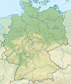
The Weser ([ˈveːzɐ]) is a river of Lower Saxony in north-west Germany. It begins at Hannoversch Münden through the confluence of the Werra and Fulda. It passes through the Hanseatic city of Bremen. Its mouth is 50 km (31 mi) further north against the ports of Bremerhaven and Nordenham. The latter is on the Butjadingen Peninsula. It then merges into the North Sea via two highly saline, estuarine mouths.
This article needs additional citations for verification. (March 2021) |
| Weser Werser (Low German) | |
|---|---|
 The Weser near Bad Oeynhausen | |
 Watershed of the Weser | |
 European context: mouth within Germany. | |
| Etymology | *waisōn, Proto-Germanic, meaning "flow" or "ooze" |
| Location | |
| Country | Germany |
| States |
|
| Cities | |
| Physical characteristics | |
| Source | |
| • location | Confluence of the Fulda and Werra Rivers in Hann. Münden |
| • coordinates | 51°25′17″N 9°38′53″E |
| • elevation | 116 m (381 ft) |
| Mouth | Wadden Sea of the North Sea |
• location | Between Bremerhaven and Nordenham |
• coordinates | 53°32′8″N 8°33′56″E |
• elevation | 0 m (0 ft) |
| Length | 452 km (281 mi) [744 km (462 mi) if combined with the Werra] |
| Basin size | 46,306 km2 (17,879 sq mi) |
| Discharge | |
| • average | 327 m3/s (11,500 cu ft/s) |
| Basin features | |
| River system | Weser basin |
| Tributaries | |
| • left | Diemel, Emmer, Werre, Große Aue, Hunte |
| • right | Aller, Lesum |

It connects to the canal network running east-west across the North German Plain.
The river, when combined with the Werra (a dialectal form of "Weser"), is 744 km (462 mi) long and thus, the longest river entirely situated within Germany (the Main, however, is the longest if the Weser and Werra are not combined). The Weser itself is 452 km (281 mi) long. The Werra rises in Thuringia, the German state south of the main projection (tongue) of Lower Saxony.
Etymology
"Weser" and "Werra" are the same words in different dialects. The difference reflects the old linguistic border between Central and Low German, passing through Hannoversch Münden.
The name likely derives from the Old Germanic *waisōn "flow, ooze".[1] It is cognate with the Wear in England and Vistula (Polish Wisła, German Weichsel) in Poland, all of which are derived from the Proto-Indo-European root *weys- "to flow", which also gives rise to Old English/Old Frisian wāse "mud, ooze", Old Norse veisa "slime, stagnant pool", Dutch waas "haze; soggy land" (see Waasland), Old Saxon waso "wet ground, mire", Old High German wasal "rain" and French vase "mud, sludge".
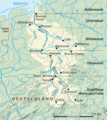
Course
The Weser starts at the confluence of the Fulda and the Werra. It then runs down to the Porta Westfalica between two high hill ranges, the Wiehengebirge, west and the Weserbergland in the east.
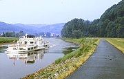
Between Minden and the North Sea, humans have largely canalised the river up to a limit of 1,200-ton ships. Eight hydroelectric dams stand at the ends of adjacent weirstreams that make up the river. The navigation is linked west to the Dortmund–Ems Canal via the Coastal Canal. It is linked east at Bremerhaven to the Elbe.
A large reservoir, the Edersee, on the Eder, the main tributary of the Fulda, is used to allow enough water depth for shipping year-round. The dam, built in 1914, was bombed and severely damaged by British aircraft in May 1943, causing great destruction and about 70 deaths downstream. It was rebuilt within four months. The reservoir is a major summer resort area. Turbines driven by its sluices provide electricity.

 "Upper" Weser, in reality the central section between the upper courses Werra and Fulda, and the lowland section
 Mittelland Canal/ River Weser Lock in Minden taken in 1977
 View north of the River Weser and the road bridge at Minden
 Southern view of the River Weser from the road bridge at Minden in 1977


The Weser enters the North Sea in the southernmost part of the German Bight. In the sea it splits into two arms – the riverbed at the end of the last ice age. These sea arms are called Alte Weser (old Weser) and Neue Weser (new Weser). They are the waterways for ships heading for the ports of Bremerhaven, Nordenham, and Bremen. The Alte Weser Lighthouse marks the northernmost point of the Weser. This replaced the Roter Sand Lighthouse in 1964.
Tributaries
The largest tributary of the Weser is the Aller, which joins south of Bremen. Tributaries of the Weser and the Werra (from source to mouth) are:
Modes of the list:
- Listed upstream, but sides seen with the flow
- Distances ("km …") from the hydrographical limit towards the sea
- "II", "III"and "IV" mark distances of secondary/tertiary tributaries from the confluence with the Weser etc.
- After the names, lengths and basin sizes are given.
- Lengths with longer affluents are given behind the slash, lengths including an upper course with another name with "or"

List:
- km 19, right: Geeste (in Bremerhaven), 42.5 km, 338 km2
- km 33, right: Lune, 43 km, 383 km2
- km 35.9, right: Drepte, 37.6 km, 101 km2
- km 52.8, left: Hunte, 189 km, 2.785 km2
- II: km 125.7: Lake Dümmer
- km 67.6, right: Lesum, 9.9 or 131.5, 2,188 km2
- km 72.5, left: Ochtum, 25.6 or 45 km, 917 km2
- II: km 25.6: left Hache, 33 km, 118 km2
- km 125.6, right: Aller, 260 km, 15,744 km2
- km 184.6, right: Steinhuder Meerbach
- ↑ km II: 29 lake Steinhuder Meer
- km 188.7, left: Große Aue, 84.5 km, 1,522 km2
- km 261.3, left: Werre, 71.9 km, 1485 km2
- km 287.7, left: Exter, 26.1 km, 109 km2
- km 323.3, left: Emmer, 61.8 km, 535 km2
- km 387.5, left: Nethe, 50.4 km, 460 km2
- km 406.5, left: Diemel, 110.5 km, 1,762 km2
- km 451.5, left: Fulda, 220.4 km, 6.947 km2
- ↑ main stream above km 451.5: Werra, 299.6 km, 5.497 km2
- km 566.5, right: Hörsel, 55.2 or 64.3, 784 km2
- km 9.8, right: Nesse, 54.5 km, 426 km2
- km 513.1, left: Ulster, 57.2 km, 421 km2
- km 604.4, right: Schleuse, 34.2 km, 283 km2
Notable towns
Main towns along the Weser are (from the head of the river to its mouth): Hann. Münden, Beverungen, Höxter, Holzminden, Bodenwerder, Hamelin, Hessisch Oldendorf, Rinteln, Vlotho, Bad Oeynhausen, Porta Westfalica, Minden, Petershagen, Nienburg, Achim, Bremen, Brake, Nordenham, Bremerhaven.
Popular culture
The river features in the legend and folk tale the Pied Piper of Hamelin.
References
- Orel, Vladimir (2003). A Handbook of Germanic Etymology. Netherlands: Koninklijke Brill NV. p. 441. ISBN 9789004128750.
Etymology
- Dieter Berger: Geographische Namen in Deutschland. Duden-Verlag, Mannheim 1999.
- Hans Krahe: Sprache und Vorzeit. Quelle & Meyer, Heidelberg 1954. (Zur alteuropäischen Hydronomie.)
- Julius Pokorny: Indogermanisches etymologisches Wörterbuch. Francke, Bern 1959.
Geology
- Karsten Meinke: Die Entwicklung der Weser im Nordwestdeutschen Flachland während des jüngeren Pleistozäns. Diss., Göttingen 1992. Mit Bodenprofilen der Weserstädte.
- Ludger Feldmann und Klaus-Dieter Meyer (Hrsg.): Quartär in Niedersachsen. Exkursionsführer zur Jubiläums-Hauptversammlung der Deutschen Quartärvereinigung in Hannover. DEUQUA-Exkursionsführer, Hannover 1998, page 89ff.
- Hans Heinrich Seedorf und Hans-Heinrich Meyer: Landeskunde Niedersachsen. Natur und Kulturgeschichte eines Bundeslandes. Volume 1: Historische Grundlagen und naturräumliche Ausstattung. Wachtholz, Neumünster 1992, page 105ff.
- Ludger Feldmann: Das Quartär zwischen Harz und Allertal mit einem Beitrag zur Landschaftsgeschichte im Tertiär. Papierflieger, Clausthal-Zellerfeld 2002, page 133ff and others.
Archaeology
- Bremer Archäologische Blätter, Beiheft 2/2000 zur gleichnamigen Ausstellung im Focke-Museum: Siedler, Söldner und Piraten, Chauken und Sachsen im Bremer Raum, Der Landesarchäologe Bremen, ISSN 0068-0907.
- Bremer Archäologische Blätter, Beiheft 3/2004 zur gleichnamigen Ausstellung im Focke-Museum: Gefundene Vergangenheit, Archäologie des Mittelalters in Bremen, Der Landesarchäologe Bremen, ISBN 3-7749-3233-6. (wg.Geschichte des Weserarms Balge)
History
- Georg Bessell: Geschichte Bremerhavens. Morisse, Bremerhaven 1927, 1989.
- Heinz Conradis: Der Kampf um die Weservertiefung in alter Zeit. In: Bremisches Jahrbuch. Bremen 41.1944.
- J. W. A. Hunichs: Practische Anleitung zum Deich-, Siel- und Schlengenbau. Erster Theil, von den Sielen. Bremen 1770.
- Die Kanalisierung der Mittelweser. Published by the Mittelweser AG, Carl Schünemann Verlag, Bremen 1960.
- Kuratorium für Forschung im Küsteningenieurswesen: Die Küste. In: Archiv für Forschung und Technik an der Nord- und Ostsee. Boyens, Heide 51.1991. ISSN 0452-7739
Description
- Karl Löbe: Das Weserbuch. Niemeyer, Hameln 1968.
- Nils Aschenbeck, Wolf Dietmar Stock: Eine Flussfahrt von der Aller bis zur Nordsee. Atelier im Bauernhaus, Fischerhude 1998. ISBN 3-88132-350-3.
Authority control | |
|---|---|
| General |
|
| National libraries | |
| Other | |
На других языках
[de] Weser
Die Weser (niederdeutsch Werser oder Wersern; lateinisch Bisurgis, Visurgis; althochdeutsch Wisera, Wisura;[6] weserfriesisch Wißuhr[7]) ist ein Strom, der in nördlicher Richtung die Mittelgebirgsschwelle und das norddeutsche Tiefland durchfließt. Seinen Namen trägt er ab Hann. Münden, wo sich seine beiden großen Quellflüsse, Werra und Fulda, vereinigen.- [en] Weser
[es] Weser
El Weser es un río del noroeste de Alemania. Formado en Hannoversch Münden por la confluencia del Fulda y el Werra, fluye en dirección norte por los estados de Hesse, Baja Sajonia, Renania del Norte-Westfalia y Bremen durante 452 km —el sistema Weser-Werra llega a los 744 km— hasta desembocar en el mar del Norte. Es el río más largo enteramente en el país.[it] Weser
Il Weser (pronuncia tedesca /'ve:zɐ/, Visurgis in latino,[1] die Weser[2] in tedesco) è un importante fiume della Germania nord-occidentale che nasce dall'unione presso Hann. Münden, in Bassa Sassonia, dei fiumi Fulda, passante per l'omonima città dell'Assia, e Werra. La coppia Weser/Fulda è lunga in totale 650 km, mentre quella Weser/Werra 750. Il Weser è il più lungo fiume interamente compreso nel territorio tedesco.[ru] Везер
Ве́зер (нем. Weser [ˈveːzɐ], н.-нем. Werser) — река в Германии, текущая в северном направлении, пересекая Немецкое среднегорье и Северо-Германскую низменность. Своё название носит начиная от города Мюнден, где соединяются оба её истока Верра и Фульда. Под Бремерхафеном Везер впадает в Северное море. По всей своей длине Везер является Федеральным водным путём[1] и протекает через федеральные земли Гессен, Северный Рейн-Вестфалия, Нижняя Саксония и Бремен. К её бассейну относятся также речки Тюрингии и Саксонии-Анхальт. Длина реки — 451 км.[2]Другой контент может иметь иную лицензию. Перед использованием материалов сайта WikiSort.org внимательно изучите правила лицензирования конкретных элементов наполнения сайта.
WikiSort.org - проект по пересортировке и дополнению контента Википедии