geo.wikisort.org - River
Hunte is a 189-kilometre (117 mi) long river in north-western Germany (Lower Saxony), a left tributary of the Weser.
| Hunte | |
|---|---|
 The Hunte in the Wildeshausen Geest | |
 | |
| Location | |
| Country | Germany |
| State | Lower Saxony |
| Physical characteristics | |
| Source | |
| • location | Wiehengebirge |
| • coordinates | 52°15′36″N 8°20′33″E |
| • elevation | 185 m above sea level (NN) |
| Mouth | |
• location | Elsfleth |
• coordinates | 53°15′10″N 8°28′44″E |
• elevation | 0 m (0 ft) |
| Length | 189 km (117 mi) |
| Basin size | 2,635 km2 (1,017 sq mi) [1] |
| Basin features | |
| Progression | Weser→ North Sea |
| Landmarks |
|
| Population | 432000[2] |
| Tributaries | |
| • left | Haaren, Lethe |
| • right | Wagenfelder Aue, Ollen |
| Waterbodies | Lakes: Dümmer |
| Navigable | between Oldenburg and Elsfleth for Europa Ships and coasters; as far as the Coastal Canal (Küstenkanal) for ships up to 1000 Brutto Register Tonnage |
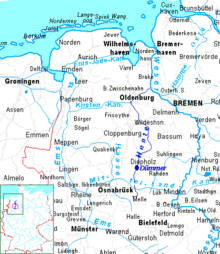
The Hunte rises in the Wiehen Hills. In the North German Plain it flows through lake Dümmer. It flows generally northwards through the towns Bad Essen, Diepholz, Wildeshausen and Oldenburg. It flows into the Weser in Elsfleth. The part between Oldenburg and the Weser is navigable for coastal cargo ships. The Küsten Canal, suitable for inland navigation only, links the Hunte in Oldenburg to river Ems near Papenburg.
Catchment
The catchment of the Hunte is relatively narrow (its maximum width is about 40 km (25 mi)) and it extends from south to north mainly within the state of Lower Saxony but also to a small extent in North Rhine-Westphalia (counties of Minden-Lübbecke and Herford) for a length of about 110 km (68 mi). The highest point of the catchment area is the Nonnenstein in the Wiehen Hills (275 m above NN), the lowest regions of the catchment lie within the marshes on the lower Hunte (partly below sea level). By far the largest part of the catchment lies on the North German Plain, so that the Hunte flows mainly through bogs, geest and marshland. A small portion lies within the Central Uplands.
 |
 |
See also
References
- Environmental map service of Lower Saxony (Umweltkartendienst des Niedersächsischen Ministeriums für Umwelt, Energie und Klimaschutz)
- Flussgebietsgemeinschaft Weser: Bewirtschaftungsplan Flussgebietseinheit Weser 2005 – Bestandsaufnahme Teilraum Tideweser
| Authority control |
|
|---|
На других языках
[de] Hunte
Die Hunte ist ein 189 km langer, linker und westlicher Nebenfluss der Weser in Niedersachsen (Deutschland). Sie ist nach der Aller ihr zweitlängster Nebenfluss und durchquert bzw. berührt die Landkreise Osnabrück, Diepholz, Vechta, Oldenburg, Wesermarsch sowie die Stadt Oldenburg.- [en] Hunte
[it] Hunte
La Hunte è un fiume tedesco che scorre nel Land della Bassa Sassonia. È un affluente alla riva destra dell'Elba, nella quale sfocia dopo un percorso di 189 chilometri presso Elster.[ru] Хунте
Хунте (нем. Hunte) — река в Германии в Нижней Саксонии. Является вторым по величине притоком Везера.Другой контент может иметь иную лицензию. Перед использованием материалов сайта WikiSort.org внимательно изучите правила лицензирования конкретных элементов наполнения сайта.
WikiSort.org - проект по пересортировке и дополнению контента Википедии