geo.wikisort.org - River
The Main (German pronunciation: [ˈmaɪn] (![]() listen)) is the longest tributary of the Rhine. It rises as the White Main in the Fichtel Mountains of northeastern Bavaria[lower-alpha 1] and flows west through central Germany for 525 kilometres (326 mi) to meet the Rhine below Rüsselsheim, Hesse. The cities of Mainz and Wiesbaden are close to the confluence.
listen)) is the longest tributary of the Rhine. It rises as the White Main in the Fichtel Mountains of northeastern Bavaria[lower-alpha 1] and flows west through central Germany for 525 kilometres (326 mi) to meet the Rhine below Rüsselsheim, Hesse. The cities of Mainz and Wiesbaden are close to the confluence.
| Main | |
|---|---|
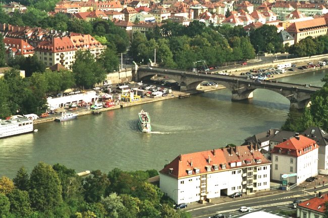 The Main River in Würzburg | |
 Position of the Main in Germany | |
| Location | |
| Country | Germany |
| Physical characteristics | |
| Source | |
| • location | Upper Franconia |
| • coordinates | 50°5′11″N 11°23′54″E |
| • elevation | 895 metres (at Weissmainquelle) |
| Mouth | |
• location | Rhine |
• coordinates | 49°59′40″N 8°17′36″E |
| Length | 524.9 km (326.2 mi) [1] |
| Basin size | 27,208 km2 (10,505 sq mi) [1] |
| Discharge | |
| • average | 200 m3/s (7,100 cu ft/s) |
| Basin features | |
| Progression | Rhine→ North Sea |
The largest cities on the Main are Frankfurt am Main, Offenbach am Main and Würzburg.[2] It is the longest river lying entirely in Germany (if the Weser-Werra are considered separate).
Geography
The Main flows through the north and north-west of the state of Bavaria then across southern Hesse; against the latter it demarcates a third state, Baden-Württemberg, east and west of Wertheim am Main, the northernmost town of that state.
The upper end of its basin opposes that of the Danube where the watershed is recognised by natural biologists, sea salinity studies (and hydrology science more broadly) as the European Watershed.
The Main begins near Kulmbach in Franconia at the joining of its two headstreams, the Red Main (Roter Main) and the White Main (Weißer Main). The Red Main originates in the Franconian Jura mountain range, 50 km (31 mi) in length, and runs through Creussen and Bayreuth. The White Main originates in the mountains of the Fichtelgebirge; it is 41 km (25 mi) long. In its upper and middle section, the Main runs through the valleys of the German Highlands. Its lower section crosses the Lower Main Lowlands (Hanau-Seligenstadt Basin and northern Upper Rhine Plain) to Wiesbaden, where it discharges into the Rhine. Major tributaries of the Main are the Regnitz, the Franconian Saale, the Tauber, and the Nidda.[3]
The name Main originates from Latin Moenis, Moenus or Menus. It is not related to the name of the city Mainz (Latin: Mogontiacum or Moguntiacum).
Navigation
The Main is navigable for shipping from its mouth at the Rhine close to Mainz for 396 km (246 mi) to Bamberg. Since 1992, the Main has been connected to the Danube via the Rhine-Main-Danube Canal and the highly regulated Altmühl river. The Main has been canalized with 34 large locks (300 × 12 m or 984 × 39 ft) to allow CEMT class V vessels (110 × 11.45 m or 360.9 × 37.6 ft) to navigate the total length of the river. The 16 locks in the adjacent Rhine-Main-Danube Canal and the Danube itself are of the same dimensions.[citation needed]
Weirs and locks

There are 34 weirs and locks along the 380 km navigable portion of the Main, from the confluence with the Regnitz near Bamberg, to the Rhine.[4]
- No.: Number of the lock (from upstream to downstream).
- Name: Name of the lock.
- Location: City or town where the lock is located.
- Year built: Year when the lock was put into operation (replacement dates are also listed where applicable).
- Main-km: Location on the Main, measured from the 0 km stone in Mainz-Kostheim. The reference point is the center of the lock or lock group.
- Distance between locks: length in km of impoundment (between adjacent locks).
- Altitude: height in meters above mean sea level of the upper water at normal levels.
- Height: Height of the dam in meters (the height of the Kostheim lock depends on the water level of the Rhine).
- Lock length: Usable length of the lock chamber in meters.
- Lock width: Usable width of the lock chamber in meters.
| No. | Name | Location | Year built | Main-km | Distance between locks (km) | Altitude (m) | Height (m) | Lock length (m) | Lock width (m) |
|---|---|---|---|---|---|---|---|---|---|
| 1 | Viereth | Viereth-Trunstadt | 1925 | 380.699 | 230.86 | 6.00 | 289.80 | 12.00 | |
| 2 | Limbach | Eltmann | 1951 | 367.176 | 13.523 | 224.86 | 5.36 | 299.10 | 12.00 |
| 3 | Knetzgau | Knetzgau (Haßfurt) | 1958 | 359.781 | 7.395 | 219.50 | 4.24 | 298.85 | 12.00 |
| 4 | Ottendorf | Gädheim | 1962 | 345.263 | 14.518 | 215.26 | 7.59 | 301.60 | 12.00 |
| 5 | Schweinfurt | Schweinfurt | 1963 | 332.037 | 13.226 | 207.67 | 4.67 | 300.60 | 12.00 |
| 6 | Garstadt | Bergrheinfeld | 1956 | 323.503 | 8.534 | 203.00 | 4.69 | 299.75 | 12.00 |
| 7 | Wipfeld | Wipfeld | 1950 | 316.289 | 7.214 | 198.31 | 4.31 | 300.15 | 12.00 |
| 8 | Gerlachshausen mit Volkach | Volkach (Schwarzach am Main) | 1957 | 300.506 | 15.783 | 194.00 | 6.30 | 300.00 | 12.00 |
| 9 | Dettelbach | Dettelbach | 1959 | 295.398 | 5.108 | 187.70 | 5.50 | 299.35 | 12.00 |
| 10 | Kitzingen | Kitzingen | 1956 | 283.979 | 11.419 | 182.20 | 3.66 | 299.80 | 12.00 |
| 11 | Marktbreit | Marktbreit (Frickenhausen am Main) | 1955 | 275.681 | 8.298 | 178.54 | 3.31 | 296.40 | 12.00 |
| 12 | Goßmannsdorf | Ochsenfurt | 1952 | 269.028 | 6.653 | 175.23 | 3.40 | 296.90 | 12.00 |
| 13 | Randersacker | Würzburg (Randersacker) | 1950 | 258.885 | 10.143 | 171.83 | 3.30 | 299.60 | 12.00 |
| 14 | Würzburg | Würzburg | 1954 | 252.512 | 6.373 | 168.53 | 2.75 | 293.10 | 12.00 |
| 15 | Erlabrunn | Erlabrunn (Thüngersheim) | 1935 | 241.204 | 11.308 | 165.78 | 4.15 | 299.20 | 12.00 |
| 16 | Himmelstadt | Himmelstadt | 1939 | 232.290 | 8.914 | 161.63 | 4.30 | 299.50 | 12.00 |
| 17 | Harrbach | Karlstadt (Gemünden am Main) | 1939 | 219.466 | 12.824 | 157.33 | 4.90 | 299.45 | 12.00 |
| 18 | Steinbach | Lohr am Main | 1939 | 200.673 | 18.793 | 152.43 | 5.14 | 299.10 | 12.00 |
| 19 | Rothenfels | Rothenfels (Marktheidenfeld) | 1937 | 185.887 | 14.786 | 147.29 | 5.26 | 298.45 | 12.00 |
| 20 | Lengfurt | Triefenstein | 1937 | 174.508 | 11.379 | 142.03 | 3.99 | 300.08 | 11.98 |
| 21 | Eichel | Wertheim | 1937 | 160.467 | 14.041 | 138.04 | 4.50 | 299.92 | 12.00 |
| 22 | Faulbach | Wertheim (Faulbach) | 1935 | 147.065 | 13.402 | 133.54 | 4.51 | 299.80 | 12.10 |
| 23 | Freudenberg | Collenberg (Freudenberg) | 1934 | 133.948 | 13.117 | 129.03 | 4.51 | 300.00 | 12.00 |
| 24 | Heubach | Großheubach (Miltenberg) | 1932 | 122.360 | 11.588 | 124.52 | 4.00 | 300.00 | 12.00 |
| 25 | Klingenberg | Klingenberg am Main | 1930 | 113.050 | 9.310 | 120.52 | 4.00 | 300.71 | 12.05 |
| 26 | Wallstadt | Kleinwallstadt (Großwallstadt) | 1930 | 101.203 | 11.847 | 116.52 | 4.00 | 299.93 | 12.00 |
| 27 | Obernau | Niedernberg (Aschaffenburg) | 1930 | 92.909 | 8.294 | 112.52 | 4.01 | 299.18 | 12.00 |
| 28 | Kleinostheim | Kleinostheim (Stockstadt am Main) | 1920 1972 | 77.905 | 15.004 | 108.51 | 6.80 | 298.36 298.22 | 12.04 12.02 |
| 29 | Krotzenburg | Hainburg (Großkrotzenburg) | 1920 1983 | 63.850 | 14.055 | 101.71 | 2.74 | 302.30 300.01 | 12.00 12.00 |
| 30 | Mühlheim (formerly Kesselstadt) | Maintal (Mühlheim am Main) | 1920 1980 | 53.185 | 10.385 | 98.97 | 3.77 | 299.90 | 12.04 |
| 31 | Offenbach | Frankfurt am Main (Offenbach am Main) | 1901 1957 | 38.514 | 14.671 | 95.20 | 3.18 | 344.03 230.07 | 12.09 13.05 |
| 32 | Griesheim | Frankfurt am Main | 1934 | 28.687 | 9.827 | 92.02 | 4.49 | 344.05 344.38 | 12.00 15.00 |
| 33 | Eddersheim | Hattersheim am Main (Kelsterbach) | 1934 | 15.551 | 13.136 | 87.53 | 3.61 | 345.46 344.26 | 12.05 15.05 |
| 34 | Kostheim | Hochheim am Main (Ginsheim-Gustavsburg) | 1886 1934 | 3.209 | 12.342 | 83.92 | 2.36 (MW Rhine) | 341.90 339.02 | 15.00 Door: 12.00 Chamber: 20.00 |
Hydroelectric power generation
Most of the weirs or dams along the Main also have turbines for power generation.
- No.: Number of the dam/weir (from upstream to downstream).
- Name: Name of the dam/weir.
- Height: Height of the dam/weir in meters (the height of the Kostheim dam depends on the water level of the Rhine).
- Power: Maximum power generation capacity in megawatts.
- Turbines: Type and number of turbines.
- Operator: Operator of the hydroelectric plant.
| No. | Name | Height (m) | Power (MW) | Turbines | Operator |
|---|---|---|---|---|---|
| 1 | Viereth | 6.00 | 6.20 | Francis(3), Kaplan(1) | E.ON Wasserkraft |
| 2 | Limbach | 5.36 | 3.70 | Kaplan(2) | E.ON Wasserkraft |
| 3 | Knetzgau | 4.24 | 2.90 | Kaplan(2) | E.ON Wasserkraft |
| 4 | Ottendorf | 7.59 | 6.30 | Kaplan(2) | E.ON Wasserkraft |
| 5 | Schweinfurt | 4.67 | 3.80 | Kaplan(2) | E.ON Wasserkraft |
| 6 | Garstadt | 4.69 | 3.90 | Kaplan(2) | E.ON Wasserkraft |
| 7 | Wipfeld | 4.31 | 2.90 | Kaplan(2) | E.ON Wasserkraft |
| 8 | Gerlachshausen mit Volkach | 6.30 | 3.90 | Kaplan(2) | E.ON Wasserkraft |
| 9 | Dettelbach | 5.50 | 4.20 | Kaplan(2) | E.ON Wasserkraft |
| 10 | Kitzingen | 3.66 | 3.00 | Kaplan(2) | E.ON Wasserkraft |
| 11 | Marktbreit | 3.31 | 2.10 | Kaplan(2) | E.ON Wasserkraft |
| 12 | Goßmannsdorf | 3.40 | 2.00 | Kaplan(2) | E.ON Wasserkraft |
| 13 | Randersacker | 3.30 | 2.00 | Kaplan(2) | E.ON Wasserkraft |
| 14 | Würzburg | 2.75 | 0.90 | Kaplan(3) | E.ON Wasserkraft |
| 15 | Erlabrunn | 4.15 | 2.70 | Kaplan(1) | E.ON Wasserkraft |
| 16 | Himmelstadt | 4.30 | 2.50 | Kaplan(1) | E.ON Wasserkraft |
| 17 | Harrbach | 4.90 | 3.00 | Kaplan(2) | E.ON Wasserkraft |
| 18 | Steinbach | 5.14 | 4.20 | Kaplan(2) | E.ON Wasserkraft |
| 19 | Rothenfels | 5.26 | 4.20 | Kaplan(2) | E.ON Wasserkraft |
| 20 | Lengfurt | 3.99 | 2.60 | E.ON Wasserkraft | |
| 21 | Eichel | 4.50 | 3.10 | E.ON Wasserkraft | |
| 22 | Faulbach | 4.51 | 4.10 | E.ON Wasserkraft | |
| 23 | Freudenberg | 4.51 | 4.30 | E.ON Wasserkraft | |
| 24 | Heubach | 4.00 | 3.40 | E.ON Wasserkraft | |
| 25 | Klingenberg | 4.00 | 3.00 | E.ON Wasserkraft | |
| 26 | Wallstadt | 4.00 | 3.40 | E.ON Wasserkraft | |
| 27 | Obernau | 4.01 | 3.20 | E.ON Wasserkraft | |
| 28 | Kleinostheim | 6.80 | 9.70 | E.ON Wasserkraft | |
| 29 | Krotzenburg | 2.74 | — | ||
| 30 | Mühlheim | 3.77 | 4.80 | E.ON Wasserkraft | |
| 31 | Offenbach | 3.18 | 4.10 | E.ON Wasserkraft | |
| 32 | Griesheim | 4.49 | 4.90 | Kaplan(3) | Wasser- und Schifffahrtsamt Aschaffenburg |
| 33 | Eddersheim | 3.61 | 3.84 | Kaplan(3) | Wasser- und Schifffahrtsamt Aschaffenburg |
| 34 | Kostheim | 2.36 | 4.9 | Kaplan Pit-Rohrturbinen(2) | WKW Staustufe Kostheim/Main GmbH & Co. KG (Gebaut und Betrieben von Stadtwerke Ulm/Neu-Ulm) |
Tributaries

Tributaries from source to mouth:
|
Left |
Right
|
 The Main in Frankfurt at night
 Main in Offenbach am Main
 Confluence into the Rhine at Mainz-Kostheim


Ports and municipalities
Around Frankfurt are several large inland ports. Because the river is rather narrow on many of the upper reaches, navigation with larger vessels and push convoys requires great skill.
The largest cities along the Main are Frankfurt am Main, Offenbach am Main and Würzburg. The Main also passes the following towns: Burgkunstadt, Lichtenfels, Bad Staffelstein, Eltmann, Haßfurt, Schweinfurt, Volkach, Kitzingen, Marktbreit, Ochsenfurt, Karlstadt, Gemünden, Lohr, Marktheidenfeld, Wertheim, Miltenberg, Obernburg, Erlenbach/Main, Aschaffenburg, Seligenstadt, Hainburg, Hanau, Hattersheim, Flörsheim, and Rüsselsheim.
The river has gained enormous importance as a vital part of European "Corridor VII", the inland waterway link from the North Sea to the Black Sea.[5]
Main line
In a historical and political sense, the Main line is referred to as the northern border of Southern Germany, with its predominantly Catholic population. The river roughly marked the southern border of the North German Federation, established in 1867 under Prussian leadership as the predecessor of the German Empire.
The river course also corresponds with the Speyer line isogloss between Central and Upper German dialects, sometimes mocked as Weißwurstäquator.[6][7]
Recreation
The Main-Radweg is a major German bicycle path alongside the river. Approximately 600 kilometres long (370 mi), it is the first long-distance instance awarded 5 stars by the General German Bicycle Club (ADFC) in 2008. It starts from Creußen or Bischofsgrün and ends in Mainz.[8]
Sights
- Roman camp at Marktbreit
Notes and references
- Footnotes
- The Bavarian authorities define the source of the White Main as the source of the Main itself, although the sources of the Red Main and the Franconian Rezat are actually further from the Rhine.
- Citations
- Complete table of the Bavarian Waterbody Register by the Bavarian State Office for the Environment (xls, 10.3 MB)
- "Main River | river, Germany". Encyclopedia Britannica. Retrieved 2021-02-04.
- Uehlinger, Urs; Wantzen, Karl; Leuven, Rob S.E.W.; Arndt, Hartmut (2009). "The Rhine River Basin". In Tockner, Klement; Uehlinger, Urs; Robinson, Christopher T. (eds.). Rivers of Europe. Academic Press. pp. 238–239. doi:10.1016/B978-0-12-369449-2.00006-0. ISBN 9780123694492. S2CID 16401687.
- "Daten und Fakten" [Facts and figures] (in German). Wasser- und Schifffahrtsdirektion Süd. June 2003. Archived from the original on 13 June 2013. Retrieved 7 June 2009.
- "NoorderSoft Waterways Database". Retrieved 2007-10-24.
- Qvale, Per (12 May 2014). From St Jerome to Hypertext: Translation in Theory and Practice. Routledge. p. 117. ISBN 978-1-317-64053-0.
- Carrington-Windo, Tristam; Kohl, Katrin (11 April 2013). Dictionary of Contemporary Germany. Routledge. ISBN 978-1-136-59537-0.
- "Main-Radweg". Archived from the original on 7 November 2019. Retrieved 23 April 2013.
Bibliography
- Haus der Bayerischen Geschichte (ed.), Main und Meer - Porträt eines Flusses. Exhibition Catalogue to the Bayerische Landesausstellung 2013 (German). WBG. ISBN 978-3-534-00010-4.
External links
- Main River Website on the River Main by the Tourist Board of Franconia. (in English)
- . Collier's New Encyclopedia. 1921.
- . . 1914.
- There is literature about Main (river) in the Hessian Bibliography
- Water levels of Bavarian rivers
- Wasser- und Schifffahrtsdirektion Süd
- Main Cycleway
- Historical map of the Main confluence at Steinenhausen from BayernAtlas

Authority control | |
|---|---|
| General | |
| National libraries | |
На других языках
[de] Main
Der Main ist mit 527 Kilometern Fließstrecke der längste rechte Nebenfluss des Rheins.- [en] Main (river)
[it] Meno (fiume)
Il Meno (in tedesco Main), dalla lunghezza di circa 524 km è il più grande affluente destro del Reno, al quale si congiunge presso Magonza; il suo corso si distende interamente in Germania e lo rende il primo fiume tedesco per lunghezza interamente in territorio teutonico.[ru] Майн
Майн (нем. Main, лат. Moenus) — река в Германии, правый приток Рейна. Длина реки составляет 524[1] км, площадь водосборного бассейна — 27 292 км². Майн является самой длинной рекой, протекающей исключительно в Германии.Другой контент может иметь иную лицензию. Перед использованием материалов сайта WikiSort.org внимательно изучите правила лицензирования конкретных элементов наполнения сайта.
WikiSort.org - проект по пересортировке и дополнению контента Википедии