geo.wikisort.org - River
The Tamina is a river in Switzerland that originates on the flanks of Piz Sardona in the Glarus Alps and flows eastwards and northwards to finally merge with the Alpine Rhine after about 18 km total length.[1]
This article needs additional citations for verification. (August 2022) |
| Tamina | |
|---|---|
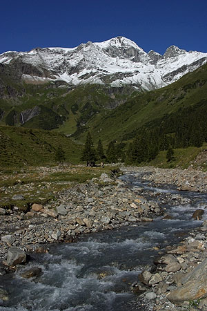 Tamina (Calfeisental) | |
| Location | |
| Country | Switzerland |
| Physical characteristics | |
| Source | |
| • location | Egghorn |
| • elevation | 2,600 m (8,500 ft) |
| Mouth | |
• location | Rhine |
| Length | ~ 18 km (11 mi) |
| Basin features | |
| Progression | Rhine→ North Sea |
Along its way it flows into the reservoir Lake Gigerwald in the Calfeisen valley. At Vättis it is joined by the Gorbsbach, and flows northeast into the Mapraggsee. The lower section, heading northwards through Bad Pfäfers, forms a deep and narrow gorge called the Taminaschlucht.[2] Finally, it meets the Rhine river near Bad Ragaz.[1]
Historically, the Tamina valley (Taminatal, also Vättnertal) was owned by the Pfäfers Abbey, joined to the canton of St. Gallen at its formation in 1803.
References
- Scheidegger, Adrian E. (2012-12-06). Morphotectonics. Springer Science & Business Media. ISBN 978-3-642-18745-2.
- Reynard, Emmanuel (2020-07-09). Landscapes and Landforms of Switzerland. Springer Nature. ISBN 978-3-030-43203-4.
Authority control | |
|---|---|
| General |
|
| National libraries | |
This Canton of St. Gallen location article is a stub. You can help Wikipedia by expanding it. |
На других языках
[de] Tamina (Fluss)
Die Tamina ist ein etwa 30 km langer Fluss im Kanton St. Gallen. Sie ist ein linker und südsüdwestlicher Zufluss des Rheins.- [en] Tamina (river)
Другой контент может иметь иную лицензию. Перед использованием материалов сайта WikiSort.org внимательно изучите правила лицензирования конкретных элементов наполнения сайта.
WikiSort.org - проект по пересортировке и дополнению контента Википедии