geo.wikisort.org - Island
Texel (Dutch pronunciation: [ˈtɛsəl] (![]() listen); Texels dialect: Tessel) is a municipality and an island with a population of 13,643 in North Holland, Netherlands. It is the largest and most populated island of the West Frisian Islands in the Wadden Sea. The island is situated north of Den Helder, northeast of Noorderhaaks, and southwest of Vlieland.
listen); Texels dialect: Tessel) is a municipality and an island with a population of 13,643 in North Holland, Netherlands. It is the largest and most populated island of the West Frisian Islands in the Wadden Sea. The island is situated north of Den Helder, northeast of Noorderhaaks, and southwest of Vlieland.
This article needs additional citations for verification. (May 2015) |
Texel | |
|---|---|
Municipality and island | |
 North end of the island with the Eierland Lighthouse in 2015 | |
 Flag  Coat of arms | |
 Location in North Holland | |
| Coordinates: 53°3′N 4°48′E | |
| Country | Netherlands |
| Province | North Holland |
| Government | |
| • Body | Municipal council |
| • Mayor | Michiel Uitdehaag (D66) |
| Area | |
| • Total | 463.16 km2 (178.83 sq mi) |
| • Land | 162.00 km2 (62.55 sq mi) |
| • Water | 301.16 km2 (116.28 sq mi) |
| Elevation | 2 m (7 ft) |
| Population (January 2019)[4] | |
| • Total | 13,547 |
| • Density | 84/km2 (220/sq mi) |
| Demonym(s) | Tesselaar, Texelaar |
| Time zone | UTC+1 (CET) |
| • Summer (DST) | UTC+2 (CEST) |
| Postcode | 1790–1797 |
| Area code | 0222 |
| Website | www |
Name
The name Texel is Frisian, but because of historical sound-changes in Dutch, where all -x- sounds have been replaced with -s- sounds (compare for instance English fox, Frisian fokse, German Fuchs with Dutch vos), the name is typically pronounced Tessel in Dutch.[5]
History
The All Saints' Flood (1170) created the islands of Texel and Wieringen from North Holland.[6] In the 13th century Ada, Countess of Holland was held prisoner on Texel by her uncle, William I, Count of Holland.
Texel received city rights in 1415.
The first Dutch expedition to the Northwest Passage departed from the island on the 5th of June, 1594.
Texel was involved in the Battle of Scheveningen (1653) during the First Anglo-Dutch War and the Battle of Texel (1673) during the Third Anglo-Dutch War.


During the American Revolution, Texel was used as a haven port by John Paul Jones after the Battle of Flamborough Head off the Yorkshire coast in September 1779. In that action, Jones defeated and captured the British ship Serapis, which he sailed to Texel for desperately needed repairs. This event further complicated Anglo-Dutch relations.
In 1797, Texel was involved in the Battle of Camperdown during the French Revolutionary Wars.
During the First World War in 1914, the Battle off Texel took place off the coast of Texel.
On the night of 31 August 1940, the sea to the northwest of Texel was the scene of the sinking of two British destroyers and the severe damage of a third by German mines in what is known as the Texel Disaster.
At the end of the Second World War in 1945, the Georgian uprising on Texel took place on the island. Following a German decision to redeploy Georgian soldiers to the mainland, they revolted and killed hundreds of their German comrades while they slept. The uprising lasted from 5 April 1945 until 20 May 1945, two weeks after V-E Day. At that point, Canadian troops arrived and arranged for the two sides to separately leave the island. For that reason, the uprising is often referred to as the final battle of the Second World War in Europe. Hundreds of Georgians who died fighting against the Germans are buried in a special cemetery on Texel commonly known as the "Russian cemetery".[7]
Geography
The municipality is located at 53°3′N 4°48′E north of the mainland of the province of North Holland and west of the mainland of the province of Friesland. The island of Texel is situated north of the city of Den Helder, northeast of the uninhabited island of Noorderhaaks, which is part of the municipality, and southwest of the island of Vlieland.
The island includes the seven villages:
and the small townships of
- Bargen
- De Nes
- Dijkmanshuizen
- Driehuizen
- Harkebuurt
- 't Horntje
- Midden-Eierland
- Molenbuurt
- Nieuweschild
- Noorderbuurt
- Ongeren
- Oost
- Spang
- Spijkdorp
- Tienhoven
- Westermient
- Zevenhuizen
- Zuid-Eierland
The island of Texel was originally made up of two islands, Texel proper to the south and Eierland to the northeast, which were connected by shoals. In the early seventeenth century, the islands were connected by a dyke to keep the North Sea from ravaging the coastal areas of Texel proper. In the mid-nineteenth century a polder completed the northern half of the island. Today, Texel forms the largest natural barrier between the North Sea and the Wadden Sea.
The dune landscape along the western coast of the island is protected as Dunes of Texel National Park.
Landscape
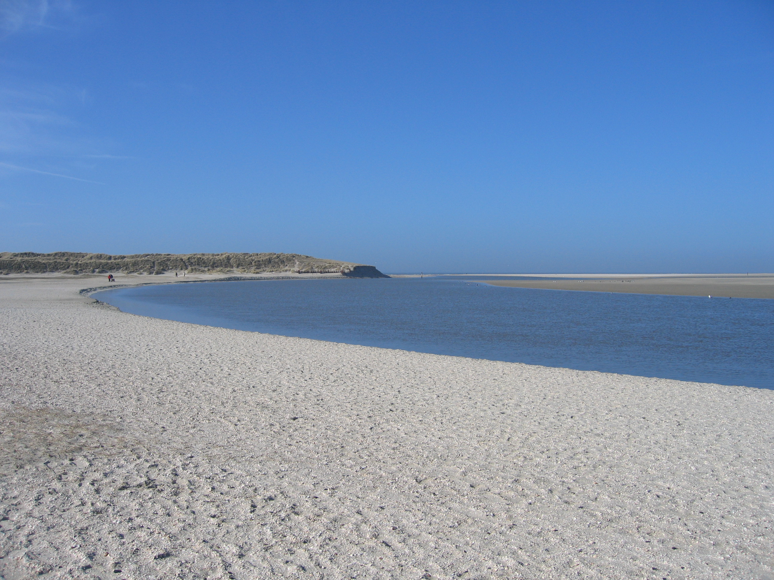
The island is 23.7 km long and 9.6 km wide, its surface is 169.82 square kilometres. The highest point of the island is not, as one might assume, de Hoge Berg (15 m above sea level), but the dune "Bertusnol" (also "Nol van Bertus"), which is situated in the Dunes of Texel National Park, at 19.6 m. The dune landscape on Texel is a unique habitat for wildlife. Notable areas include De Slufter, where the tide comes in and meets the dunes, forming a marshy environment rich in both fauna and flora. Texel is known for its wildlife, particularly in winter, when birds of prey and geese take up residence. About one third of Texel is a protected nature reserve. A wetland called Utopia has been designed for birds to nest in.[8]
Gallery
 The Dunes of Texel National Park
 Texel Landscape
 De Koog - Koogerstrand - View Northwest
 Dunes on Texel
 Beach on the island of Texel
 Duinen van Texel
 Nature and environment excursion in De Slufter
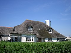 Texel
Texel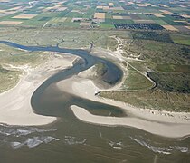 Aerial view of De Slufter
 Northern tip of Texel (Vlieland in the distance)


Climate
Texel has an oceanic climate (Köppen Cfb) that is heavily influenced by its offshore position. The annual average high oscillation is between 5 °C (41 °F) and 21 °C (70 °F). While winters are similar to mainland areas, summers remain cooler. The relative proximity to the mainland still renders heat bursts to reach Texel with five months having recorded temperatures above 30 °C (86 °F). While the island is relatively rainy, the precipitation is generally quite even and moderate throughout most of the year although there is a dry peak in late spring and a rain peak in autumn.
| Climate data for Texel | |||||||||||||
|---|---|---|---|---|---|---|---|---|---|---|---|---|---|
| Month | Jan | Feb | Mar | Apr | May | Jun | Jul | Aug | Sep | Oct | Nov | Dec | Year |
| Record high °C (°F) | 13.7 (56.7) |
14.9 (58.8) |
20.5 (68.9) |
27.9 (82.2) |
31.0 (87.8) |
31.7 (89.1) |
34.6 (94.3) |
33.8 (92.8) |
32.6 (90.7) |
24.8 (76.6) |
17.7 (63.9) |
15.3 (59.5) |
34.6 (94.3) |
| Average high °C (°F) | 5.5 (41.9) |
5.5 (41.9) |
8.3 (46.9) |
11.7 (53.1) |
15.4 (59.7) |
18 (64) |
20.3 (68.5) |
20.6 (69.1) |
17.9 (64.2) |
14 (57) |
9.7 (49.5) |
6.4 (43.5) |
12.8 (54.9) |
| Average low °C (°F) | 1.2 (34.2) |
0.8 (33.4) |
2.8 (37.0) |
5 (41) |
8.6 (47.5) |
11.3 (52.3) |
13.8 (56.8) |
14 (57) |
11.7 (53.1) |
8.5 (47.3) |
4.9 (40.8) |
2 (36) |
7.1 (44.7) |
| Record low °C (°F) | −18.8 (−1.8) |
−18.5 (−1.3) |
−14.5 (5.9) |
−4.8 (23.4) |
−2.1 (28.2) |
1.5 (34.7) |
5.2 (41.4) |
5.6 (42.1) |
3.0 (37.4) |
−4.6 (23.7) |
−10.8 (12.6) |
−12.3 (9.9) |
−18.8 (−1.8) |
| Average precipitation mm (inches) | 66.2 (2.61) |
44.4 (1.75) |
52.4 (2.06) |
33.7 (1.33) |
45 (1.8) |
54.1 (2.13) |
59.8 (2.35) |
76.8 (3.02) |
83.7 (3.30) |
95.9 (3.78) |
83.5 (3.29) |
69.8 (2.75) |
765.3 (30.17) |
| Mean monthly sunshine hours | 64.1 | 91.1 | 134.8 | 194.2 | 235.2 | 219 | 228.2 | 208.2 | 148 | 114.2 | 63.1 | 51 | 1,751.1 |
| Source 1: [9] | |||||||||||||
| Source 2: [10] | |||||||||||||
Notable people


- Willem Eduard Bok (1846 in Den Burg – 1904), a Dutch-born South African Boer politician, civil servant and statesman
- Willem Hendrik Keesom (1876 in Texel – 1956), a Dutch physicist who first froze liquid helium
- Sim Visser (1908 in Eierland – 1983), a Dutch politician
- Cornelis de Jager (1921 in Den Burg - 2021), a Dutch astronomer who predicts solar variation
- Imme Dros (born 1936 in Oudeschild), a Dutch writer of children's literature
- Hans Kamp (born 1940 in Den Burg), a Dutch philosopher and linguist, introduced Discourse Representation Theory
- Rene Daalder (1944–2019), a Dutch writer and director[11]
- Henk Zijm (born 1952 in Driehuizen), a Dutch mathematician from the University of Twente
Sport
- Alice Blom (born 1980 in Oudeschild), a volleyball player
- Dorian van Rijsselberghe (born 1988 in Den Burg), a sailor, gold medallist at the 2012 and 2016 Summer Olympics
- Denise Betsema (born 1993 in Oudeschild), a cyclo-cross cyclist
Economy
The tourism industry forms a substantial part of the economy in Texel. Approximately 70% of activities on Texel are in some way related to tourism. Popular forms of tourism on Texel include cycling, walking, swimming and horse riding. Farming (sheep, potatoes, dairy, tulips, and grain) and fishing (primarily from Oudeschild) are traditional. Locally brewed beer is sold under the tradename Texels.
Local government

The municipal council of Texel consists of 15 seats, which are divided as follows (from the most recent election results in 2018:
- Texels Belang, 4 seats
- VVD, 3 seats
- PvdA, 2 seats
- GroenLinks, 2 seats
- CDA, 2 seats
- D66, 1 seat
- Texel 2010, 1 seat
Transport
![Ferry MS Dokter Wagemaker (2) [nl] from Den Helder to Texel in 2005](http://upload.wikimedia.org/wikipedia/commons/c/c5/Dokter_Wagemaker_3.jpg)
Transport around the island is typically by bicycle, bus (Texelhopper) or car. Texel has an extensive cycle path network. Transport to Texel is easiest by a very short ferry trip Royal TESO), from Den Helder, or by air via Texel International Airport. The ferry Texelstroom uses 80% compressed natural gas.[12]
See also
- Grand Hotel Opduin
- Texel sheep
References
- "B&W samenstelling en portefeuilles" [Mayor and aldermen members and tasks] (in Dutch). Gemeente Texel. Archived from the original on 27 July 2014. Retrieved 22 March 2014.
- "Kerncijfers wijken en buurten 2020" [Key figures for neighbourhoods 2020]. StatLine (in Dutch). CBS. 24 July 2020. Retrieved 19 September 2020.
- "Postcodetool for 1791AT". Actueel Hoogtebestand Nederland (in Dutch). Het Waterschapshuis. Retrieved 22 March 2014.
- "Bevolkingsontwikkeling; regio per maand" [Population growth; regions per month]. CBS Statline (in Dutch). CBS. 1 January 2019. Retrieved 1 January 2019.
- Donaldson, Bruce C. (1983). Dutch: A Linguistic History of Holland and Belgium. Leiden: Martinus Nijhoff. p. 151. ISBN 9789024791668.
- Ley, Willy (October 1961). "The Home-Made Land". For Your Information. Galaxy Science Fiction. pp. 92–106.
- Lee, Eric (2020). Night of the Bayonets: The Texel Uprising and Hitler's Revenge, April–May 1945. London: Greenhill Books. ISBN 9781784384685.
- Utopia voor vogels
- "Klimaatatlas| KNMI". knmi.nl. Retrieved 8 March 2015.
- "www.weergegevens.nl". Retrieved 9 March 2015.
- IMDb Database retrieved 06 July 2019
- "Norske Umoe har levert verdens første trykktanker i kompositt til skip". Teknisk Ukeblad. 30 January 2017. Retrieved 31 January 2017.
External links
- Official website

 Texel travel guide from Wikivoyage
Places adjacent to Texel | ||||||||||||||||
|---|---|---|---|---|---|---|---|---|---|---|---|---|---|---|---|---|
| ||||||||||||||||
Municipalities of North Holland | ||
|---|---|---|
|  | |
| ||
| West Frisian Islands (Netherlands) |
|  | |||||
|---|---|---|---|---|---|---|---|
| East Frisian Islands (Germany) |
| ||||||
| Heligoland Bight (Germany) |
| ||||||
| North Frisian Islands (Germany) |
| ||||||
| Danish Wadden Sea Islands (Denmark) |
| ||||||
Authority control | |
|---|---|
| National libraries | |
| Other |
|
На других языках
[de] Texel
Texel [.mw-parser-output .IPA a{text-decoration:none}ˈtɛsəl] ( anhören?/i) (westfriesisch Tessel) ist eine Nordseeinsel in der niederländischen Provinz Nordholland sowie der Name der auf ihr liegenden Gemeinde. Die Insel ist die westlichste bewohnte und größte Westfriesische Insel. Sie ist ein beliebtes Tourismusziel; ihre vielfältige Landschaft beherbergt eine reichhaltige Tier- und Pflanzenwelt.- [en] Texel
[es] Texel
Texel ( [ˈtɛsəl] (?·i), en frisón occidental, Tessel) es una isla y también un municipio de los Países Bajos, la más grande de las islas Frisias y a su vez la más occidental. Está situada entre el mar de Frisia (al este) y el mar del Norte (al oeste), al sur de la isla de Vlieland y al norte de tierra firme de la provincia de Holanda Septentrional, a la cual pertenece administrativamente. El estrecho de Marsdiep la separa de Den Helder, ya en tierra firme.[ru] Тексел (остров)
Те́ксел (Тессел, нидерл. Texel, МФА: [ˈtɛsəl]) — остров в Нидерландах, в провинции Северная Голландия. Самый крупный и наиболее населённый из Западно-Фризских островов. На острове располагается одноимённая община. Ещё в 1415 году остров получил городские права[1]. Площадь территории, подчинённой общинному совету Тесела, составляет 585,96 км², хотя бо́льшая часть (416,14 км²) приходится на акваторию. Таким образом, формально Тексел является самым большим городом Нидерландов по площади.Другой контент может иметь иную лицензию. Перед использованием материалов сайта WikiSort.org внимательно изучите правила лицензирования конкретных элементов наполнения сайта.
WikiSort.org - проект по пересортировке и дополнению контента Википедии