geo.wikisort.org - Island
The North Frisian Islands (Öömrang and Fering North Frisian: Nuurdfresk Eilunen, Söl'ring North Frisian: Nuurđfriisk Ailönen, Danish: Nordfrisiske Øer, German: Nordfriesische Inseln) are the Frisian Islands off the coast of North Frisia.
 | |
| Geography | |
|---|---|
| Location | North Sea |
| Total islands | 13 |
| Major islands | Sylt, Föhr, Amrum, Pellworm |
| Administration | |
Germany | |
| State | Schleswig-Holstein |
| District | Nordfriesland |
| Demographics | |
| Ethnic groups | Germans, Frisians, Danes |
The term covers both the North Frisian Islands in the narrow sense (in Schleswig-Holstein, Germany) and the Danish Wadden Sea Islands (in Denmark). However, culturally and linguistically, the Danish islands are usually not reckoned as being part of North Frisia, since they are not inhabited by native speakers of the North Frisian language. Occasionally, the remote island of Heligoland is also included in this group for reasons of administrative convenience, despite not being located in the Wadden Sea, since the island is home to its own unique dialect of Frisian.
History
After the Frisian and Danish colonisation of the islands in the 8th century, the Frisian-populated hundreds (between Eiderstedt and Sylt) became the Uthlande. The North Frisians in the Uthlande were ruled directly by the Danish king and were known as Königsfriesen or "King's Frisians". Only later did the Uthlande transfer to the Duchy of Schleswig, with the exception of small Danish royal enclaves. Part of Rømø was also ruled by the Schleswig duke. After the German-Danish wars, the islands from Nordstrand to Rømø became Prussian in 1866. After the referendum in 1920, the current border between the islands of Sylt and Rømø was fixed.
A good and thorough overview of the life, work, languages, costumes and customs of the island Frisians is portrayed by the Carl Haeberlin Frisian Museum in Wyk auf Föhr.
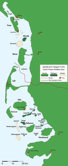
Islands
There are four larger islands and ten tiny islets. The names of the large islands are Sylt, Föhr, Amrum, and Pellworm. The islets are called Halligen. In medieval times, the present-day peninsula Nordstrand and Pellworm as well as the Halligen were part of the large island of Strand. This island was torn to pieces in a disastrous storm tide in 1634.

Sylt (Söl'ring North Frisian: Söl' ; Danish: Sild) is the largest of the North Frisian Islands, consisting of about 100 km². It is accessible by a causeway called the Hindenburgdamm; this causeway is only accessible to trains. In the summer months, the island is crowded with tourists, including those who have a preference for nudism. Sylt's image is that of a meeting point for the jet-set. The main town on the island is Westerland. The northern end of Sylt, the Ellenbogen ("elbow"), is Germany's northernmost point. Lager Sylt, the Nazi concentration camp on Alderney, was named after the island.
Compared with Sylt, Föhr (Fering North Frisian: Feer; Danish: Før) is a relatively silent island. Its area is 82 km². Sixteen old hamlets are scattered over the island, some of which already existed in the 13th century. The main town is Wyk on the south eastern shore. Wyk is a popular German seaside resort. There is no bridge or causeway connecting Föhr and the mainland, so ferries are the only connection. The ferry port, the harbour and Föhr marina are in Wyk.
Amrum (Öömrang North Frisian: Oomram) is only 20 km², but it is popular with tourists, though less crowded than Sylt. The western half of the island features a beach 12 km in length and 1 km in width. The villages are situated on the eastern shore, with Wittdün being the most important of them.
Pellworm (North Frisian Polweerm; Mooring North Frisian: Pälweerm; Danish: Pelvorm) and the peninsula of Nordstrand (Mooring: Nordströön) are the remains of the submerged island of Strand. The main town of this sunken island was Rungholt, thought to be the largest town in the surrounding area, but it was totally destroyed and submerged by a storm in 1362, 272 years before another storm destroyed Strand itself. Nordstrand has an area of 49 km², Pellworm 37 km².
Smaller remains of Strand are the ten islets called Halligen. The houses on these tiny islets are built on artificial hills. In a storm tide only these hills rise above the sea, while the remainder of the islet is flooded. The names of the Halligen are Nordmarsch-Langeness, Norderoog, Süderoog, Nordstrandischmoor, Oland, Südfall, Gröde-Appelland, Hooge, Habel and the Hamburger Hallig.
West off the Halligen, three drying sandbanks form the so-called North Frisian Barrier Islands: Japsand, Norderoogsand and Süderoogsand.
See also
References
- Wernicke, Klaus; Riecken, Guntram (1992). Nordfriesische Inseln und Halligen [North Frisian Islands and Halligen] (in German). Neumünster: Karl Wachholtz Verlag. ISBN 3-529-05505-0.
- Eckert, Gerhard (1974). Nordfriesische Inseln und Küstenbadeorte [North Frisian Islands and Coastal Resorts] (in German). Frankfurt am Main: Umschau Verlag. ISBN 3-524-00299-4.
- am Zehnhoff, Albert (1979). Sylt, Amrum, Föhr, Helgoland, Pellworm, Nordstrand und Halligen. Natur und Kultur auf Helgoland und den Nordfriesischen Inseln. Entdeckungsreisen durch eine Landschaft zwischen Meer und Festlandküste [Sylt, Amrum, Föhr, Helgoland, Pellworm, Nordstrand and the Halligen. Nature and Culture on Heligoland and the North Frisian Islands. A Discovery Voyage through a Landscape between Sea and Shore.] (in German). Cologne: DuMont. ISBN 3-7701-1093-5.
- Koehn, Henry; Häberlin, Carl; Tedsen, Julius; Warnecke, Georg (1961). Die Nordfriesischen Inseln [The North Frisian Islands] (in German). Berlin: Walter de Gruyter. ISBN 3-11-000564-6.
- Koehn, Henry (1954). Die Nordfriesischen Inseln. Die Entwicklung ihrer Landschaft und die Geschichte ihres Volkstums [The North Frisian Islands. Development of their Landscape and History of their Popular Culture] (in German). Hamburg: Walter de Gruyter.
- Zeisse, O. (1990). Beiträge zur Geologie der Nordfriesischen Inseln [Contributions to the Geology of the North Frisian Islands] (in German) (Reprint of the 1888 original ed.). ISBN 3-86031-121-2.
- Weigelt, G. (1873). Die nordfriesischen Inseln vormals und jetzt. Eine Skizze des Landes und seiner Bewohner [The North Frisian Islands Once and Today. A Sketch of the Land and its Inhabitants] (in German). Hamburg: Meissner.
- Kunz, Harry; Panten, Albert (1997). Die Köge Nordfrieslands [The Polders of North Frisia] (in German). Bredstedt: Nordfriisk Instituut. ISBN 3-88007-251-5.
| West Frisian Islands (Netherlands) |
|  | |||||
|---|---|---|---|---|---|---|---|
| East Frisian Islands (Germany) |
| ||||||
| Heligoland Bight (Germany) |
| ||||||
| North Frisian Islands (Germany) |
| ||||||
| Danish Wadden Sea Islands (Denmark) |
| ||||||
Authority control | |
|---|---|
| General |
|
| National libraries | |
На других языках
[de] Nordfriesische Inseln
Die Nordfriesischen Inseln liegen vor der Westküste Schleswig-Holsteins im nordfriesischen Wattenmeer, einem Teil der Nordsee. Sie sind vom Nationalpark Schleswig-Holsteinisches Wattenmeer umgeben, selbst jedoch nicht Bestandteil des Schutzgebietes. Neben den größeren Inseln Sylt, Föhr, Amrum, Pellworm und Nordstrand gibt es kleinere sogenannte Halligen, die in der Regel nicht mit Deichen vor Hochwasser geschützt sind und deren Bebauung auf Warften steht. Sie alle gehören zum Kreis Nordfriesland.- [en] North Frisian Islands
[es] Islas Frisias septentrionales
Las islas Frisias septentrionales (en alemán, Nordfriesische Inseln; en danés, Nordfrisiske Øer; en frisón septentrional, Nuurdfresk Eilunen) constituyen un grupo de islas localizadas en el mar de Frisia, que se extienden desde la desembocadura del Elba hacia el norte, hasta la altura de Esbjerg, paralelas a la costa de Jutlandia. Administrativamente se encuentran repartidas entre Alemania y Dinamarca. A este grupo pertenecen:[fr] Îles frisonnes septentrionales
Les îles frisonnes septentrionales sont un groupe d'îles côtières de la mer du Nord, séparée du continent par la mer de Wadden, au large des côtes du Schleswig-Holstein, en Allemagne. Les îles allemandes font partie de la région traditionnelle de la Frise du Nord, partie allemande de la Frise. Elles font partie du Parc national de la mer de Wadden et du Schleswig-Holstein.[it] Isole Frisone Settentrionali
Le isole Frisone Settentrionali sono situate a ridosso della costa occidentale dello Schleswig-Holstein (Germania) e dello Jütland (Danimarca) nel mare del Nord. Sono circondate dal parco nazionale del Wattenmeer dello Schleswig-Holstein ma non ne fanno parte.[ru] Северо-Фризские острова
Се́веро-Фри́зские острова́ (нем. Nordfriesische Inseln, дат. Nordfrisiske Øer, с.-фриз. Nuurdfresk eilunen) — группа прибрежных островов в Северном море, которую отделяет от материка Ваттовое море. Острова расположены вдоль побережья федеральной земли Шлезвиг-Гольштейн (Германия). Немецкие острова являются частью исторического региона Северная Фрисландия, а также частью национального парка Шлезвиг-Гольштейнские ватты.Другой контент может иметь иную лицензию. Перед использованием материалов сайта WikiSort.org внимательно изучите правила лицензирования конкретных элементов наполнения сайта.
WikiSort.org - проект по пересортировке и дополнению контента Википедии