geo.wikisort.org - Island
Simonszand (Dutch pronunciation: [ˈsimɔn(s)ˌsɑnt]) is a sandbank between the West Frisian Islands of Schiermonnikoog and Rottumerplaat in the Netherlands. It is located in the municipality of Het Hogeland in the province of Groningen.
This article needs additional citations for verification. (January 2016) |
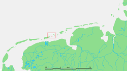 Location of Simonszand | |
| Geography | |
|---|---|
| Coordinates | 53°31′N 6°24′E |
| Archipelago | (West) Frisian Islands |
| Adjacent bodies of water | North Sea Wadden Sea |
| Administration | |
Netherlands | |
| Province | Groningen |
| Municipality | Het Hogeland |
| Demographics | |
| Population | Uninhabited |
The sandbank was originally mapped as being an Intertidal zone in approximately 1811, but changed in later mappings to be shown as a Supratidal zone after it became larger and migrated seaward.[1]
References
- van der Velde, L. (1995). "Geologica Ultraiectina". Geologica Ultraiectina. 125–126. ISBN 9789071577796.
External links
 Media related to Simonszand at Wikimedia Commons
| West Frisian Islands (Netherlands) |
|  | |||||
|---|---|---|---|---|---|---|---|
| East Frisian Islands (Germany) |
| ||||||
| Heligoland Bight (Germany) |
| ||||||
| North Frisian Islands (Germany) |
| ||||||
| Danish Wadden Sea Islands (Denmark) |
| ||||||
This Groningen location article is a stub. You can help Wikipedia by expanding it. |
На других языках
[de] Simonszand
Die kleine unbewohnte Düneninsel Simonszand (friesisch: Simenssân) liegt im Wattenmeer zwischen Schiermonnikoog und Rottumerplaat. Sie gehört zur Gemeinde Het Hogeland.- [en] Simonszand
[es] Simonszand
Simonszand es un pequeño islote situado entre Schiermonnikoog y Rottumerplaat, en la cadena de islas Frisias.[fr] Simonszand
Simonszand est un large banc de sable de la mer des Wadden, situé entre Schiermonnikoog et Rottumerplaat, au nord des Pays-Bas. Elle fait partie des îles de la Frise Occidentale et est rattachée à la commune d'Het Hogeland.[it] Simonszand
Simonszand è un'isola dei Paesi Bassi situata nel Mare dei Wadden. Fa parte della municipalità di Het Hogeland nella provincia della Groninga. Geograficamente l'isola fa parte dell'Arcipelago delle Isole Frisone Occidentali situata nell'estremo nord-est del paese. L'isola è situata tra le isole di Schiermonnikoog e Rottumerplaat. L'isola è costituita da una striscia allungata di dune sabbiose di circa 1,5 km di lunghezza e 750 metri di larghezza. Sull'isola si possono trovare piccoli trampolieri (piovanello maggiore e diverse specie di charadrii), anatre e foche. Vista la peculiarità dell'ambiente è vietata la navigazione nelle acque circostanti e l'approdo sull'isola.[ru] Симонсзанд
Симонсзанд (нидерл. Simonszand) — маленький необитаемый остров, скорее бар, в Ваттовом море в составе Западно-Фризских островов. Административно принадлежит общине Хогеланд провинции Гронинген в Нидерландах. Географически располагается между островами Схирмонниког и Роттюмерплат.Текст в блоке "Читать" взят с сайта "Википедия" и доступен по лицензии Creative Commons Attribution-ShareAlike; в отдельных случаях могут действовать дополнительные условия.
Другой контент может иметь иную лицензию. Перед использованием материалов сайта WikiSort.org внимательно изучите правила лицензирования конкретных элементов наполнения сайта.
Другой контент может иметь иную лицензию. Перед использованием материалов сайта WikiSort.org внимательно изучите правила лицензирования конкретных элементов наполнения сайта.
2019-2026
WikiSort.org - проект по пересортировке и дополнению контента Википедии
WikiSort.org - проект по пересортировке и дополнению контента Википедии