geo.wikisort.org - Island
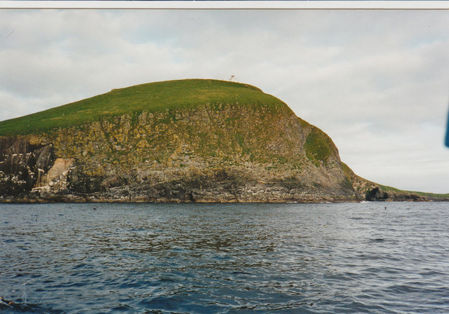
Rona[6] (Scottish Gaelic: Rònaigh) is a remote, uninhabited Scottish island in the North Atlantic. Rona is often referred to as North Rona to distinguish it from South Rona (another small island, in the Inner Hebrides). It has an area of 109 hectares (270 acres) and a maximum elevation of 108 metres (354 ft).[2][4][lower-alpha 1] It is included within the historic county of Ross-shire.
| Scottish Gaelic name | Rònaigh |
|---|---|
| Pronunciation | [ˈrˠɔːnaj] ( |
| Old Norse name | hraun-øy? |
| Meaning of name | possibly "seal island" |
| Location | |
 Rona Rona shown within Scotland | |
| OS grid reference | HW811323 |
| Coordinates | 59.12°N 5.82°W |
| Physical geography | |
| Island group | North Atlantic |
| Area | 109 ha (270 acres) |
| Area rank | 145 [1] |
| Highest elevation | Tobha Rònaigh, 108 m (354 ft)[2] |
| Administration | |
| Sovereign state | United Kingdom |
| Country | Scotland |
| Council area | Comhairle nan Eilean Siar |
| Demographics | |
| Population | 0 |
| References | [3][4] |
| North Rona Lighthouse | |
 North Rona | |
| Constructed | 1984 |
| Construction | masonry building |
| Automated | 1984 |
| Height | 13 m (43 ft) |
| Shape | parallelepiped building with lantern on the roof |
| Markings | white building |
| Power source | solar power |
| Operator | Rona and Sula Sgeir National Nature Reserve[5] |
| Focal height | 114 m (374 ft) |
| Range | 22 nmi (41 km; 25 mi) |
| Characteristic | Fl (3) W 20 s |
The island lies 71 kilometres (38+1⁄2 nautical miles) northwest of Cape Wrath, the same distance north-northeast of the Butt of Lewis and 18 km (9+1⁄2 nmi) east of Sula Sgeir. More isolated than St Kilda, it is the most remote island in the British Isles ever to have been inhabited on a long-term basis. It is also the closest neighbour to the Faroe Islands. Because of the island's remote location and small area, it is omitted from many maps of the United Kingdom.
Etymology
The name "Rona" may come from hraun-øy, Old Norse for "rough island", a combination of ròn and øy, Gaelic and Old Norse for "seal" and "island" respectively, or it may have been named after Saint Ronan.[4] The English language qualifier North is sometimes used to distinguish the island from Rona off Skye. In Gaelic it is also known as Rònaigh an Daimh which is literally 'Rona of the stag' but may be derived from Rònaigh an Taibh, containing the Norse word tabh, meaning "ocean" and convey the meaning "Rona of the Atlantic".[8]
History
Rona is said to have been the residence of Saint Ronan in the eighth century and he is said to have been the first inhabitant.[9] A tiny early Christian oratory which may be as early as this date, built of unmortared stone, survives virtually complete on the island – the best-preserved structure of this type in Scotland. A number of simple cross-slabs of early medieval date are preserved within the structure, probably the grave-markers of Dark Age monks or hermits from Scotland or Ireland. The island continued to be inhabited until the entire population of thirty died shortly after 1685 after an infestation by rats, probably the black rat (Rattus rattus), which reached the island after a shipwreck. The rats raided the food stocks of barley meal and it is possible the inhabitants starved to death, although plague may have been a contributory factor. This occurred in a year in which it is reported that no further ships reached the isolated island to supply or trade. The rats themselves eventually starved to death, the huge swells the island experiences preventing their hunting along the rocky shores.[10]
It was resettled, but again depopulated by around 1695 in some sort of boating tragedy, after which it remained home to a succession of shepherds and their families. It had a population of nine in 1764.[11]
"On one occasion ... a crew from Ness in Lewis had their boat wrecked in landing at Sula Sgeir in the month of June, and lived on the island for several weeks, sustaining themselves on the flesh of birds. Captain Oliver, who commanded the Revenue cruiser Prince of Wales, visited Sula Sgeir in the month of August to look for the lost boat. He found the wreck of it, also an oar on end with an old pair of canvas trousers on it, and over the remains of a fire a pot containing birds' flesh; but there being no trace of the men, it was thought they must have been picked up by a passing vessel. Nothing more was heard of them until the month of October following, when a Russian vessel on her homeward voyage met a Stornoway craft in the Orkney Islands and informed the crew of the latter that they had taken the men off Sula Sgeir and landed them in Rona. Captain Oliver at once went to Rona, and found the crew consuming the last barrel of potatoes which the poor shepherd had. He took away the former and left the latter sufficient provision for the winter."[12] Captain Benjamin Oliver commanded the vessel from 1811 until 1847.[13]
"The last family which lived upon Rona was that of a shepherd named Donald M'Leod, otherwise the 'King of Rona,' who returned to Lewis in 1844."[14] Sir James Matheson, who bought Lewis in 1844, offered the island to the Government for use as a penal settlement. The offer was refused.
Although farmers from Lewis have continued to graze sheep on Rona ever since, the island has remained uninhabited, apart from one brief and tragic episode in 1884–85. In June 1884, two men from Lewis, Malcolm MacDonald and Murdo Mackay, having reportedly had a dispute with the minister of their local church, went to stay on Rona to look after the sheep. In August, boatmen who had called at the island reported that the men were well and in good spirits, and had refused offers to take them back to Lewis. In April 1885, the next people to visit Rona found the two men had died during the winter.
During World War I, the commander of German U-boat U-90, Walter Remy, stopped his submarine at North Rona during each of his wartime patrols, weather permitting, and sent crewmen onto the island to shoot sheep to obtain mutton for on-board consumption.[15]
The island was occupied temporarily in 1938–1939 by author and conservationist Frank Fraser Darling with his wife Bobbie and their son Alasdair, while they studied the grey seals and the breeding seabirds.
North Rona, with Sula Sgeir, historically formed part of the Barvas estate on Lewis, but a community buy-out of the estate in 2016 did not include the two islands, which would apparently have increased the purchase price by £80,000.[16]
The island still boasts the Celtic ruins of St Ronan's Chapel. Together with Sula Sgeir, the island was formerly managed by Scottish Natural Heritage as a nature reserve, for its important grey seal and seabird colonies. These include the European storm-petrel and the larger Leach's storm-petrel, for which North Rona is an important breeding locality. It remains a protected area for nature and is a Site of Special Scientific Interest and a Special Protection Area.
In "Island at the edge of the world", the poet Kathleen Jamie describes a visit to the island,[17] as well as in an essay in her collection Sightlines.
The island hosts an automatic light beacon, remotely monitored by the Northern Lighthouse Board.[2]
See also
- List of islands in Scotland
- List of lighthouses in Scotland
- List of Northern Lighthouse Board lighthouses
- List of outlying islands of Scotland
Gallery
![Ronay Island.[18]](//upload.wikimedia.org/wikipedia/commons/thumb/5/59/Ronay_island.jpg/87px-Ronay_island.jpg) Ronay Island.[18]
Ronay Island.[18]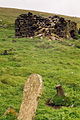 The Remains of St Ronan's Church, Rona - geograph.org.uk - 91788
![Ronay Island.[18]](http://upload.wikimedia.org/wikipedia/commons/5/59/Ronay_island.jpg)

Footnotes
- Boyd (1986) gives the height as 116 metres (381 feet) and the area as 120 acres (49 hectares).[7]
References
- Area and population ranks: there are c. 300 islands over 20 ha in extent and 93 permanently inhabited islands were listed in the 2011 census.
- Gittings 2012.
- General Register Office for Scotland (28 November 2003) Scotland's Census 2001 – Occasional Paper No 10: Statistics for Inhabited Islands. Retrieved 26 February 2012.
- Haswell-Smith 2004, pp. 326–329.
- Rowlett, Russ. "Lighthouses of Scotland: Western Isles". The Lighthouse Directory. University of North Carolina at Chapel Hill. Retrieved 16 May 2016.
- "Rona/Rònaidh". Ordnance Survey. Retrieved 19 October 2019.
- Boyd 1986, p. 119.
- Mac an Tàilleir 2003, p. 92.
- Macfarlane, Robert (2013). The Old Ways. London: Penguin Books. p. 121. ISBN 978-0-141-03058-6.
- Fraser Darling & Boyd 1969, pp. 73–74.
- Walker, John, An economical history of the Hebrides and highlands of Scotland 1812, Vol I, page 23
- Swinburne 1883, p. 55.
- Stornoway Historical Society - Captain Benjamin Oliver
- Swinburne 1883, p. 63.
- Gleaves 1921, p. 219.
- David Kerr, Community buy £700,000 Western Isles estate, Press and Journal, 17 April 2016
- Island at the edge of the world
- Harvie-Brown, J. A. & Buckley, T. E. (1889), A Vertebrate Fauna of the Outer Hebrides. Pub. David Douiglas, Edinburgh. Facing P. XXXVI.
Modern sources
- Atkinson, Robert (1949). Island Going. Collins. ISBN 9781841587127.
- Boyd, John Morton (1986). Fraser Darling's Islands. Edinburgh University Press. ISBN 0-85224-514-9.
- Fraser Darling, Frank (1939). A Naturalist on Rona: essays of a biologist in isolation. Oxford: Clarendon Press. ISBN 9780527214005.
- Fraser Darling, Frank (1940). Island Years. G. Bell & Sons. ISBN 9780330234672.
- Fraser Darling, Frank; Boyd, John Morton (1969). Natural History in the Highlands and Islands. London: Bloomsbury.
- Gittings, B.M. (2012). "Rona (North Rona; Ronaidh)". Gazetteer for Scotland. Retrieved 5 June 2017.
- Gleaves, Albert (1921). A History of the Transport Service: Adventures and Experiences of United States Transports and Cruisers in the World War. New York: George H. Doran Company. OCLC 976757.
- Haswell-Smith, Hamish (2004). The Scottish Islands. Edinburgh: Canongate. ISBN 978-1-84195-454-7.
- Mac an Tàilleir, Iain (2003) Ainmean-àite/Placenames. (pdf) Pàrlamaid na h-Alba. Retrieved 26 August 2012.
- Nisbet, HC; Gailey, RA (1962). "A survey of the antiquities of North Rona" (PDF). Archaeological Journal. Royal Archaeological Institute. 117: 88–115. doi:10.1080/00665983.1960.10854159. Retrieved 2 April 2016.
- Robson, Michael (1991). Rona, the Distant Island. Acair. ISBN 9780861528233.
- Robson, Michael (2006). A Sad Tale of the Sea: The Story of Malcolm MacDonald and Murdo MacKay on the Island of Rona. Isle of Lewis. ISBN 9780953401543.
Pre-1900 sources
- Harvie-Brown, J. A. (1887). "XXI, Further Notes on North Rona, being an Appendix to Mr. John Swinburne's Paper on that Island in the "Proceedings" of this Society, 1883-84". Proceedings of the Royal Physical Society of Edinburgh. 9. 1885-8: 284. Retrieved 2 April 2016. - Contains information about Malcolm MacDonald and Murdoch Mackay.
- "The Scottish Islands—Deaths in the Island of Rona". Parliamentary Debates (Hansard). Vol. 297. House of Commons. 5 May 1885. col. 1631–1632.
- Macculloch, John (1819), A Description of the Western Islands of Scotland, Including the Isle of Man, Constable
- Macculloch, John (1824), The highlands and western isles of Scotland, in letters to Sir Walter Scott, Longman
- Mackenzie of Tarbat, George (1681–1684), Account of Hirta and Rona, Misc. Scotica, vol. 2, p. 29 in Geographical Collections Relating to Scotland made by Walter Macfarlane, vol. 3 (account given to Sir Robert Sibbald
- Martin, Martin (1703), A Description of the Western Islands of Scotland, Andrew Bell, at the Cross-Keys and Bible, in Cornhil, near Stocks-Market., pp. 19ff (Describes the swarm of rats on pages 24–5).
- Morrison, John, Indweller (c. 1683), A Descriptione of the Lews, archived from the original on 16 April 2016, retrieved 2 April 2016
- Munro, Donald (1563), Description of the Western Isles of Scotland, called Hybrides, T.D. Morison, p. 62
- MacDonald, Donald (1791–99), "Barvas, County of Ross and Cromarty" (PDF), The Old Statistical Account of 1791-99, vol. 19, p. 271 (Google Books page 286/671)
- Swinburne, John (1883). "II, Notes on the Islands of Sula Sgeir, or North Barra and North Rona, with a List of the Birds Inhabiting them". Proceedings of the Royal Physical Society of Edinburgh. 8: 51. Retrieved 6 April 2016.
- "Deaths On A Scotch Island". Times. London. 25 April 1885. p. 11. Retrieved 12 April 2016.
- "The deaths at Rona". Times. London. 29 May 1885. p. 7. Retrieved 12 April 2016.
External links
- BBC Radio 3 Feature on North Rona
- Historic Environment Scotland. "St Ronan's Church & village settlement,Rona (SM1683)".
- Joint Nature Conservation Committee - North Rona - Special Area of Conservation
- Royal Commission on the Ancient and Historical Monuments of Scotland - Information on the church and oratory
- Scotland's National Nature Reserves - Rona and Sula Sgeir
- Charles Tait Photographs of North Rona
- Article in the Herald Scotland - 13 July 2002
- Northern Lighthouse Board
| Inhabited islands | ||
|---|---|---|
| Other islands | ||
| Settlements |
| |
| Districts | ||
| Geographical features |
| |
| Historical sites |
| |
Inhabited islands of the Hebrides | ||
|---|---|---|
| Inner Hebrides |  | |
| Outer Hebrides | ||
| Authority control |
|
|---|
На других языках
[de] North Rona
Rona (schottisch-gälisch: Rònaigh;, früher auch Ronay, auch North Rona) ist eine Insel der Äußeren Hebriden in Schottland. Den Zusatz North trägt sie zur Unterscheidung von South Rona, das zu den Inneren Hebriden gehört. Rona ist von allen britischen Inseln die abgelegenste Insel, die permanent bewohnt war.- [en] North Rona
[fr] North Rona
Rona, souvent appelé North Rona est une île du Royaume-Uni située en Écosse dans l'Atlantique nord. Sa superficie est de 109 hectares pour une altitude maximum de 108 mètres.[it] North Rona
North Rona (nella Lingua gaelica scozzese Rònaigh) è una remota e disabitata isola scozzese nell'Oceano Atlantico settentrionale. Rona è spesso citata come North Rona per distinguerla da South Rona un'altra piccola isola sita nelle Ebridi Interne. L'isola occupa un'area di 109 ettari (pari a 270 acri) e l'altezza massina è di 108 metri sul livello del mare (354 piedi)[1][2][3].[ru] Рона (Шотландия, северная)
Ро́на[1] (англ. Rona, гэльск. Rònaigh, [rˠɔːnaj]) — изолированный остров в Северной Атлантике[1]. Также известен как Северная Рона, чтобы отличить от Южной Роны во Внутренних Гебридах. Ближайшая суша — Сулискер (18 км на запад), Льюис (71 км на ЮЮЗ), мыс Рат (основная часть Шотландии, 72 км на юго-восток), Стак-Скерри (75 км на восток), Судурой (Фареры, 255 км на север). Несмотря на бо́льшую изолированность, чем даже на Сент-Килде, долго был обитаем. Ввиду малых размеров и изолированности не помечен на многих картах Великобритании.Другой контент может иметь иную лицензию. Перед использованием материалов сайта WikiSort.org внимательно изучите правила лицензирования конкретных элементов наполнения сайта.
WikiSort.org - проект по пересортировке и дополнению контента Википедии