geo.wikisort.org - Island
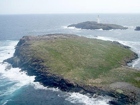
Bound Skerry is part of the Out Skerries group in the Shetland Islands. As well as being the most easterly island of that group, it is also the easternmost point of Scotland.
| Location | |
|---|---|
 Bound Skerry Bound Skerry shown within Scotland | |
| OS grid reference | HU702719 |
| Coordinates | 60.424°N 0.728°W |
| Physical geography | |
| Island group | Out Skerries Shetland |
| Area | 0.05 km |
| Administration | |
| Sovereign state | United Kingdom |
| Country | Scotland |
| Council area | Shetland Islands |
| Demographics | |
| Population | 0 |
| References | [1][2] |
| Bound Skerry Lighthouse | |
 Bound Skerry Lighthouse in 2009 | |
| Constructed | 1858 |
| Built by | David Stevenson, Thomas Stevenson |
| Construction | stone |
| Automated | 7 April 1972 |
| Height | 30 m (98 ft) |
| Shape | cylindrical tower with balcony and lantern |
| Markings | white (tower), black (lantern), ochre (trim) |
| Operator | Northern Lighthouse Board |
| Heritage | category B listed building |
| Focal height | 44 m (144 ft) |
| Intensity | 159,000 candela |
| Range | 20 nmi (37 km; 23 mi) |
| Characteristic | Fl W 20s |
It has a lighthouse on it, which was built in 1857 at a cost of £21,000.[3][4] Robert Louis Stevenson's family were lighthouse builders, and his signature can be seen in its guestbook.[1] The keepers lived on nearby Grunay.
The island was bombed twice in World War II by the German Luftwaffe, because it was suspected to harbour a munitions factory.[1]
See also
- List of lighthouses in Scotland
- List of Northern Lighthouse Board lighthouses
References
- Haswell-Smith, Hamish (2004). The Scottish Islands. Edinburgh: Canongate. ISBN 978-1-84195-454-7.
- Ordnance Survey. OS Maps Online (Map). 1:25,000. Leisure.
- Rowlett, Russ. "Lighthouses of Scotland: Shetland". The Lighthouse Directory. University of North Carolina at Chapel Hill. Retrieved 29 May 2016.
- Out Skerries Northern Lighthouse Board. Retrieved 29 May 2016
External links
Wikimedia Commons has media related to Bound Skerry.
Shetland | ||
|---|---|---|
| Inhabited islands | ||
| Other islands | ||
| Towns and villages | ||
| Mainland Parishes |
| |
| Insular Parishes | ||
| Maritime features |
| |
Extreme points
| ||
| Topics |
| |
This British lighthouse-related article is a stub. You can help Wikipedia by expanding it. |
This Shetland location article is a stub. You can help Wikipedia by expanding it. |
На других языках
[de] Bound Skerry
Bound Skerry ist eine unbewohnte Insel im Osten der Out Skerries, einer Inselgruppe, die zu den Shetlands zählt. Sie markiert zugleich den östlichsten Punkt Schottlands, Zu Bound Skerry gehören zwei Halbinseln, Tamma Skerry im Süden sowie Little Bound Skerry im Nordwesten. Auf der Insel steht das Out Skerries Lighthouse, ein 1858 fertiggestellter Leuchtturm, der seit 1971 als Listed Building der Kategorie B ausgewiesen ist und somit unter Denkmalschutz steht.[1] Bis zu dessen Automatisierung 1972[2] lebten die Wärter des Turms auf der wenig südwestlich gelegenen Insel Grunay.[3]- [en] Bound Skerry
[fr] Bound Skerry
Bound Skerry est une île faisant partie de l'archipel des Skerries extérieures, situé dans les Shetland, en Écosse.Текст в блоке "Читать" взят с сайта "Википедия" и доступен по лицензии Creative Commons Attribution-ShareAlike; в отдельных случаях могут действовать дополнительные условия.
Другой контент может иметь иную лицензию. Перед использованием материалов сайта WikiSort.org внимательно изучите правила лицензирования конкретных элементов наполнения сайта.
Другой контент может иметь иную лицензию. Перед использованием материалов сайта WikiSort.org внимательно изучите правила лицензирования конкретных элементов наполнения сайта.
2019-2026
WikiSort.org - проект по пересортировке и дополнению контента Википедии
WikiSort.org - проект по пересортировке и дополнению контента Википедии