geo.wikisort.org - Island
Bressay (Scots: Bressa) is a populated island in the Shetland archipelago of Scotland.
| Scots name | Bressa[1] |
|---|---|
| Old Norse name | Breiðey/Brusey |
| Meaning of name | Old Norse for 'broad island' or 'Brusi's island' |
 Bressay Lighthouse at Kirkabister Ness overlooking Bressay Sound | |
| Location | |
 Bressay Bressay shown within the Shetland Islands | |
| OS grid reference | HU507406 |
| Coordinates | 60.15°N 1.08°W |
| Physical geography | |
| Island group | Shetland |
| Area | 2,805 ha (10+7⁄8 sq mi) |
| Area rank | 30 [2] |
| Highest elevation | Ward of Bressay, 226 m (741 ft) |
| Administration | |
| Sovereign state | United Kingdom |
| Country | Scotland |
| Council area | Shetland Islands |
| Demographics | |
| Population | 368[3] |
| Population rank | 25 [2] |
| Population density | 13/km2 (34/sq mi)[3][4] |
| Largest settlement | Maryfield |
| References | [4][5][6] |
Geography and geology
Bressay lies due south of Whalsay, west of the Isle of Noss, and north of Mousa. With an area of 11 square miles (28 km2), it is the fifth-largest island in Shetland. The population is around 360 people,[3] concentrated in the middle of the west coast, around Glebe and Fullaburn.
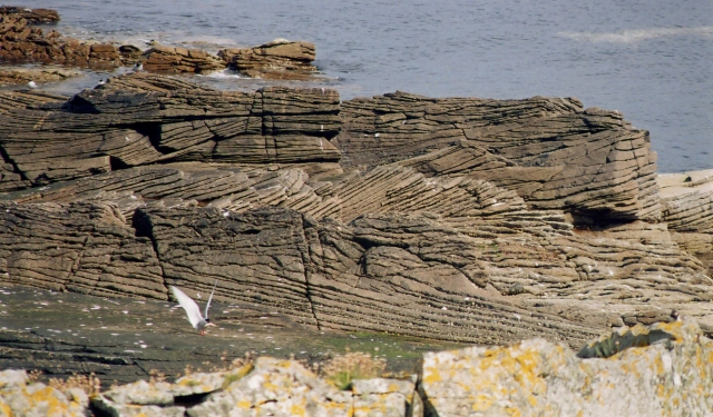
The island is made up of Old Red Sandstone with some basaltic intrusions. Bressay was quarried extensively for building materials, used all over Shetland, especially in nearby Lerwick.[4] There are a number of sea caves and arches. The largest of eleven lochs on the island are the Loch of Grimsetter in the east, and the Loch of Brough.
Wildlife
Bressay has a large number of migrant birds, especially in the east. The Loch of Grimsetter is a haven for waders and whooper swans. In the far south, there is a colony of Arctic skuas.[4]
History
The name of the island may have been recorded in 1263 as 'Breiðoy' (Old Norse "broad island"). In a 1490 document the island is referred to as "Brwsøy" - "Brusi's island" which name may indicate it was the 11th century base for Earl of Orkney Brusi Sigurdsson.[7][4] This possibility is supported by a later reference to his son Rögnvald as "Lord of the Shetlanders" and Thompson (2008) is in "no doubt " that Shetland specifically was in Brusi's possession during his joint earldom with his brothers.[8][9]
The Bressay Stone is an outstanding example of Pictish art.
- a slab of chlorite slate, about 16 inches [400 mm] wide at the top, tapering to less than a foot [300 mm] at the bottom.[6]
The slender sides are engraved with ogham, and the two faces with various examples of knotwork, and imagery. The top of each face has a cross. On one side, there is an engraving of two men with crosiers, as well as various animals including horses, pigs, and what appears to be someone in the process of being swallowed by two sea monsters. It has been suggested that this is Jonah.[6]
During World War I and II gun emplacements were built to guard Bressay Sound.
Infrastructure
Attractions on the island include Bressay Lighthouse. At Maryfield there is a heritage centre, a hotel and the old laird's mansion, Gardie House, built in 1724. The Northern Lights Spa Hotel at Uphouse is Britain's most northerly spa.[10][11]
Frequent car ferries sail from Maryfield to Lerwick on the Shetland Mainland. During the summer months, a passenger ferry service links the east coast of Bressay with the nature reserve Isle of Noss.
Lerwick and Bressay Parish Church (of the Church of Scotland) has three places of worship. The Bressay Church building is located close to the Marina, near the centre of the west coast of the island.
Gallery
- Images of Bressay
 Full-rigged ship Maella, of Oslo, in Bressay Sound circa 1922
 Cross-bedding in Middle Old Red Sandstone on Bressay
 Loch of Setter
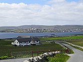 View of Lerwick from Bressay
 A replica of the Pictish Bressay Stone in St Mary's churchyard where the original stone was found.


See also
- List of islands of Scotland
- Bressay transmitting station
Notes
- "Map of Scotland in Scots - Guide and gazetteer" (PDF).
- Area and population ranks: there are c. 300 islands over 20 ha in extent and 93 permanently inhabited islands were listed in the 2011 census.
- National Records of Scotland (15 August 2013). "Appendix 2: Population and households on Scotland's Inhabited Islands" (PDF). Statistical Bulletin: 2011 Census: First Results on Population and Household Estimates for Scotland Release 1C (Part Two) (PDF) (Report). SG/2013/126. Retrieved 14 August 2020.
- Haswell-Smith (2004), pp. 425–429
- Ordnance Survey. OS Maps Online (Map). 1:25,000. Leisure.
- Anderson, Joseph (Ed.) (1893) Orkneyinga Saga. Translated by Jón A. Hjaltalin & Gilbert Goudie. Edinburgh. James Thin and Mercat Press (1990 reprint). ISBN 0-901824-25-9
- Smith (1988), p. 27
- Smith (1988), p. 21
- Thomson (2008), pp. 70–73
- "bressay". Visit Shetland. Retrieved 1 March 2013.
- Visit Scotland - Northern Lights Spa Hotel Archived 2011-07-18 at the Wayback Machine Retrieved 30 June 2007.
References
- Haswell-Smith, Hamish (2004). The Scottish Islands. Edinburgh: Canongate. ISBN 978-1-84195-454-7.
- Smith, Brian (1988), "Shetland in Saga-Time: Re-reading the Orkneyinga Saga", Northern Studies, Edinburgh: Scottish Society for Northern Studies, 25: 21–41
- Thomson, William P. L. (2008), The New History of Orkney, Edinburgh: Birlinn, ISBN 978-1-84158-696-0
External links
- Cullingsbrough, bressay-history-group.org. Archived on March 2, 2012.
- Cullingsburgh (Culbinsburgh, Culbinsgarth), geos.ed.ac.uk.
- Papil Geo, Isle of Noss, Bressay, paparproject.org.uk
| Inhabited islands | ||
|---|---|---|
| Other islands | ||
| Towns and villages | ||
| Mainland Parishes |
| |
| Insular Parishes | ||
| Maritime features |
| |
Extreme points
| ||
| Topics |
| |
|  | ||||||||||||||||
|
| |||||||||||||||||
| |||||||||||||||||
| |||||||||||||||||
| |||||||||||||||||
| |||||||||||||||||
| |||||||||||||||||
| |||||||||||||||||
| Authority control |
|
|---|
На других языках
[de] Bressay
Die schottische Insel Bressay gehört zur Gruppe der Shetlandinseln und liegt, durch den Bressay Sund getrennt, nur wenige hundert Meter östlich der Hauptinsel Mainland. Nach Lerwick, dem Hauptort der Inselgruppe besteht eine regelmäßige Fährverbindung über die Leirna, die wenige Minuten in Anspruch nimmt.- [en] Bressay
[fr] Bressay
Bressay est une île du Royaume-Uni située en Écosse, dans l'archipel des Shetland, en face de Lerwick[1], la capitale du comté et du council area des Shetland. Malgré sa proximité avec une petite ville de près de 7 000 habitants[3], elle reste encore rurale et peu peuplée avec moins de 400 habitants[4],[2].[it] Bressay
Bressay è un'isola sull'oceano Atlantico della Scozia nord-orientale, facente parte dell'arcipelago delle Shetland. Conta una popolazione di circa 350 abitanti e si estende per 10,8 km².[1][ru] Брессей
Бре́ссей (англ. Bressay) — остров в архипелаге Шетландских островов на севере Шотландии.Другой контент может иметь иную лицензию. Перед использованием материалов сайта WikiSort.org внимательно изучите правила лицензирования конкретных элементов наполнения сайта.
WikiSort.org - проект по пересортировке и дополнению контента Википедии