geo.wikisort.org - Island
The freshwater islands in Scotland include those within freshwater lochs and rivers – including tidal areas, so the islands may not always be surrounded by freshwater. It has been estimated that there are at least 31,460 freshwater lochs in Scotland and that 1.9 per cent of the land surface is covered by freshwater. The distribution has a north-west to south-east gradient, with the highest concentrations occurring on the islands of the Outer Hebrides.[2][Note 1]
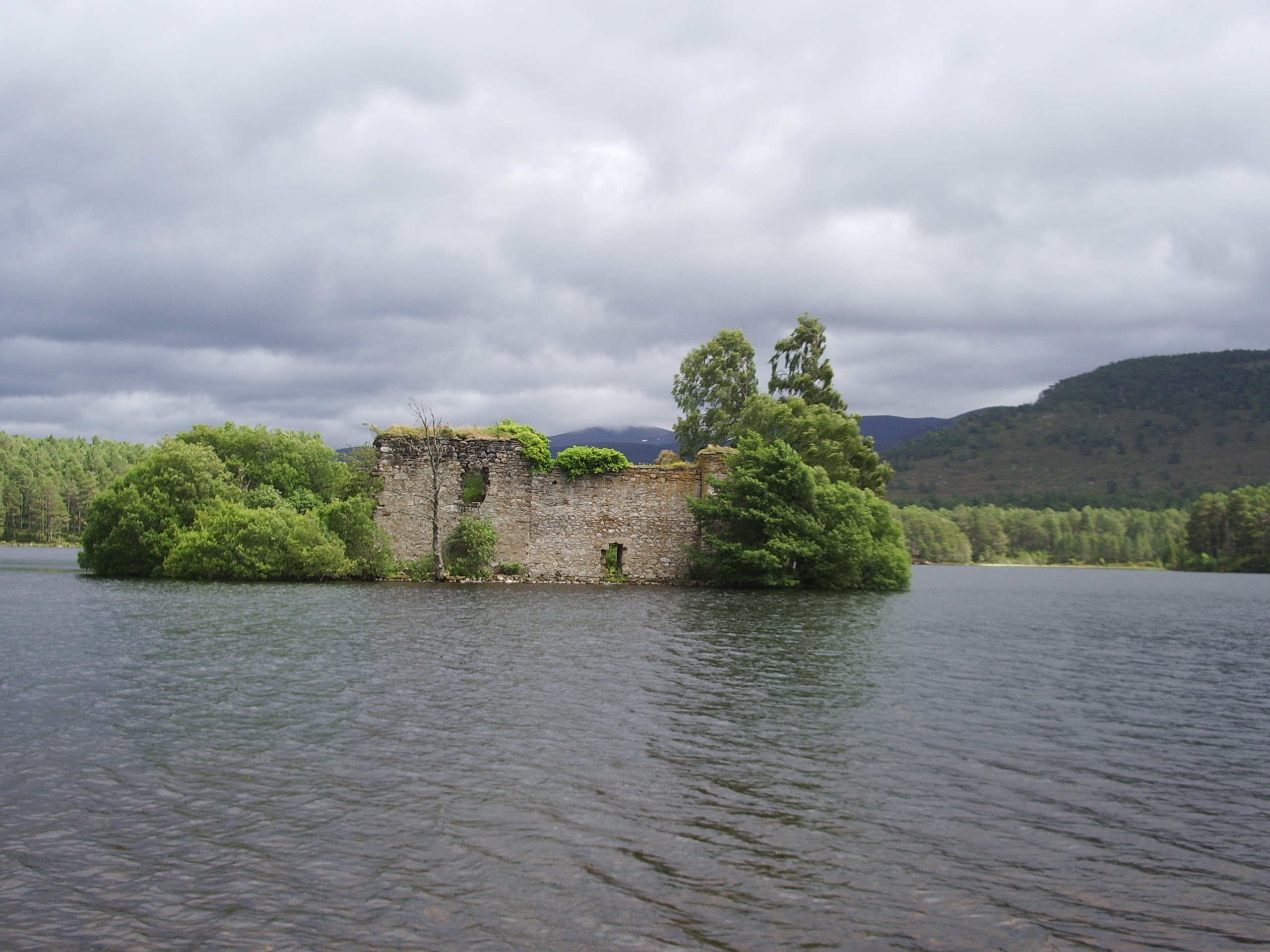
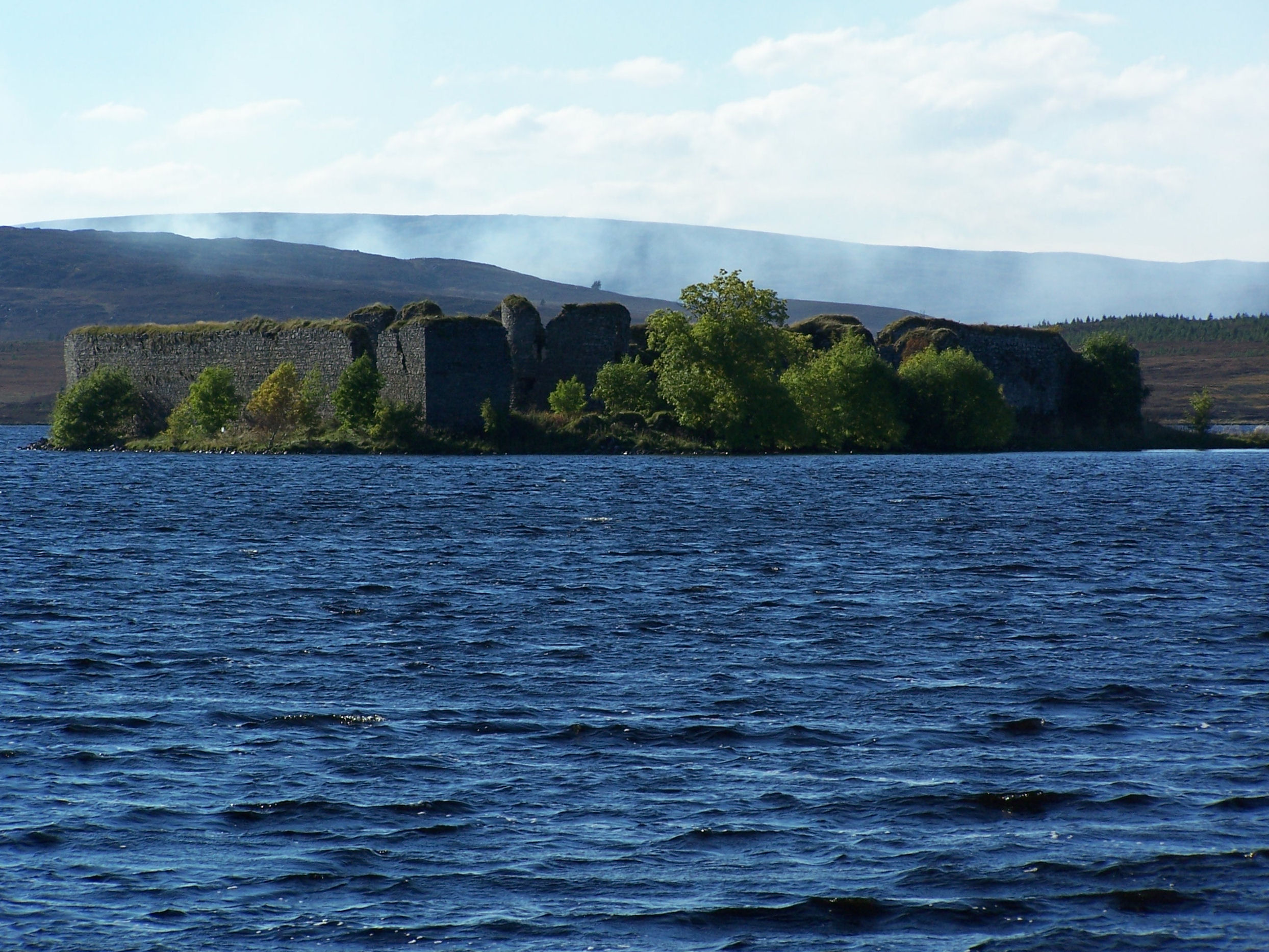
![Loch Leven Castle island, where Mary, Queen of Scots, was imprisoned in 1567.[1]](http://upload.wikimedia.org/wikipedia/commons/6/66/Lochlevencastle.jpg)
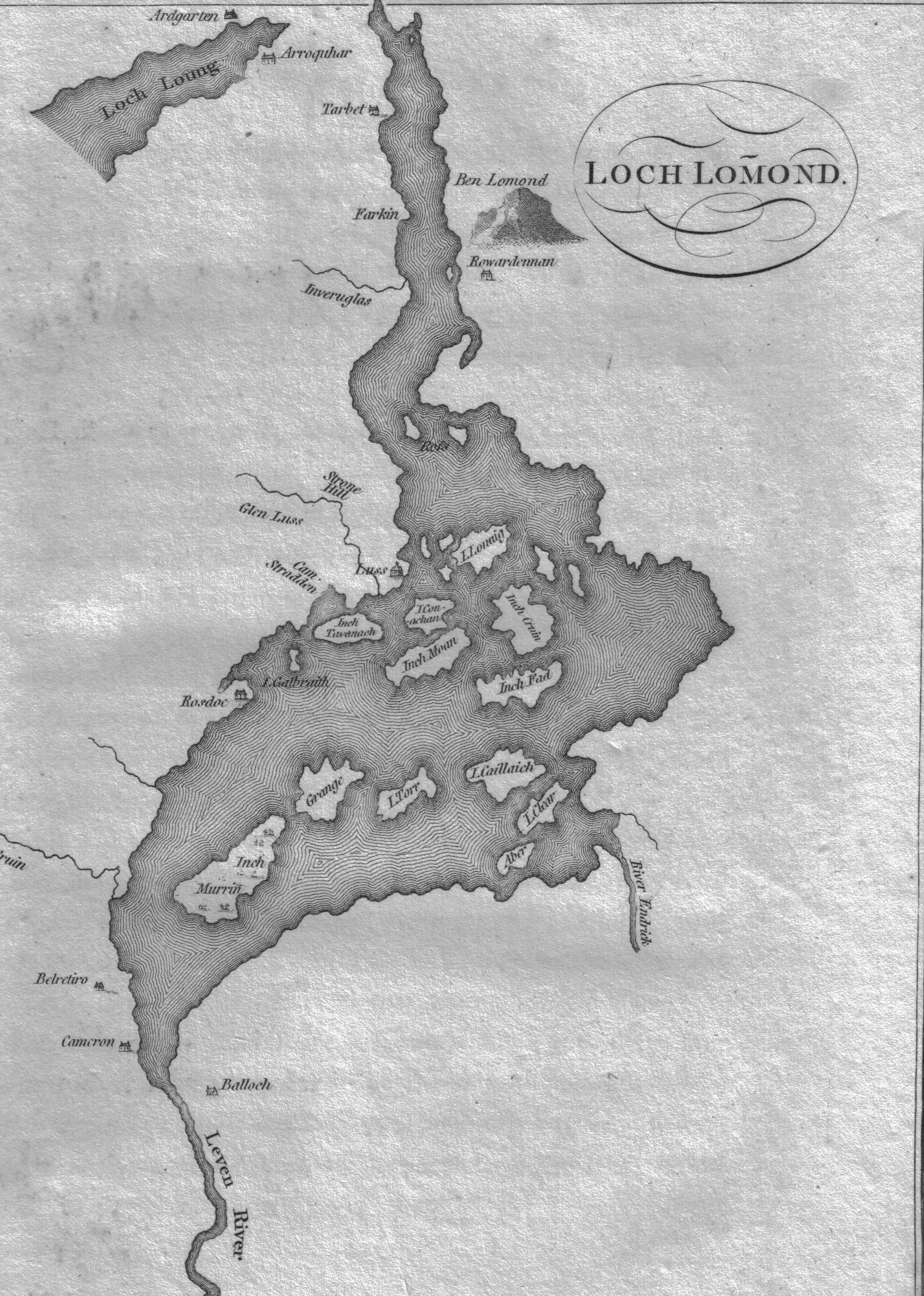
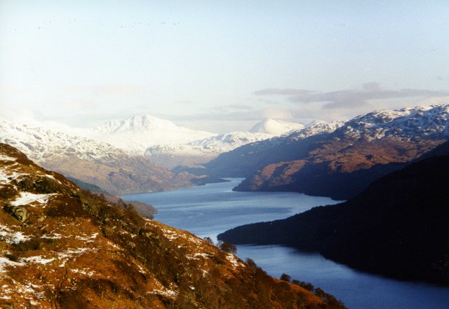
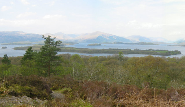
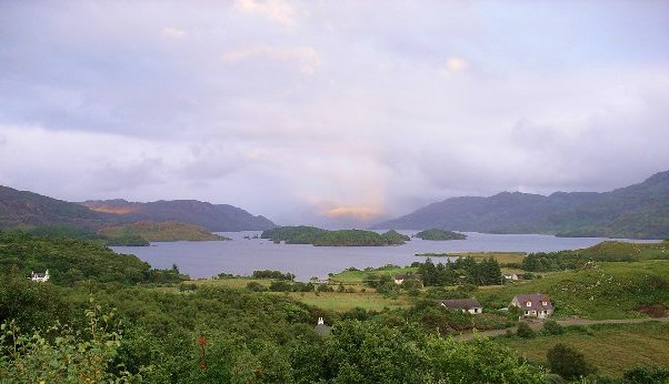
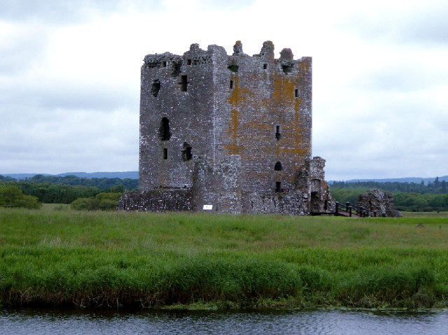
The more notable freshwater islands include Lochindorb Castle Island, Loch Leven Castle Island, St Serf's Inch and Inchmahome, each of which have had a role to play in Scottish history.[1][4][5][6] Inchmurrin, the largest freshwater island in the British Isles, is in Loch Lomond, which contains thirty or more other islands.[7][Note 2]
Various names are used repeatedly. "Inch" or Innis is a Scots word that can mean 'island' (although it is also used for terra firma surrounded by marsh). Similarly, Eilean is the Gaelic for 'island'. A common suffix for offshore islands in the north of Scotland is "-holm", derived from the Old Norse holmr, meaning a 'small and rounded islet'.[12][13][14] This list excludes artificial crannógs and the numerous small freshwater islands with no recorded name.[Note 3][Note 4]
Larger islands


This table includes all of the freshwater islands that exceed 35 hectares (86 acres) in size and/or are populated.
| Island | Location | Area[16] | Population[17] |
|---|---|---|---|
| Dunglass Island | River Conon | 40 ha (99 acres) | 0 |
| Eilean Mòr | Loch Langavat | 59 ha (150 acres) | 0 |
| Eilean Ruairidh Mòr | Loch Maree | 38 ha (94 acres)[18] | 0 |
| Eilean Sùbhainn | Loch Maree | 118 ha (290 acres) | 0 |
| Garbh Eilean | Loch Maree | 39 ha (96 acres)[18] | 0 |
| Inchcailloch | Loch Lomond | 50 ha (120 acres)[18] | 0 |
| Inchconnachan | Loch Lomond | 35 ha (86 acres)[18] | 0 |
| Inchfad | Loch Lomond | 35 ha (86 acres)[18] | 1 |
| Inchlonaig | Loch Lomond | 80 ha (200 acres)[18] | 0 |
| Inchmurrin | Loch Lomond | 120 ha (300 acres)[18] | 8 |
| Inchtavannach | Loch Lomond | 70 ha (170 acres)[18] | 3 |
| Innis Chonan | Loch Awe | 8 ha (20 acres) | 5 |
| Contin Island | Black Water | 15 ha (37 acres) | 3 |
| Inverness Central Island | River Ness/Caledonian Canal | 370 ha (915 acres) | ~15,000 |
| Moncreiffe Island | River Tay | 46 ha (110 acres) | 3 |
| St Serf's Inch | Loch Leven | 31 ha (77 acres)[18] | 0 |
Inchlonaig and Inchcruin[Note 5] are classified by the National Records of Scotland as "inhabited islands but had no usual residents at the time of either the 2001 or 2011 censuses."[17] It is likely that Eilean Aigas is inhabited, at least from time to time as well, although it was not listed as such by the Census in 2001[19] or 2011.[citation needed]
In mainland lochs


Loch Awe is Scotland's longest loch and abounds with islands and crannógs. Several of the islands are, or have in the past, been inhabited; there are two castles and the remains of a chapel on the islands.[20] Inistrynich, Eilean na Maodail, Eilean Dubh and Liever Island are all promontories as opposed to islands despite their names. The loch's water levels have fluctuated so some of them may have been islands in recent history, as the promontory on which Kilchurn Castle stands once was.[21]
There may be up to sixty islands in the Loch Lomond including Inchmurrin, the largest freshwater island anywhere in the Britain and Ireland, and Inchconnachan, which has hosted a small population of Red-necked Wallaby since at least 1975.[22][23] The isolated strongholds of Lochindorb Castle and Loch an Eilein Castle were once in the hands of the 14th century nobleman Alexander Stewart, the infamous "Wolf of Badenoch".[24][25] There are numerous unnamed small islands in mainland lochs, including those where the water level has been artificially raised by the creation of dams for the production of hydro-electricity. This process has created new islands that would previously have been small eminences.[citation needed][26]
| Local authority[Note 6] | Loch | OS Grid reference | Islands[Note 7] |
|---|---|---|---|
| Aberdeenshire | Loch of Strathbeg | NK067591 | Red Rock |
| Argyll and Bute | Loch Avich | NM928138 | Eilean Fraoch, Innis Luana |
| Argyll and Bute | Loch Awe | NN108253 | Badan Tomain, Black Islands, Eilean Beith, Eilean a' Chòmhraidh, Eilean a' Chrochaidh, Eilean an t-Sagairt (2), Eilean an t-Slinne, Eilean nam Meann, Eilean Seileachan, Fraoch Eilean, Innis Chonan, Innis Chonnel, Innis Errich, Innis Sèa-ràmhach, Innis Stiùire, Inishail |
| Argyll and Bute/Stirling/West Dunbartonshire | Loch Lomond | NS380911 | Aber Isle, Bucinch, Ceardach, Clairinsh, Creagan Dubha, Creinch, Eilean Deargannan, Eilean na h-Aon Chraoibhe, Ellanderroch, Fraoch Eilean, Inchcailloch, Inchconnachan, Inchcruin, Inchfad, Inchgalbraith, Inchlonaig, Inchmoan, Inchmurrin, Inchtavannach, Inveruglas Isle, Island I Vow, Keppinch, Stot Isle, Ross Isles, Tarbet Isle, Torrinch, Wallace's Isle |
| Ayrshire | Bogton Loch | NS470055 | Elizabeth Isle |
| Ayrshire | Loch Macaterick | NX440915 | Blaeberry Isle, Deer Isle, Eagles Isle |
| Badenoch and Strathspey | Loch an Eilein | NH900080 | Loch an Eilein Castle |
| Badenoch and Strathspey | Loch Insh | NH833052 | Tom Dubh |
| Dumfries and Galloway | Loch Kindar | NX970642 | Kirk Kindar Island |
| Dumfries and Galloway | Loch Ken | NX729652 | Burned Island, Corselands, Danevale Island, Green Island, Kenmure Holms, Parton Island, Parton Ward |
| Dumfries and Galloway | Loch Moan | NX350857 | Black Island, White Island |
| Dumfries and Galloway | Loch Trool | NX415800 | Maiden Isle, Ringielawn or the Soldiers' Holm |
| Dumfries and Galloway | Loch Urr | NX758847 | Rough Island |
| Inverness | Loch Moy | NH774345 | Eilean nan Clach, Isle of Moy |
| Lochaber | Loch Arkaig | NN161888 | An t-Eilean Beag, Eilean a' Ghiubhais, Eilean Loch Airceig |
| Lochaber | Loch Bà | NN322504 | Eilean Molach, Eilean na h-Iolaire |
| Lochaber | Loch Eilt | NM807821 | Eilean an Tighe, Eilean Gaineamhach, Eilean Mòr, Eilean na Moine, Eilean nan Corra-ghriodhach |
| Lochaber | Loch Morar | NM700917 | An t-Eilean Meadhoin, Brinacory Island, Eilean Allmha, Eilean a' Phidhir, Eilean Bàn, Eilean Ghibbi, Eilean nam Breac, Eilean nan Reithean |
| Lochaber | Loch Quoich | NH058011 | Rubha Dubh nam Fiad |
| Lochaber | Loch Shiel | NM904803 | Eilean Comlach, Eilean Drollaman, Eilean Dubh, Eilean Fhianain, Eilean Ghleann Fhionainn, Eilean Mhic Dhomhnuill Dhuibh, Seilag |
| Moray | Lochindorb | NH974361 | Lochindorb Castle island |
| Perth and Kinross | Loch Earn | NN690242 | Neish Island |
| Perth and Kinross | Loch Leven | NO144013 | Loch Leven Castle Island, St Serf's Inch |
| Perth and Kinross | Loch of Clunie | NO115444 | Clunie Castle Island |
| Perth and Kinross | Loch Tay | NN766452 | Isle of Spar |
| Perth and Kinross | Loch Tummel | NN852595 | An Dùn |
| Perth and Kinross/Lochaber | Loch Laidon | NN378542 | Eilean Iubhair |
| Ross and Cromarty | Fionn Loch | NG945803 | Eilean a' Garbh Uilt, Eilean an Eich Bhàin, Eilean Fraoich, Eilean nan Corrichean |
| Ross and Cromarty | Loch Maree | NG914730 | Eilean Camas a' Chonnaidh, Eilean nan Clachairean, Eilean a' Chlamhain, Eilean na Craoibhe, Eilean na Creige Giubhas, Eilean Dubh na Sròine, Eilean Eachainn, Eilean Ghrùididh, Eilean Loisgte, Eilean Mhic a' Fhùlaraich, Eilean Ruairidh Beag, Eilean Ruairidh Mòr, Eilean Sùbhainn, Garbh Eilean, Isle Maree |
| Ross and Cromarty | Loch Monar | NH190408 | Creag Ghrada |
| Ross and Cromarty | Loch Sionasgaig | NC114143 | Eilean Dubh (3), Eilean Mòr, Sgeirean Dubha |
| Ross and Cromarty | Loch Ussie | NH503571 | Eilean Beag, Eilean Mòr |
| Stirling | Loch Ard | NN466106 | Briedach, Dundochill,[27] Eilean Gorm[Note 8] |
| Stirling | Loch Dochart | NN404257 | Loch Dochart Castle Island |
| Stirling | Loch Katrine | NN488079 | Black Island, Eilean Bàn, Eilean Dharag, Eilean Molach, Lady's Isle, Otter Island |
| Stirling | Lake of Menteith | NN574005 | Dog Isle, Inchmahome, Inch Talla |
| Sutherland | Loch Assynt | NC193257 | Eilean Assynt, Eilean Dubh |
| Sutherland | Loch Loyal | NC626463 | Eilean Mòr, Eilean na Gaire, Eilean nan Crodh, Eilean Fraoich |
| Sutherland | Loch nan Clàr | NC767349 | Eilean nam Meann, Rubha Mòr |
On offshore islands


There are relatively few genuine islands in the lochs of the Inner Hebrides, many of those that do exist being artificial crannógs. By contrast there are innumerable small islands in the estimated 7,500 lochs of the Eilean Siar,[2] only a small proportion of which are named by the Ordnance Survey.[citation needed]
The Orkney and Shetland archipelagos to the north are similarly lacking in freshwater islands. Law Ting Holm is the former location of the national þing, or Norse parliament of Shetland.[28][unreliable source?]
| Archipelago | Island | Loch | OS Grid reference | Islands |
|---|---|---|---|---|
| Inner Hebrides | Islay | Loch Finlaggan | NR386673 | Eilean Mòr, Eilean na Comhairle[Note 9] |
| Inner Hebrides | Islay | Loch Gorm | NR227656 | Eilean Mòr, Eilean nan Uan |
| Outer Hebrides | Benbecula | Loch Dùn Mhurchaidh | NF794546 | Dùn Buidhe, Eilean Dubh |
| Outer Hebrides | Benbecula | Loch Eilean Iain | NF786533 | Eilean Iain |
| Outer Hebrides | Benbecula | Loch Langabhat | NF827490 | Eilean Ghillechriosda |
| Outer Hebrides | Benbecula | Loch Olabhat | NF812419 | Eilean Fiadhaich |
| Outer Hebrides | Benbecula | Loch Olabhat | NF796514 | Dùn Aonias, Dùn Ruadh |
| Outer Hebrides | Great Bernera | Loch Barabhat | NB157355 | Dùn Barabhat[Note 10] |
| Outer Hebrides | Lewis | Loch Airigh Seibh | NB259388 | Eileanan Dubh |
| Outer Hebrides | Lewis | Loch Fada Gobha | NB245232 | Eilean Cro Balair |
| Outer Hebrides | Lewis | Loch Lagasbhat Àrd | NB243378 | Eilean Ard, Eilean na Cachlaidh |
| Outer Hebrides | Lewis | Loch Lagasbhat Ìarach | NB229388 | Eilean Cleit Surraidh, Eilean Choinoich |
| Outer Hebrides | Lewis | Loch Langavat | NB197205 | Eilean a' Faof, Eilean Mhic Fail, Eilean Mòr, Tearead, Tearead Thioram, Tearead Fhliuch |
| Outer Hebrides | Lewis | Loch Mòr Bharabhais | NB345496 | Eilean Àird Fhianuis |
| Outer Hebrides | Lewis | Loch Morsgail | NB138220 | Eilean an Tighe |
| Outer Hebrides | Lewis | Loch Orasaigh | NB386279 | Rainish Eilean Mòr[Note 11] |
| Outer Hebrides | Lewis | Loch Trealalabhal | NB274236 | Eilean nan Cnàmh,[Note 12] Eilean nan Uan, Eilean Mòr Loch Trealaval, Eilean Dubh Mhic Leoid |
| Outer Hebrides | North Uist | Loch an Eilean | NF747759 | Dùn a' Ghaillain |
| Outer Hebrides | North Uist | Loch an t-Sruith Mhòir | NF902695 | Eilean Glas Mòr, Eilean na Caora Glaise, Eilean nam Faoileag |
| Outer Hebrides | North Uist | Loch Aonghais | NF855738 | Dùn Aonghais |
| Outer Hebrides | North Uist | Loch Carabhat | NF848611 | Dùn Bàn, Eilean Dubh, Eilean Glas |
| Outer Hebrides | North Uist | Loch Dùn an t-Siamain | NF885593 | Dùn an t-Siamain |
| Outer Hebrides | North Uist | Loch Eubhal | NF726711 | Dùn Mhic Raouill |
| Outer Hebrides | North Uist | Loch Fhada | NF871712 | Adam Fraoich, Eilean Dubh Mòr, Eilean Mossam |
| Outer Hebrides | North Uist | Loch Hundair | NF905657 | Dùn Bàn |
| Outer Hebrides | North Uist | Loch nan Eun | NF843674 | Eilean Buidhe |
| Outer Hebrides | North Uist | Loch nan Garbh Chlachan | NF860599 | Dùn Bàn |
| Outer Hebrides | North Uist | Loch nan Geireann | NF845727 | Aird Reamhar, Eilean Glas |
| Outer Hebrides | North Uist | Loch nan Strùban | NF807646 | Eilean Achotain |
| Outer Hebrides | North Uist | Loch Obasaraigh | NF894613 | Eilean Fada, Eilean Leathann, Eilean Mòr |
| Outer Hebrides | North Uist | Loch Olabhat | NF749753 | Eilean Dòmhnuill |
| Outer Hebrides | North Uist | Loch Sgadabhagh | NF854683 | Eilean Dubh Mòr |
| Outer Hebrides | North Uist | Loch Sgealtair | NF893683 | Dùn Eilean Buidhe |
| Outer Hebrides | South Uist | Loch an Dùin Mhor | NF775414 | Dùn Mòr |
| Outer Hebrides | South Uist | Loch an Eilein | NF762371 | Eilean Bheagram |
| Outer Hebrides | South Uist | Loch Baghasdal[Note 13] | NF758200 | Eilean nan Rámh |
| Outer Hebrides | South Uist | Loch Bì | NF773438 | Brostam More, Brostam Beg, Chiasmul, Eilean a Charnan, Eilean Dubh an Tairbeirt, Limalum More |
| Outer Hebrides | South Uist | Loch Druidibeag | NF777460 | Dùn Buidhe, Dùn Ragbhail, Eilean an Rana |
| Outer Hebrides | South Uist | Loch Dùn na Buail'-uachdraich | NF777460 | Dùn na Buail'-uachdraich[32] |
| Outer Hebrides | South Uist | Loch Dùn na Cille | NF748185 | Dùn na Killie, Eilean Buidhe, Eilean Fraoich |
| Orkney | Mainland | Loch of Harray | HY291160 | Holm of Kirkness, Ling Holm, Ling Holms, Long Holm, Sand Holm |
| Orkney | Mainland | Loch of Swannay | HY312279 | Muckle Holm |
| Orkney | Rousay | Loch of Wasbister | HY397333 | The Burrian |
| Shetland | Mainland | Loch of Clickimin | HU465407 | Broch of Clickimin[Note 14] |
| Shetland | Mainland | Loch of Tingwall | HU416427 | Holme of Setter, Law Ting Holm[Note 15] |
| Shetland | Unst | Loch of Watlee | HP594055 | Little Holm |
In rivers


No part of Scotland is more than 80.4 kilometres (50 mi) from the sea[34][unreliable source?] and as a result Scotland's rivers are neither very wide nor long (although Scotland has many substantial salt water estuaries called firths). These are islands in freshwater, or where indicated, occasionally reached by high tides and in brackish water.[citation needed]
There are several former islands in the Tay, created by natural silting and artificial reclamation including: Big Island, Bloody Inches near Murthly, North Inch and South Inch in Perth, Richards Islands, Sleepless Inch and The Inch near Inchtuthil.[Note 18]
See also
- Battle of the North Inch
- Loch Gorm Castle on Eilean Mòr in Loch Gorm, Islay
- Mugdrum Island, which lies in tidal waters in the Firth of Tay.
- List of islands of Scotland
- List of lochs in Scotland
- List of rivers in Scotland
- Scottish island names
- Waterfalls of Scotland
References and footnotes
- General references
- Barrow, G.W.S. (ed.), The Kingdom of the Scots: Government, Church and Society from the Eleventh to the Fourteenth Century (2003) Edinburgh University Press. ISBN 0-7486-1803-1
- Coventry, Martin (2008) Castles of the Clans. Musselburgh. Goblinshead. ISBN 978-1-899874-36-1
- General Register Office for Scotland (28 November 2003) Occasional Paper No 10: Statistics for Inhabited Islands. Retrieved 9 July 2007.
- Grant, Alexander "The Wolf of Badenoch" in W.D.H. Sellar (ed.) (1993) Moray: Province and People. Scottish Society for Northern Studies. Edinburgh; ISBN 0-9505994-7-6
- Haswell-Smith, Hamish (2004). The Scottish Islands. Edinburgh: Canongate. ISBN 978-1-84195-454-7.
- Mac an Tàilleir, Iain (2003) Ainmean-àite/Placenames. (pdf) Pàrlamaid na h-Alba. Retrieved 26 August 2012.
- Murray, Sir John and Pullar, Laurence (1910) Bathymetrical Survey of the Fresh-Water Lochs of Scotland, 1897-1909. London; Challenger Office.
- Ordnance Survey (2009) "Get-a-map". Retrieved January 2010.
- Notes
- "Loch" is a Scottish Gaelic word for both a lake and a fiord that has been borrowed by Scots and Scottish English to apply to such bodies of water. The Lake of Menteith is the only natural body of water called a "lake" in Scotland.[3][unreliable source?]
- Some of the islets in Loch Lomond may only appear when the water levels are low[8][unreliable source?] and although many sources provide a figure of up to sixty islands[9][unreliable source?] this may derive from a poetic 9th century description. Other sources suggest a total of 30 or 38 islands.[10][11]
- Crannógs are excluded as they are both artificial and very numerous. There are at least 600 of these small prehistoric structures in Scotland.[15]
- There is a significant difference between the Ordnance Survey (OS) treatment of freshwater and offshore islands. See for example Loch Snigiscleit at grid reference NF802254. If the islands here were offshore it is virtually certain that there would be three substantial named islands and probably half a dozen named smaller ones. There are several examples – Loch Druidibeag has two named islands and about a dozen un-named. It is not clear whether this because the OS only chose to list a few larger ones and those identified by RCAHMS, or if for some reason local people did not give names to smaller islands in lochs. The latter is unlikely although these islands offer much less of threat to fishermen and thus there is less of an imperative to be aware of them.[original research?]
- Referred to by the National Records of Scotland (2013) as "Inchruin", which is presumably a typographical error.[original research?]
- As there are numerous lochs in Highland, which is large council area covering over 30,000 square kilometres (12,000 sq mi) the area committee designations of Badenoch and Strathspey, Caithness, Inverness, Lochaber, Nairn, Ross and Cromarty, Skye and Lochalsh and Sutherland are used to identify the location.
- Numbers in brackets indicate that there are (2) or (3) islands of the same name in the body of water referred to.
- The island of "St Mallo" is mentioned by Visit Dunkeld.[unreliable source?]
- Eilean Mhuireill at the south end of the loch (grid reference NR386673) is identified by the Ordnance Survey as a crannog.
- Dun Baravat has an Iron Age roundhouse dated from between 300 and 300 BC.[29]
- Rainish Eilean Mòr at grid reference NB388281 is about 27 hectares (67 acres) in extent. This makes it one of the larger freshwater islands, but it is probably the largest relative to the size of the body of water it sits in, Loch Orasaigh being only about 125 hectares (310 acres) all told.
- Eilean nan Cnàmh is in Loch nam Faoileag, an arm of Loch Trealalabhal separated from the main body by a causeway. The former loch is "commonly regarded" as part of the latter.[30]
- This loch is not specifically named by the Ordnance Survey and at one time it may have been an extension of the saltwater Loch Boisdale. Its size has been enhanced artificially in that a small dam has been constructed, probably to prevent brackish water entering from Poll a' Fearchadh.[31][original research?]
- This islet is now attached to Mainland Shetland by a stone causeway.[33]
- This islet is now attached to Mainland Shetland by a stone causeway.[28]
- (b) Indicates those that from time to time lie in brackish water, as indicated by the Ordnance Survey as lying below the "Mean High Water Springs".
- Canny Island at NT891467 is in the middle of the Tweed but on the English side of the border as identified by the Ordnance Survey. Likewise Dreeper Island, further upstream.
- North and South Inch are reclaimed parks on the right bank of the Tay, now within the bounds of the town of Perth.[35] Sleepless Island is now a sewage works at NO146220[36] Bloody Inches is at NO139391 and The Inch at NO106391. Big Island is a former gravel bank at NN992494 and Richards Islands are further upstream on the River Tummel (a tributary of the Tay) at NN955557[37][38][39]
- Citations
- Coventry (2008) p. 154
- "Botanical survey of Scottish freshwater lochs" Archived 2016-03-03 at the Wayback Machine SNH Information and Advisory Note Number 4. Retrieved 1 January 2010.
- "Inchmahome Priory" Archived 2010-04-07 at the Wayback Machine Mysterious Britain. Retrieved 26 April 2010.
- "Lochindorb Castle" Canmore. Retrieved 28 April 2010.
- Barrow, G.W.S. (2003) "The Judex" pp. 57–67
- "Inchmahome Priory" Historic Scotland. Retrieved 28 April 2010.
- "Loch Lomond Islands – Inchmurrin". Loch Lomond.net. Archived from the original on 28 September 2007. Retrieved 23 August 2007.
- "Loch Lomond Islands" Archived 2009-11-18 at the Wayback Machine loch-lomond.me.uk. Retrieved 23 January 2010.
- For example, "Loch lomond" Archived 2011-07-22 at the Wayback Machine goxplore.net Retrieved 29 April 2010.
- "The Loch" Loch Lomond.net. Retrieved 23 January 2010.
- "The islands on Loch Lomond " visit-lochlomond.com. Retrieved 28 April 2010. Archived May 13, 2008, at the Wayback Machine
- Mac an Tàilleir (2003) various pages.
- For example, Haswell-Smith (2004) pp. 96, 104, 375.
- Fellows-Jensen, Gillian "On dalr and holmr in the place-names of Britain" Ramsdale.org. Retrieved 29 April 2010.
- "Crannogs" BBC. Retrieved 23 January 2010.
- Estimates based on Ordnance Survey maps and General Register Office for Scotland statistics unless otherwise stated.
- National Records of Scotland (15 August 2013). "Appendix 2: Population and households on Scotland's Inhabited Islands" (PDF). Statistical Bulletin: 2011 Census: First Results on Population and Household Estimates for Scotland Release 1C (Part Two) (PDF) (Report). SG/2013/126. Retrieved 14 August 2020.
- Rick Livingstone’s Tables of the Islands of Scotland (pdf) Argyll Yacht Charters. Retrieved 12 Dec 2011.
- General Register Office for Scotland (28 November 2003) Scotland's Census 2001 – Occasional Paper No 10: Statistics for Inhabited Islands. Retrieved 26 February 2012.
- See Ordnance Survey maps at for example NN073220 and NN102247.
- Coventry (2008) p. 78.
- "Loch Lomond Islands: Inchconnachan". Loch Lomond.net. Archived from the original on 9 June 2009. Retrieved 25 April 2010.
- Welch, D.; Carss, D.N.; Gornall, J.; Manchester, S.J.; Marquiss, M.; Preston, C. D.; Telfer, M.G.; Arnold, H.R.; Holbrook, J. (2001). "An Audit of Alien Species in Scotland. Review no 139". Perth: Scottish Natural Heritage.
{{cite journal}}: Cite journal requires|journal=(help) - Grant (1993) pp. 144–45.
- "Loch an Eilein Castle" Gazetteer for Scotland. Retrieved 25 January 2010.
- See for example Loch Benevean in Glen Affric at NH256267.
- "Duke Murdoch's Castle (remains of)". Wikimapia quoting census records. Retrieved 29 July 2013.
- "Thing" Shetlopedia. Retrieved 3 August 2010.
- "Lewis, Great Bernera, Loch Baravat, Dun Baravat" Archived 2011-07-19 at the Wayback Machine Scotlandsplaces.gov.uk. Retrieved 1 January 2010.
- Murray and Pullar (1910) "Lochs of Lewis" Page 208, Volume II, Part II. National Library of Scotland. Retrieved 20 December 2009.
- See this photograph: "Saltwater Dam" Geograph. Retrieved 1 January 2010.
- This dùn is probably the remains of a broch. See "South Uist, Eochar, Dun Na Buail' Uachdraich" Archived 2011-07-19 at the Wayback Machine Scotlands Places. Retrieved 15 December 2009.
- Clickimin Broch Gazetteer for Scotland. Retrieved 25 April 2010.
- "Snap Facts" Archived 2008-11-20 at the Wayback Machine loveofscotland.com. Retrieved 28 April 2010.
- "Perth" Gazetteer for Scotland. Retrieved 29 April 2010.
- " Wildlife on the Tay" perthcity.co.uk. Retrieved 29 April 2010. Archived August 10, 2011, at the Wayback Machine
- Gilvear, D. J.; Davies, J. R.; Winterbottom, S. J. (1994). "Mechanisms of floodbank failure during large flood events on the rivers Tay and Earn, Scotland". Quarterly Journal of Engineering Geology and Hydrogeology. 27 (4): 319–332. doi:10.1144/GSL.QJEGH.1994.027.P4.04. S2CID 130797491. Retrieved 29 April 2010.
- Gilvear, David J. (1993). "River management and conservation issues on formerly braided river systems; the case of the River Tay, Scotland". Geological Society, London, Special Publications. 75 (1): 231–240. doi:10.1144/GSL.SP.1993.075.01.14. S2CID 131505181. Retrieved 29 April 2010.
- "Gravel Working in the River Tay System: A Code of Good Practice". (2007) SNH. Report No. 1736. Battleby. ISBN 978-1-85397-573-8
|  | ||||||||||||||||
|
| |||||||||||||||||
| |||||||||||||||||
| |||||||||||||||||
| |||||||||||||||||
| |||||||||||||||||
| |||||||||||||||||
| |||||||||||||||||
Другой контент может иметь иную лицензию. Перед использованием материалов сайта WikiSort.org внимательно изучите правила лицензирования конкретных элементов наполнения сайта.
WikiSort.org - проект по пересортировке и дополнению контента Википедии