geo.wikisort.org - River
The River Tweed, or Tweed Water (Scottish Gaelic: Abhainn Thuaidh, Scots: Watter o Tweid, Welsh: Tuedd), is a river 97 miles (156 km)[1] long that flows east across the Border region in Scotland and northern England. Tweed cloth derives its name from its association with the River Tweed.[2] The Tweed is one of the great salmon rivers of Britain and the only river in England where an Environment Agency rod licence is not required for angling. The river generates a large income for the local borders region, attracting anglers from all around the world.[3]
| River Tweed | |
|---|---|
 The River Tweed at Abbotsford | |
| Location | |
| Country | United Kingdom |
| Part | Scotland, England |
| Physical characteristics | |
| Source | Tweed's Well |
| • location | Tweedsmuir, Scottish Borders, Scotland |
| • coordinates | 55.445°N 3.496°W |
| Mouth | North Sea |
• location | Berwick-upon-Tweed, Northumberland, England |
• coordinates | 55.7652°N 1.9909°W |
| Length | 156 km (97 mi) |
Etymology
Tweed may represent an Old Brittonic name meaning "border".[4] A doubtful proposal is that the name is derived from a non-Celtic form of the Indo-European root *teuha- meaning "swell, grow powerful".[5]
Course

The River Tweed flows primarily through the scenic Borders region of Scotland. Eastwards from the settlements on opposing banks of Birgham and Carham it forms the historic boundary between Scotland and England.
It rises in the Lowther Hills at Tweed's Well near to where the Clyde, draining northwest (10 kilometres (6.2 mi) from the Tweed's Well), and the Annan draining south (1.9 kilometres (1.2 mi) from the Tweed's Well) also rise. "Annan, Tweed and Clyde rise oot the ae hillside" is a saying from the Border region.[6] East of Kelso, it becomes a section of the eastern part of the border. Entering England, its lower reaches are in Northumberland, where it enters the North Sea at Berwick-upon-Tweed.
Catchment
The river east of St Boswells runs through a drumlin field. It is the relic of a paleo-ice stream that flowed through the area during the last glaciation. Major towns through which the Tweed flows include Innerleithen, Peebles, Galashiels, Melrose, Kelso, Coldstream and Berwick-upon-Tweed, where it flows into the North Sea. Tweed tributaries include:
- Whiteadder Water
- River Till
- Eden Water
- Teviot Water
- Leader Water
- Gala Water
- Leithen Water
- Quair Water
- Eddleston Water
- Manor Water
- Lyne Water
- Holms Water
The upper parts of the catchment of the Tweed in Scotland form the area known as Tweeddale, part of which is protected as the Upper Tweeddale National Scenic Area, one of 40 such areas in Scotland which are defined so as to identify areas of exceptional scenery and to ensure its protection from inappropriate development.[7]
Management
Despite that the catchment straddles the border between Scotland and England, management of it- in terms of water quality, bio-security, and ultimately protection of the salmon of the River Tweed- is overseen by a single body, the River Tweed Commission.[8]
See also
- List of places in the Scottish Borders
- Tweeddale
- Anglo–Scottish border
- Union Bridge
- Rivers and Fisheries Trusts of Scotland
- Rivers of the United Kingdom
- Both sides the Tweed
Gallery
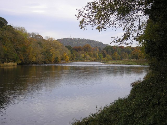
 The River Tweed at Abbotsford, near Melrose
 The River Tweed from Mertoun House, near St Boswells
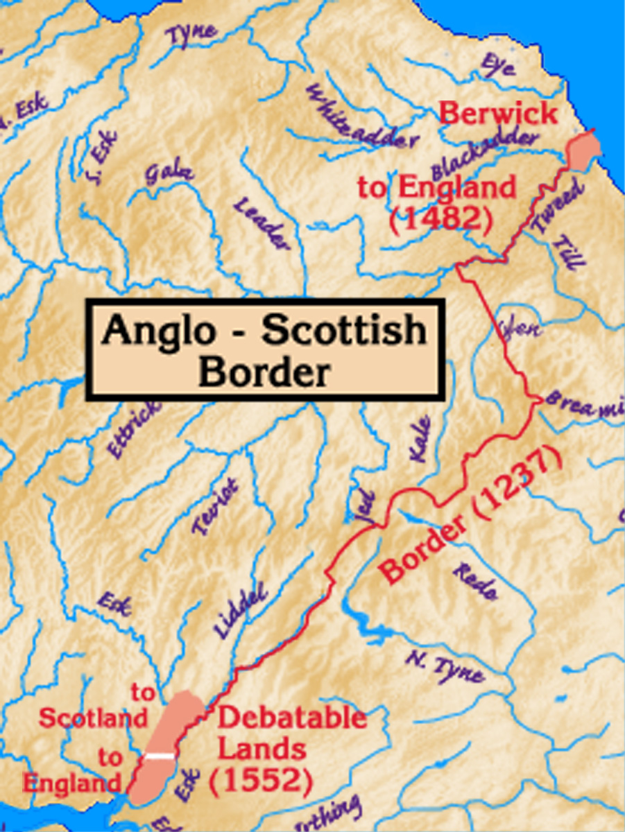
 The Anglo-Scottish border, with the Tweed on the east. Its estuary and the town of Berwick-upon-Tweed were a late annexation by England.
 The Union Chain Bridge spanning the Tweed between Horncliffe, England and Fishwick, Scotland


Notes
- Clayton, Phil (2012). Headwaters: Walking to British River Sources (First ed.). London: Frances Lincoln Limited. p. 193. ISBN 9780711233638.
- "Article on Tweed Cloth". Archived from the original on 16 December 2014. Retrieved 16 December 2014.
- "Wild fishing tax 'raid' concern". 10 August 2015 – via www.bbc.com.
- "University of Wales Dictionary". University of Wales Dictionary. University of Wales. Archived from the original on 31 May 2019. Retrieved 4 June 2019.
- James, Alan. "The Brittonic Language in the Old North - A Guide to the Place-Name Evidence" (PDF). Scottish Place Name Society.
- The Tweed: Take a trip on a river flowing with history Archived 2019-07-31 at the Wayback Machine, The Independent, 21 April 2007
- "National Scenic Areas". Scottish Natural Heritage. Archived from the original on 18 January 2018. Retrieved 17 January 2018.
- "History of the RTC". www.rivertweed.org.uk/. Retrieved 22 February 2022.
External links
- British Waterways: River Tweed
- The River Tweed Commission website
- The Tweed Foundation
- Tweed Forum website
- River Tweed: Special Area of Conservation (SAC)
- SEPA (Scottish Environment Protection Agency): River Level Data
- River Tweed map
- Gazetteer for Scotland: River Tweed
- Paper describing palaeo-icestream and landforms in the Tweed Valley
- Map and aerial photo sources for Tweed's Well and Tweedmouth
- Open Canoe Hire Specialists
| Authority control: National libraries |
|---|
На других языках
[de] Tweed (Nordsee)
Der Fluss Tweed (engl. River Tweed) ist 156 Kilometer lang und fließt hauptsächlich durch die Region Scottish Borders in Schottland. Er entspringt bei Tweedsmuir und entwässert die gesamte Grenzregion. Im späteren Verlauf bildet er über eine Strecke von 27 Kilometern die Grenzlinie zwischen Schottland und England. Zudem ist er bekannt als Fischereigewässer für Lachs.- [en] River Tweed
[es] Tweed (río)
El río Tweed (o Uisge Thuaidh en gaélico) es un río existente en el sur de Escocia, en el Reino Unido, que tiene una longitud total de 156 km, siendo el undécimo río por su longitud de todo el Reino Unido y el cuarto de Escocia. El río Tweed atraviesa completamente la región de los Scottish Borders.[it] Tweed (fiume)
Il fiume Tweed (nome completo in inglese River Tweed o Tweed Water; in gaelico scozzese Abhainn Thuaidh; in passato, in italiano, la Tueda[1]) è un fiume lungo 156 km (97 miglia) che scorre principalmente attraverso l'area amministrativa degli Scottish Borders, una regione della Scozia.[ru] Туид (река)
Туид (также Твид) (англ. River Tweed, гэльск. Uisge Thuaidh) — река, протекающая в пограничном районе между Англией и Шотландией и формирующая административную границу между ними на протяжении 27 км до устья. Длина реки составляет 156 км[1]. Туид является 11-й по длине рекой Великобритании. Исток реки находится на холмах рядом с деревней Туидсмюир и недалеко от истоков рек Клайд, текущей на северо-запад, и Аннан, текущей на юг. Существует поговорка, отражающая факт истока этих трёх значительных рек из одной местности: «англ. Annan, Tweed and Clyde rise oot the ae hillside» («Аннан, Туид и Клайд начинаются с этих холмов»). Река впадает в Северное море в городе Берик-апон-Туид.Другой контент может иметь иную лицензию. Перед использованием материалов сайта WikiSort.org внимательно изучите правила лицензирования конкретных элементов наполнения сайта.
WikiSort.org - проект по пересортировке и дополнению контента Википедии