geo.wikisort.org - Island
Flotta (/ˈflɒtə/) is a small island in Orkney, Scotland, lying in Scapa Flow. The island is known for its large oil terminal and is linked by Orkney Ferries to Houton on the Orkney Mainland, Lyness on Hoy and Longhope on South Walls. The island has a population of 80.
| Old Norse name | Flottey[1] or Flott-øy[2] |
|---|---|
| Meaning of name | "flat island" (Norse) |
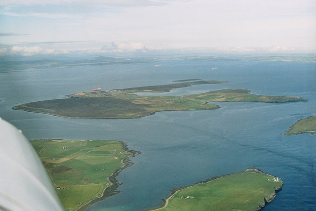 An aerial view of Flotta from the south-west. The oil terminal is visible to the centre-left, with the airport further to the left. South Walls is at the bottom and bottom left, and Switha at the extreme right. | |
| Location | |
 Flotta Flotta shown within Orkney | |
| OS grid reference | ND352938 |
| Coordinates | 58.83°N 3.1°W |
| Physical geography | |
| Island group | Orkney |
| Area | 876 hectares (3.4 sq mi) |
| Area rank | 57 [3] |
| Highest elevation | West Hill 58 metres (190 ft) |
| Administration | |
| Sovereign state | United Kingdom |
| Country | Scotland |
| Council area | Orkney Islands |
| Demographics | |
| Population | 80[4] |
| Population rank | 48 [3] |
| Population density | 9.1 people/km2[2][4] |
| Largest settlement | Whome |
| References | [2][5] |
History
At the turn of the 20th century, the island was a quiet rural community like many other small islands of Orkney, but its sheltered location led to three major upheavals in the island in the century.
Until 1914, Flotta was a quiet farming community. In 1910, a population of 431 included two blacksmiths, four carpenters and three dressmakers.
World Wars

This section needs expansion with: details of Second World War structures such as the
|
Everything changed with the arrival of the Royal Navy in Scapa Flow at the start of the First World War. There is a photograph held by the Imperial War Museum in London that shows a boxing match taking place on Flotta in front of a wartime audience of 10,000 people.
During the First World War, the island was home to a naval base. The dreadnought HMS Vanguard sank nearby in 1917, reputedly the worst maritime disaster in UK waters. In the Second World War, the island was again used as a military base.
1918 saw the mass exodus of Navy personnel, and 1939 saw their return. After the Second World War the island had good piers and facilities, but a slowly declining population. It took until 1970 for fresh water to be piped to the island from Hoy.
North Sea oil

In 1974, Occidental Petroleum started construction of the island's oil terminal. This became the second largest major oil terminal serving the UK North Sea, the largest being Sullom Voe in Shetland.
It took only two years from the start of construction until the first of the crude oil was pumped into the terminal, during which thousands of workers were posted at the "camp" in Flotta to complete the facility as Britain's thirst for oil was growing by the day. The Flotta oil terminal was opened by the energy minister, Tony Benn MP, on 11 January 1977.[6]
The oil terminal provides the landing for the Piper and Claymore fields pipeline system. In addition, it provides a safe facility for the receipt and transshipment of oil produced from the UK Atlantic margins.
Geography and environment
Flotta lies at the southern end of Scapa Flow, with Calf of Flotta being at the north-east corner of the island. The island of Fara is 300 m (980 ft) across Weddel Sound, to the north-west. Meanwhile, Switha, South Walls and Hoy are each approximately 1 km (0.62 mi) from Flotta, to the south, south-west and west, respectively. Nevi Skerry is situated 1 km (0.62 mi) east of Flotta in the Sound of Hoxa. South Ronaldsay is approximately 2.5 km (1.6 mi) east of Flotta, also across the sound of Hoxa. The highest point on Flotta is West Hill at 58 m (190 ft), adjacent to the wind turbine. The main population centre is at Whome, which is situated in the centre of the southern half of the island. To the north, Whome is separated from the Golta Peninsula by Pan Hope, a tidal bay.
Flora and fauna
Flotta has a seal colony at Stanger Head, at the south-east corner of the island.[7] The Royal Navy planted 1000 spruce trees during the Second World War, which are situated between Sutherland Pier and the oil terminal, in the vicinity of the Naval Cinema. About 10% of the spruce trees survive.[7] The oil company has also planted 40,000 trees and shrubs.[7] Much of the western side of the island is heath, as is the Golta Peninsula to the north-east of the island.
Community

This section needs expansion with: details of
|
The island has a usually resident population of 80 people in 48 households.[4] The main centre of population is in the settlement of Whome. The community primary school is mothballed due to there being no children of that age left on the island.[8]
Healthcare services are provided by the Stromness Surgery, with a nurse practitioner based on Flotta.[9] Flotta Fire Station, which is situated next to the school, formally closed on 25 October 2012.[10] The service provided by the fire station was transferred to the Scottish Fire and Rescue Service on 1 April 2013.[11]
The 2.3MW wind turbine, which was installed in 2010, will provide the community with a cash contribution of £100,000 over the lifetime of the turbine.[12]
People from Flotta
- Prof Sutherland Simpson FRSE (1863-1926) physiologist
Economy


The main industry on the island is energy production and distribution. Repsol Sinopec Energy UK Limited's Flotta oil terminal, processes oil from the North Sea for onward transfer. The oil terminal has been operational for 36 years.[13] Opus Plus Ltd., an environmental research company, is also based within the oil terminal complex. Supplied by German manufacturer Enercon, the 2.3MW Flotta wind turbine was brought online in June 2010[14] at a cost of £3 million.[12] The turbine, which is connected to the National Grid,[14] has a hub height of 64 m (210 ft) and a rotor diameter of 71 m (233 ft).[12]
The Orkney Island Council provides employment to several people on Flotta. Farming remains an important source of revenue for the island economy, along with handicraft. A small number of residents are also employed on the Orkney Mainland.[13]
The island is served by one shop, which operates as a general store, a post office and a petrol station.[15] The nearest supermarkets are situated in Kirkwall, on the Orkney Mainland, which has branches of Tesco and Lidl.
The island has a mains water supply, and boreholes are also used. Flotta didn't have a mains electricity supply until 1977, although most households had had their own electricity generators for many years beforehand.[16] Mains electricity is supplied by Scottish Hydro Electric.[17] The island is connected to the BT telephone network.[17] Mobile phone connections can be an issue.[13][17] Broadband internet connection is possible on the island.[13] There is no mains gas supply on Flotta,[17] although coal and heating oil are delivered regularly, and Calor Gas is stored at the shop.[13]
In 2005, Flotta was considered to have the potential of expanding the island economy with heritage tourism, and with a particular regard for the Second World War-era structures which are spread across the island.[18] The possible development of a marina was also considered, at that time.[18]
Transport
Marine

The island is served by Orkney Ferries with ferry links to Houton on the Orkney Mainland, Lyness on Hoy, and Longhope on South Walls. The ferries berth at Gibraltar Pier,[19] also known as Heyspan Pier,[20] which is to the north-west of the island in Weddel Sound. Orkney Ferries' South Isles service is usually provided by MV Hoy Head, whilst MV Thorsvoe serves as a relief vessel.[21] Flotta is situated a few miles from St Margaret's Hope on South Ronaldsay, which has a direct ferry service to mainland Scotland. However, there is no direct public ferry service between Flotta and South Ronaldsay, across the Sound of Hoxa. For a transport connection to the Scottish mainland, one must instead travel by ferry to Houton, and then by road to either Stromness or to St. Margaret's Hope, via a much more circuitous route.
A couple of hundred metres to the south-west of Gibraltar Pier is Sutherland Pier, also in Weddel Sound. Sutherland Pier is used by local vessels of similar size to the ferries. A third public pier, Pan Pier, is situated at the southern side of Pan Hope, the island's central bay. Pan Pier is used by smaller private boats. The oil terminal has its own jetty on the northern side of the island, which has the capability to accommodate oil tankers.
Airport

Flotta Airport is situated on the western side of the island, with the IATA code of FLH.[22] The asphalt runway orientation is at 16/34, with an elevation of 70 feet (21 m), and is 2,490 feet (760 m) in length.[23] The airport also has a helipad, adjacent to the eastern side of the northern end of the runway.
The first landing on Flotta was made by a Loganair Islander aircraft, G-AWNR, on 28 May 1976.[6] The first scheduled air service to Flotta was flown via Hoy on 1 March 1977 and the service was flown by another Loganair Islander aircraft, G-AXVR.[6] Crew change operations for the Occidental Petroleum oil terminal were also performed by a British Airways HS748.[6] Loganair's scheduled services to Flotta were discontinued in 1981, as a direct result of free ferry services being provided by the oil company.[6]
On 20 April 1983, a charter flight from Aberdeen Airport of an Air Ecosse de Havilland DHC-6, aircraft registration G-STUD, crashed at Flotta Airport. The aircraft was caught in a strong crosswind as it landed, which caused the crash. There were no serious injuries, and no fatalities, amongst the two crew and ten passengers.[24][25][26]
In 2001 the airstrip changed hands to Elf Exploration UK plc and today the airfield is mainly used by emergency services.[27]
Road
The main roads on Flotta are the B9045 and the B9046, which connect the ferry terminal with the settlement of Whome. Flotta has no causeways similar to the Churchill Barriers, which could allow vehicles to be driven to the nearby islands. All road vehicles are reliant on using the ferry to the Orkney Mainland, and to Hoy.
See also
References
Notes
- Anderson, Joseph (ed.) (1873) The Orkneyinga Saga. Translated by Jón A. Hjaltalin & Gilbert Goudie. Edinburgh. Edmonston and Douglas. The Internet Archive. Retrieved 26 August 2013.
- Haswell-Smith, Hamish (2004). The Scottish Islands. Edinburgh: Canongate. ISBN 978-1-84195-454-7.
- Area and population ranks: there are c. 300 islands over 20 ha in extent and 93 permanently inhabited islands were listed in the 2011 census.
- National Records of Scotland (15 August 2013). "Appendix 2: Population and households on Scotland's Inhabited Islands" (PDF). Statistical Bulletin: 2011 Census: First Results on Population and Household Estimates for Scotland Release 1C (Part Two) (PDF) (Report). SG/2013/126. Retrieved 14 August 2020.
- Ordnance Survey. OS Maps Online (Map). 1:25,000. Leisure.
- Warner, Guy (2005). Orkney by Air - A photographic journey through time. Renfrewshire: Kea Publishing. pp. 48–52. ISBN 978-0-9518958-7-0.
- "The Islands of Orkney brochure" (PDF). orkneyferries.co.uk. Archived from the original (PDF) on 9 September 2014. Retrieved 8 September 2014.
- "Flotta Community School". Retrieved 8 July 2018.
- "General Practices (GPs) - NHS Orkney". NHS Orkney. Archived from the original on 12 August 2014. Retrieved 8 September 2014.
- "Minutes of the meeting of Flotta Community Council 22 OCTOBER 2012" (PDF). orkney.gov.uk. Archived from the original (PDF) on 8 September 2014. Retrieved 8 September 2014.
- "Fire Station Details - Flotta fire station". firestations.org.uk. Retrieved 8 September 2014.
- "Home: Flotta Wind Power". flottawindpower.co.uk. Retrieved 8 September 2014.
- "Flotta - The flat island". lurdy.wordpress.com. 27 May 2011. Retrieved 8 September 2014.
- "History: Flotta Wind Power". flottawindpower.co.uk. Retrieved 8 September 2014.
- "Flotta - The flat island". flickr. 29 May 2008. Retrieved 11 September 2014.
- "George Barnett's Travels Part 2, Lurdy, Flotta". lurdy.wordpress.com. 15 April 2013. Retrieved 11 September 2014.
- "Welcome to Orkney". orkneycommunities.co.uk. Archived from the original on 28 November 2009. Retrieved 11 September 2014.
- "Community Engagement, Report from Flotta - October 2005". Orkneycommunities.co.uk. Archived from the original on 16 December 2007. Retrieved 8 September 2014.
- "Flotta - Gibraltar Pier" (PDF). orkneyharbours.com. Archived from the original (PDF) on 8 September 2014. Retrieved 8 September 2014.
- "Heyspan Pier". Geograph. Retrieved 8 September 2014.
- "The Fleet". Orkney Ferries. Archived from the original on 13 September 2010. Retrieved 7 September 2014.
- "FLH - Flotta Isle, Orkney Isles, Scotland, GB - Airport". Great Circle Mapper. Retrieved 7 September 2014.
- "Flotta". ivao.aero. Retrieved 7 September 2014.
- "Orkney Image Library - Flotta Plane Crash". orkneycommunities.co.uk. Retrieved 8 September 2014.
- "Aircraft Accident Report 8/83" (PDF). aaib.gov.uk. Retrieved 8 September 2014.
- "ASN Aircraft accident de Havilland Canada DHC-6 Twin Otter 310 G-STUD Flotta Airport (FLH)". Aviation Safety Network. Retrieved 8 September 2014.
- "Forgotten airfields". www.forgottenairfields.com. Retrieved 30 March 2020.
External links
|  | ||||||||||||||||
|
| |||||||||||||||||
| |||||||||||||||||
| |||||||||||||||||
| |||||||||||||||||
| |||||||||||||||||
| |||||||||||||||||
| |||||||||||||||||
| Authority control |
|
|---|
На других языках
[de] Flotta
Die Insel Flotta (eigentlich Flottay; von Norn Fleuks (Flunder) „die flache Insel“) gehört zur Gruppe der Orkneys und liegt etwa 30 km nord-nordöstlich vor Schottland. 2011 lebten 80 Personen auf Flotta.[1]- [en] Flotta
[es] Flotta
Flotta es una isla perteneciente al grupo sur del archipiélago de las Órcadas, en Escocia. Es conocida por su gran terminal petrolero. La isla se une por ferry a través de Scapa Flow con Mainland y Lyness y Longhope en Hoy. Durante las Guerras Mundiales, la isla fue una importante base para la Royal Navy. La isla tiene una población de 80 habitantes.[fr] Flotta
Flotta est une petite île du Royaume-Uni située en Écosse, dans les Orcades. Elle est reliée à Houton, sur Mainland, par ferry.[it] Flotta (isola)
Flotta è una piccola isola dell'arcipelago delle Orcadi in Scozia. L'isola è nota per il suo grande porto petrolifero ed è collegata a Houton nella Mainland tramite i traghetti delle Orcadi (Orkney Ferries).Другой контент может иметь иную лицензию. Перед использованием материалов сайта WikiSort.org внимательно изучите правила лицензирования конкретных элементов наполнения сайта.
WikiSort.org - проект по пересортировке и дополнению контента Википедии