geo.wikisort.org - IslandHolm of Grimbister is an inhabited tidal islet in the Orkney archipelago of Scotland. Located in the Bay of Firth near Finstown it is connected to Mainland Orkney by a causeway.
Holm of Grimbister| Meaning of name | Small and rounded islet of Grim's farm |
|---|
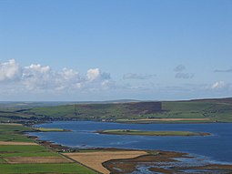
Holm of Grimbister from the east, with Finstown beyond |
|
Holm of Grimbister shown within Orkney |
| OS grid reference | HY378134 |
|---|
| Coordinates | 59.0036°N 3.0836°W / 59.0036; -3.0836 |
|---|
|
| Island group | Orkney |
|---|
| Area | 16 hectares (40 acres)[1] |
|---|
| Highest elevation | 8 m (26 ft)[2] |
|---|
|
| Sovereign state | United Kingdom |
|---|
| Country | Scotland |
|---|
| Council area | Orkney Islands Council |
|---|
|
| Population | 3[3] |
|---|
| Population rank | 80= [4] |
|---|
| Largest settlement | Holm of Grimbister farm[2] |
|---|
|
Geography
Bay of Firth is an inlet of the Wide Firth that lies to the North. Within the bay and to the north east of the Holm is the companion islet of Damsay. The causeway from Holm of Grimbister connects to the mainland at Holm Point, just north of the mainland settlement of Grimbister.[2] Haswell-Smith (2004) notes that the islet is farmed.[5]
Habitation
Although it is clear that in 2007 the island was inhabited, as it was the residence of a candidate for the Scottish Parliamentary Elections in 2007,[6] it was not listed as such by the Census in 2001.[7] Press reports in March 2010 confirmed that at that time the population of the island was at least two.[8] The 2011 census recorded the population as three.[3] In 2016 the island was reported as being on sale for £300 000.
References
Orkney |
|---|
|
| Inhabited islands | |
|---|
| Other islands | |
|---|
| Towns and villages |
- Kirkwall
- Balfour
- Dounby
- Finstown
- Houton
- Longhope
- Lyness
- Pierowall
- St Margaret's Hope
- Stromness
- Whitehall
|
|---|
| Mainland parishes |
- Birsay
- Deerness
- Evie
- Firth
- Harray
- Holm
- Orphir
- Rendall
- St Andrews
- St Ola
- Sandwick
- Stenness
- Stromness
|
|---|
| Topics |
- Geology
- Prehistory
- History
- Scapa Flow
- Witchcraft
|
|---|
| Politics |
- Earls of Orkney
- Orkney Islands Council
- Flag of Orkney
- Orkney (Scottish Parliament constituency)
- Orkney and Shetland (UK Parliament constituency)
- Orcadian Women's Suffrage Society
|
|---|
| Sport |
- Kirkwall Ba game
- Orkney Amateur Football Association
- Orkney F.C.
- Orkney representative football team
|
|---|
|
|---|
Geography |
|---|
| Northern Isles | |
|---|
| Hebrides | |
|---|
| Other | |
|---|
|
| |
Prehistory |
|---|
| Prehistoric Orkney |
- Heart of Neolithic Orkney World Heritage Site:
- Maeshowe
- Ness of Brodgar
- Ring of Brodgar
- Skara Brae
- Standing Stones of Stenness
|
|---|
| Prehistoric Shetland |
- Crucible of Iron Age Shetland:
- Broch of Mousa
- Jarlshof
- Old Scatness
|
|---|
| Prehistoric Western Isles | |
|---|
|
|
History |
|---|
| Dál Riata | |
|---|
| Kingdom of the Isles |
- Scandinavian Scotland
- Rulers of the Kingdom of the Isles
- Bishop of the Isles
|
|---|
| Lordship of the Isles |
- Treaty of Perth
- Treaty of Ardtornish-Westminster
- Finlaggan
|
|---|
| Earldom of Orkney |
- Buckquoy spindle-whorl
- Udal law
|
|---|
| 18th and 19th Century |
- Clearances
- Jacobite risings
- Flora MacDonald
|
|---|
| Literature |
- Orkneyinga Saga
- Description of the Western Isles of Scotland (Monro)
- A Description of the Western Isles of Scotland (Martin)
- A Journey to the Western Islands of Scotland (Johnson)
- The Journal of a Tour to the Hebrides (Boswell)
|
|---|
|
|
|
Economy |
|---|
| Towns |
- Kirkwall
- Lerwick
- Rothesay
- Stornoway
- Stromness
|
|---|
| Agencies | |
|---|
| Oil industry | |
|---|
|
|
Culture |
|---|
| Shetland | |
|---|
| Orkney | |
|---|
| Outer Hebrides | |
|---|
| Inner Hebrides | |
|---|
|
|
Politics |
|---|
| Local authorities |
- Shetland Islands Council
- Orkney Islands Council
- Comhairle nan Eilean Siar
- Highland Council
- Argyll and Bute
- North Ayrshire
|
|---|
|
|
Wildlife |
|---|
| Fauna |
- Fair Isle wren
- Orkney vole
- Shetland wren
- St Kilda field mouse
- St Kilda wren
|
|---|
| Flora |
- Arran whitebeams
- Scottish Primrose
- Shetland Mouse-ear
|
|---|
| Domesticated animals |
- Cairn Terrier
- Eriskay Pony
- Hebridean Blackface
- Luing cattle
- North Ronaldsay sheep
- Scottie
- Sheltie
- Shetland cattle
- Shetland Goose
- Shetland pony
- Shetland sheep
- Soay sheep
- Westie
|
|---|
|
|
Geology |
|---|
| Shetland | |
|---|
| Geology of Orkney |
- Eday Group
- Orcadian Basin
- Yesnaby Sandstone Group
|
|---|
| Hebrides |
- Colonsay Group
- Great Estuarine Group
- Hebridean Terrane
- Lewisian complex
- Lorne plateau lavas
- Moine Supergroup
- Moine Thrust Belt
- Mull
- Rhinns complex
- Skye
- Staffa
- Torridonian
|
|---|
| Islands of the Clyde | |
|---|
|
|
На других языках
[de] Holm of Grimbister
Holm of Grimbister ist eine bis zu 8,0 m hohe bewohnte Gezeiteninsel in der Firth Bay, die über einen Damm mit Finstown auf der Orkneyinsel Mainland in Schottland verbunden ist. Die Bay of Firth ist eine Bucht des Wide Firth, der im Norden liegt. In der Bucht befindet sich nordöstlich von Holm die unbewohnte Begleitinsel Damsay. Der Damm des Holm of Grimbister verbindet die Insel mit dem Holm Point, nördlich von Finstown auf dem Festland.
- [en] Holm of Grimbister
Текст в блоке "Читать" взят с сайта "Википедия" и доступен по лицензии Creative Commons Attribution-ShareAlike; в отдельных случаях могут действовать дополнительные условия.
Другой контент может иметь иную лицензию. Перед использованием материалов сайта WikiSort.org внимательно изучите правила лицензирования конкретных элементов наполнения сайта.
2019-2025
WikiSort.org - проект по пересортировке и дополнению контента Википедии


