geo.wikisort.org - IslandSeaforth Island (Scottish Gaelic: Eilean Shìphoirt/Shìophoirt or Mulag) is an uninhabited island in the Outer Hebrides of Scotland. Unlike many other islands of the Outer Hebrides which are mainly surrounded by open sea, Seaforth Island lies in a narrow fjord-like sea loch named Loch Seaforth, 8 kilometres (5.0 mi) from the open waters of The Minch.
- There is also a Seaforth Island in the Whitsunday Islands of Queensland, Australia
Seaforth Island| Scottish Gaelic name | Eilean Shìophoirt or Mulag |
|---|
| Old Norse name | Múli |
|---|
| Meaning of name | Norse for 'craggy ridge between fjords'; Gaelic for "island of Seaforth" |
|---|
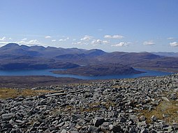
Loch Seaforth and Eilean Shìophoirt from the north with Clisham beyond |
|
Seaforth Island shown within the Outer Hebrides |
| OS grid reference | NB207111 |
|---|
| Coordinates | 58.00°N 06.7292°W / 58.00; -06.7292 |
|---|
|
| Island group | Outer Hebrides |
|---|
| Area | 273 hectares (1.05 sq mi) |
|---|
| Area rank | 92 [1] |
|---|
| Highest elevation | 217 metres (712 ft) |
|---|
|
| Sovereign state | United Kingdom |
|---|
| Country | Scotland |
|---|
| Council area | Outer Hebrides |
|---|
|
| Population | 0 |
|---|
|
| References | [2][3][4] |
|---|
| Seaforth Island |
|---|
|
| Elevation | 217 m (712 ft) |
|---|
| Prominence | 217 m (712 ft) |
|---|
| Listing | Marilyn |
|---|
|
| Location | Loch Seaforth between Harris and Lewis, Scotland |
|---|
| OS grid | NB207111 |
|---|
| Topo map | OS Landrangers 13, 14 |
|---|
The island has poor soil which only supports rough grazing.
History
There are no census records indicating inhabitation in the recent past, although the loch area was the subject of border disputes in the 19th century. In 1851 these were resolved by the unusual decision to allocate the whole of Seaforth Island to both counties, Ross-shire and Inverness-shire, which at the time controlled Lewis and Harris respectively.[4] This situation continued until the 1975 county reorganisation.
Gallery
|
|---|
|
| Inhabited islands | | |
|---|
| Other islands | |
|---|
| Settlements | |
|---|
| Districts | |
|---|
| Geographical features | |
|---|
| Historical sites |
- Callanish Stones
- Clach an Trushal and Steinacleit
- Dun Carloway
- Dùn Èistean
- Lews Castle
- St Clement's Church
- Teampall Mholuaidh
|
|---|
|
|---|
Geography |
|---|
| Northern Isles | |
|---|
| Hebrides | |
|---|
| Other | |
|---|
|
| |
Prehistory |
|---|
| Prehistoric Orkney |
- Heart of Neolithic Orkney World Heritage Site:
- Maeshowe
- Ness of Brodgar
- Ring of Brodgar
- Skara Brae
- Standing Stones of Stenness
|
|---|
| Prehistoric Shetland |
- Crucible of Iron Age Shetland:
- Broch of Mousa
- Jarlshof
- Old Scatness
|
|---|
| Prehistoric Western Isles | |
|---|
|
|
History |
|---|
| Dál Riata | |
|---|
| Kingdom of the Isles |
- Scandinavian Scotland
- Rulers of the Kingdom of the Isles
- Bishop of the Isles
|
|---|
| Lordship of the Isles |
- Treaty of Perth
- Treaty of Ardtornish-Westminster
- Finlaggan
|
|---|
| Earldom of Orkney |
- Buckquoy spindle-whorl
- Udal law
|
|---|
| 18th and 19th Century |
- Clearances
- Jacobite risings
- Flora MacDonald
|
|---|
| Literature |
- Orkneyinga Saga
- Description of the Western Isles of Scotland (Monro)
- A Description of the Western Isles of Scotland (Martin)
- A Journey to the Western Islands of Scotland (Johnson)
- The Journal of a Tour to the Hebrides (Boswell)
|
|---|
|
|
|
Economy |
|---|
| Towns | |
|---|
| Agencies | |
|---|
| Oil industry | |
|---|
|
|
Culture |
|---|
| Shetland | |
|---|
| Orkney | |
|---|
| Outer Hebrides | |
|---|
| Inner Hebrides | |
|---|
|
|
Politics |
|---|
| Local authorities |
- Shetland Islands Council
- Orkney Islands Council
- Comhairle nan Eilean Siar
- Highland Council
- Argyll and Bute
- North Ayrshire
|
|---|
|
|
Wildlife |
|---|
| Fauna |
- Fair Isle wren
- Orkney vole
- Shetland wren
- St Kilda field mouse
- St Kilda wren
|
|---|
| Flora |
- Arran whitebeams
- Scottish Primrose
- Shetland Mouse-ear
|
|---|
| Domesticated animals |
- Cairn Terrier
- Eriskay Pony
- Hebridean Blackface
- Luing cattle
- North Ronaldsay sheep
- Scottie
- Sheltie
- Shetland cattle
- Shetland Goose
- Shetland pony
- Shetland sheep
- Soay sheep
- Westie
|
|---|
|
|
Geology |
|---|
| Shetland | |
|---|
| Geology of Orkney |
- Eday Group
- Orcadian Basin
- Yesnaby Sandstone Group
|
|---|
| Hebrides |
- Colonsay Group
- Great Estuarine Group
- Hebridean Terrane
- Lewisian complex
- Lorne plateau lavas
- Moine Supergroup
- Moine Thrust Belt
- Mull
- Rhinns complex
- Skye
- Staffa
- Torridonian
|
|---|
| Islands of the Clyde | |
|---|
|
|
На других языках
[de] Seaforth Island
Die unbesiedelte Seaforth Island (gälisch: Eilean Shìophort) ist eine schottische Insel der Äußeren Hebriden.[1]
- [en] Seaforth Island
[fr] Seaforth (Écosse)
Seaforth est une île du Royaume-Uni située en Écosse dans les Hébrides extérieures.
Текст в блоке "Читать" взят с сайта "Википедия" и доступен по лицензии Creative Commons Attribution-ShareAlike; в отдельных случаях могут действовать дополнительные условия.
Другой контент может иметь иную лицензию. Перед использованием материалов сайта WikiSort.org внимательно изучите правила лицензирования конкретных элементов наполнения сайта.
2019-2026
WikiSort.org - проект по пересортировке и дополнению контента Википедии


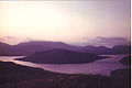 The Island from Lewis and Harris
 Shore of Seaforth Island


