geo.wikisort.org - Island
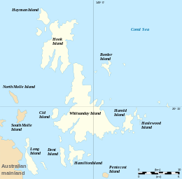
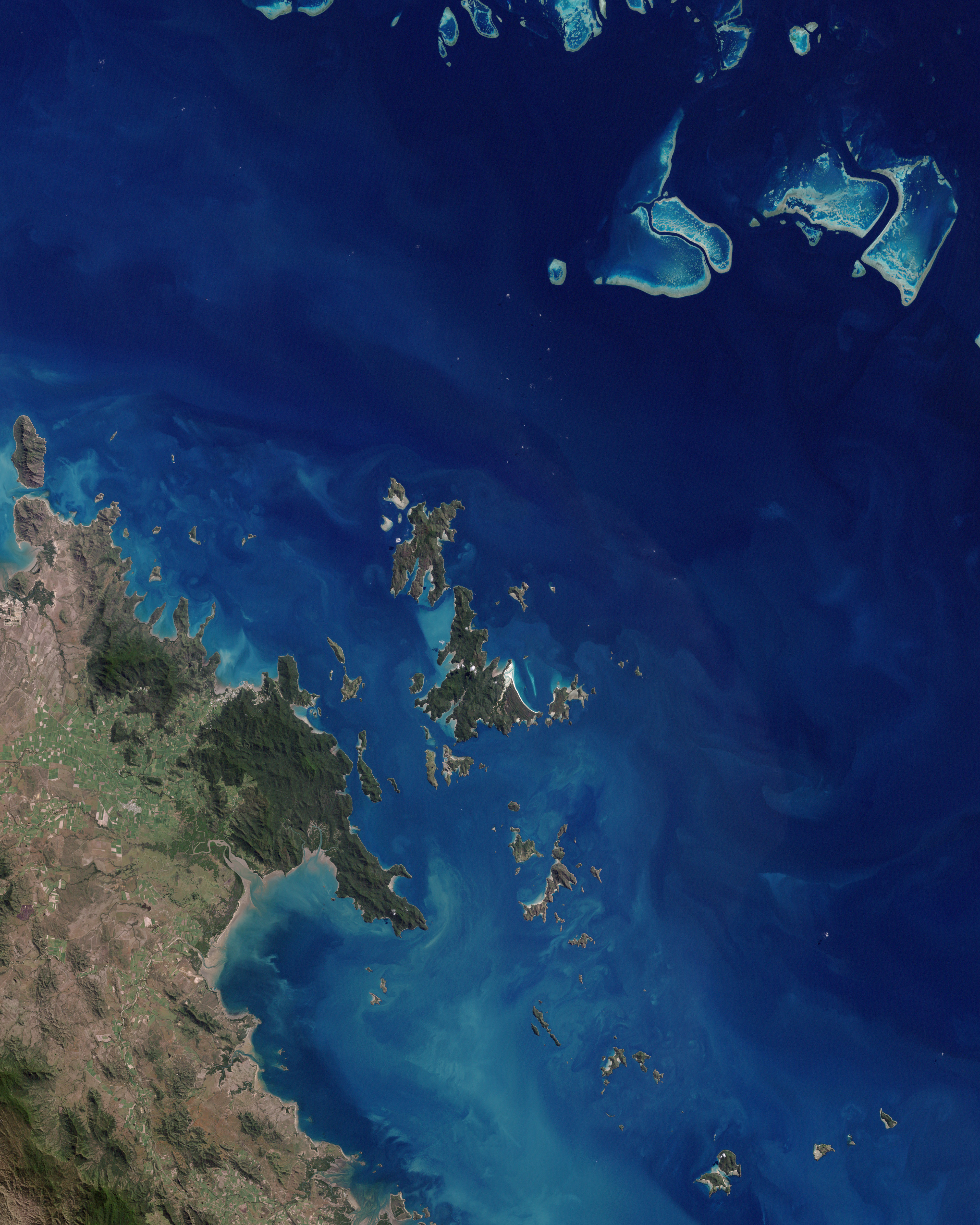
The Whitsunday Islands are 74 continental islands of various sizes off the central coast of Queensland, Australia, 900 kilometres (560 miles) north of Brisbane.[1] The northernmost of the islands are off the coast by the town of Bowen, while the southernmost islands are off the coast by Proserpine. The island group is centred on Whitsunday Island, while the commercial centre is Hamilton Island. The traditional owners of the area are the Ngaro people and the Gia people, whose Juru people has the only legally recognised native title in the Whitsunday Region.[2]
 | |
 | |
| Geography | |
|---|---|
| Location | Queensland, Australia |
| Coordinates | 20°18′S 148°56′E |
| Total islands | 74 |
| Major islands | Hamilton Island |
| Area | 282.82 km2 (109.20 sq mi) |
| Administration | |
Australia | |
| State | Queensland |
| Largest settlement | Hamilton Island (pop. 1350) |
| Demographics | |
| Population | 1,570 (2014) |
| Pop. density | 5.551/km2 (14.377/sq mi) |
The islands are within the locality of Whitsundays and the local government Whitsunday Region.[3] In 2009, as part of the Q150 celebrations, the Whitsunday Islands became one of the Q150 Icons of Queensland for their role as a natural attraction.[4]
Naming
On Sunday 3 June 1770, (the day Whitsun—Pentecost was celebrated on the Christian calendar) Captain James Cook sailed his ship H.M.B. Endeavour, through a broad expanse of islands which provided an unimpeded passage to the north. Cook named the passage "Whitsundays' Passage".[5] Cook's recorded times and dates are often questioned. Time quoted is simply local time (calculated at Noon), the Date recorded is a little more confusing. Cook recorded Marine Time (PM comes before AM or GMT+12 hours). Considering the International Date Line, and knowing today's date on the East Coast of Australia is calculated at GMT+10 - Cook's recorded date is fortuitously correct.
There is some contention as to exactly which islands are within the informally named Whitsunday Islands, in particular those at the southern extremity and the inclusions to the west. What is certain is that they lie within the chain named Cumberland Isles by Captain Cook (now officially the Cumberland Islands) and a reasonably defined section of that chain and surrounding waters have become known worldwide as The Whitsundays, based on a contraction of the Whitsunday Islands designation.
Tourism
The Whitsunday islands are a popular tourist destination for travellers to Queensland and the Great Barrier Reef with the area being one of the most popular yachting destinations in the Southern Hemisphere. The islands received about 700,000 visitors between March 2008 and March 2009.[6]
The Whitsunday Ngaro Sea Trail[7] is a mix of seaways and short walks, crossing South Molle, Hook and Whitsunday islands.[8] The tracks across the islands are linked by seaways suited to kayaking, sailing or powerboating. Camping is available at eight camping areas on the three islands. Several islands have large resorts, offering a wide variety of accommodation and activities. Chartering a yacht or bareboating is a popular way to explore the seaways, beaches and coves.
The Ngaro Whitsundays Underwater Art Trail [9] is a series on sculptures of Turtle, Manta ray, Maori wrasse, Coral polyp and a traditional piece named Bywa. They are located in shallow water depths assessable for snorkelling.
Components
There are a total of 74 islands and islets among all the groups in the Whitsundays.
Whitsunday group
The most notable islands in the main Whitsunday group are named Dent, Hamilton, Hayman, Hook and Whitsunday which features the white sands of Whitehaven Beach.
Lindeman group
The best known island in the Lindeman group is its namesake Lindeman Island (20.4456°S 149.0425°E).[10] However the largest island in the group is Shaw Island (20.4867°S 149.0756°E).[11]
Molle group
The most notable islands in the Molle group are Daydream Island (formerly West Molle Island), Long Island and South Molle Island.
Northern group
Some of the islands in the Northern group are Armit, Gloucester and Saddleback.
 Whitehaven Beach on Whitsunday Island
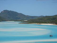 Hill inlet, north of Whitehaven Beach
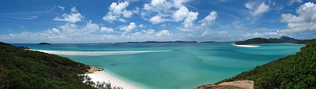 Panoramic view of the Whitsunday Islands
 Planton Island
 Sunset over mainland from summit of South Molle Island's Mount Jeffreys
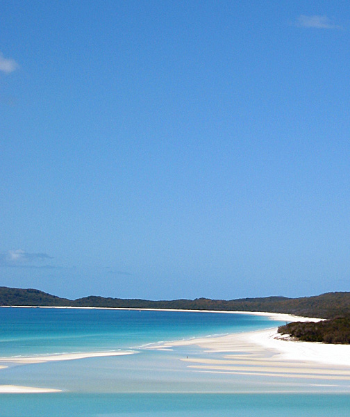


Table of islands
Listed below are islands of The Whitsundays, divided by group locality. Named rocks and islets can be found listed within the entry for the nearest island to that feature.
| Island | Capital | Adjacent islets and features | Area (km²) | Population |
|---|---|---|---|---|
| Lindeman Islands | Lindeman Island | 30.34 | 10 | |
| Baynham Island | 0.074 | 0 | ||
| Comston Island | 0.236 | 0 | ||
| Gaibirra Island | 0.323 | 0 | ||
| Keyser Island | 0.577 | 0 | ||
| Lindeman Island | 6.789 | 10 | ||
| Little Lindeman Island | 0.49 | 0 | ||
| Maher Island | Jesus Point | 0.94 | 0 | |
| Mansell Island | 1.177 | 0 | ||
| Other | Ann Island, Cole Island | 0.222 | 0 | |
| Pentecost Island | 1.25 | 0 | ||
| Seaforth Island | North Beach | 0.265 | 0 | |
| Shaw Island | Neck Bay, Burning Point | 15.62 | 0 | |
| Thomas Island | Thomas Bay, Dead Dog Point | 2.23 | 0 | |
| Triangle Island | 0.115 | 0 | ||
| Volskow Island | 0.032 | 0 | ||
| Molle Islands | South Molle Island | 20.17 | 150 | |
| Daydream Island | Coral Beach, Lovers Beach, Mermaids Beach, Sunset Beach | 0.23 | 30 | |
| Denman Island | 0.095 | 0 | ||
| Goat Island | 0.047 | 0 | ||
| Long Island | Base Point, Fire Point, Happy Bay, Paradise Bay, Pelican Beach, Peppers Palm Bay, Sandy Bay, Spit Point | 10.6 | 80 | |
| Mid Molle Island | 0.13 | 0 | ||
| North Molle Island | 2.643 | 0 | ||
| Other | Gunn Island, Repair Island, Shute Island, Tancerd Island | 0.588 | 0 | |
| Pine Island | 1.063 | 0 | ||
| Planton Island | 0.114 | 0 | ||
| South Molle Island | Bauer Bay | 4.66 | 40 | |
| Northern Group | Gloucester Island | 33.56 | 1 | |
| Armit Island | 1.05 | 0 | ||
| Double Cone Island | 0.4 | 0 | ||
| Eshelby Island | 0.13 | 0 | ||
| Gloucester Island | 26.8 | 0 | ||
| Grassy Island | 1.29 | 0 | ||
| Gumbrell Island | 0.47 | 0 | ||
| Manta Ray Island | 0.32 | 0 | ||
| Middle Island | 0.43 | 0 | ||
| Olden Island | 0.43 | 0 | ||
| Poole Island | 0.19 | 0 | ||
| Rattray Island | 0.23 | 0 | ||
| Saddleback Island | 0.58 | 0 | ||
| Stone Island | 1.24 | 1 | ||
| The Whitsunday Group | Hamilton Island | 198.75 | 1409 | |
| Bird Island | 0.017 | 0 | ||
| Black Island | 0.05 | 0 | ||
| Border Island | Cateran Bay | 3.066 | 0 | |
| Cid Island | Bench Point, Gilling Point | 2.95 | 0 | |
| Cowrie Island | 0.024 | 0 | ||
| Deloraine Island | 0.172 | 0 | ||
| Dent Island | 4.13 | 2 | ||
| Dumbell Island | 0.141 | 0 | ||
| Dungarra Island | 0.094 | 0 | ||
| Esk Island | 0.1 | 0 | ||
| Fitzalan Island | 0.054 | 0 | ||
| Hamilton Island | Crab Bay, South Head, Driftwood Bay, Coral Cove, Escape Beach, Broken Point, Sunrise Bay, Hideaway Bay, Catseye Bay, Pebble Beach, Airport Beach | 7.98 | 1350 | |
| Harold Island | 0.345 | 0 | ||
| Haslewood Island | 7.941 | 0 | ||
| Hayman Island | Dolphin Point, Tower Point, Rescue Beach, Groper Point, Arkhurst Point, Blue Pearl Bay, Royal Hayman Hotel | 3.78 | 50 | |
| Henning Island | 0.496 | 0 | ||
| Hook Island | 54.87 | 5 | ||
| Ireby Island | 0.046 | 0 | ||
| Langford Island | 0.093 | 0 | ||
| Lupton Island | 1.05 | 0 | ||
| Nicolson Island | 0.163 | 0 | ||
| Other | Buddibuddi Island, Yuindalla Island, Petrel Island, Arkhurst Island, Plum Pudding Island | 0.904 | 0 | |
| Perseverance Island | 0.342 | 0 | ||
| Teague Island | 0.558 | 0 | ||
| Titan Island | 0.011 | 2 | ||
| Whitsunday Island | 109 | 0 | ||
| Wirrainbeia Island | 0.04 | 0 | ||
| Workington Island | 0.333 | 0 | ||
| Whitsunday Islands | Totals | 282.82 | 1570 |
See also
- List of islands of Australia
- Regions of Queensland
- Tourism in Australia
- Whitsunday Islands National Park
References
- "Perfectly places: The Whitsundays: The place to live". Whitsunday Regional Council. p. 7. Retrieved 26 January 2020.
- Prior on Behalf of the Juru (Cape Upstart) People v The State of Queensland (No.2) [2011] FCA 819 (26 July 2011), Federal Court (Australia).
- "Queensland Globe". State of Queensland. Retrieved 12 November 2019.
- Bligh, Anna (10 June 2009). "PREMIER UNVEILS QUEENSLAND'S 150 ICONS". Queensland Government. Archived from the original on 24 May 2017. Retrieved 24 May 2017.
- "Trove - Archived webpage".
- Andrew Bain (21 November 2009). "The alternative Whitsunday". Brisbane Times. Fairfax Digital. Retrieved 1 February 2010.
- Science, jurisdiction=Queensland; sector=government; corporateName=Department of Environment and (19 November 2009). "Whitsunday Ngaro Sea Trail". Department of Environment and Science. Retrieved 8 March 2020.
- "Whitsunday Ngaro Sea Trail". Department of National Parks, Recreation, Sport and Racing. 25 March 2011. Retrieved 24 April 2013.
- {{Cite web |url=https://www.tourismwhitsundays.com.au/visitor-information/underwater-marine-sculptures/ title = Ngaro Whitsunday Underwater Art Trail}
- "Lindemann Island – island in the Mackay Region (entry 19445)". Queensland Place Names. Queensland Government. Retrieved 31 August 2021.
- "Shaw Island – island in the Mackay Region (entry 30595)". Queensland Place Names. Queensland Government. Retrieved 31 August 2021.
External links
- Whitsunday Regional Council
- Whitsunday Islands at NASA Earth Observatory
- Whitsunday National Park islands: Nature, culture and history
Australian places named on the First voyage of James Cook in 1770 | ||
|---|---|---|
| Victoria |  | |
| New South Wales |
| |
| Queensland |
| |
*Places where Cook landed | ||
| Authority control |
|
|---|
На других языках
[de] Whitsunday Islands
Die Whitsunday Islands (deutsch Pfingstsonntagsinseln) sind eine Inselgruppe vor der Ostküste des australischen Bundesstaates Queensland.- [en] Whitsunday Islands
[fr] Îles Whitsunday
Les îles Whitsunday sont un archipel d'Australie situé au large des côtes du Queensland. Les îles sont l'une des destinations touristiques les plus prisées du pays. Chaque année, des centaines de milliers de touristes viennent visiter cet endroit et se baigner dans l’eau bleu turquoise de la mer de Corail. La faune et la flore sont aussi les atouts de ces îles avec notamment plus de 150 espèces d’oiseaux. Elles sont accessibles par bateau ou par avion.[it] Isole Whitsunday
Le Isole Whitsunday sono un arcipelago di isole continentali di varie dimensioni situate nel mar dei Coralli al largo della costa centrale del Queensland, in Australia, e fanno parte delle Cumberland Islands. Esse si trovano poco a sud di Bowen e a nord di Mackay, a circa 900 km a nord di Brisbane. L'arcipelago ha come centro la Whitsunday Island, mentre il centro commerciale è l'isola di Hamilton. Gli aborigeni della regione sono il popolo Ngaro e il popolo Gia (del gruppo linguistico Birri Gubba) il cui Juru Clan è l'unico a detenere il titolo di "nativo" riconosciuto da parte della legge australiana.[1][2][ru] Уитсанди
Уитсанди (также Витсандей от англ. Whitsunday) — тихоокеанский архипелаг в Коралловом море к северо-востоку от Квинсленда в Австралии. Выделяются в отдельный регион.Другой контент может иметь иную лицензию. Перед использованием материалов сайта WikiSort.org внимательно изучите правила лицензирования конкретных элементов наполнения сайта.
WikiSort.org - проект по пересортировке и дополнению контента Википедии